


Cloud and rain moving into western areas through the day, central and eastern areas staying dry, fine and sunny. Rain overnight for all clearing the east to sunshine and showers to end the week.

Although some saw some showers yesterday, particularly across the north, for many Tuesday was a fine summer’s day. Aberdaron in west Wales saw 13.2 hours of sunshine, while Shoeburyness in Essex was the warmest place - reaching 24C.
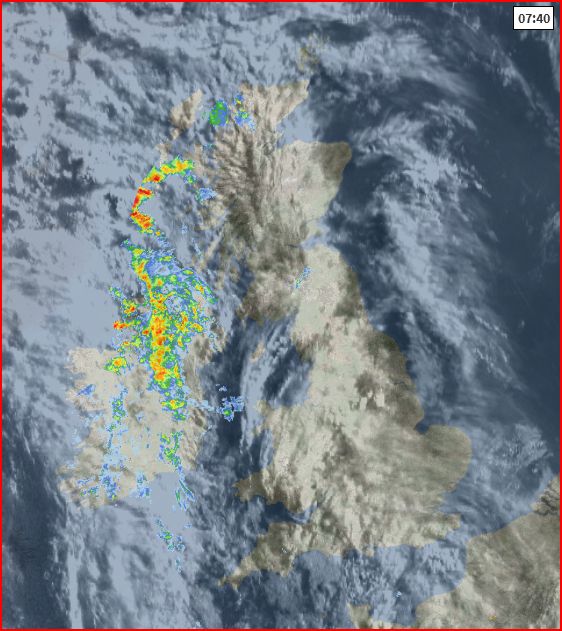
There is rain on the way from the Atlantic today and tonight, but many central and eastern parts it will remain dry today with the rain arriving overnight. The rain clears eastern parts tomorrow to sunshine and showers on Thursday and Friday. Tomorrow will be a warm day for England and Wales, but it will turn cooler on Friday, as an area of low pressure crossing the north introduces a northwesterly flow. The weekend starts cool and blustery with showers in places, but on Sunday it will warm up across the south while the north could get a soaking – as the remnants of Hurricane Gert pass to the northwest.
For now, clear skies overnight for many have meant temperatures have fallen into single figures in rural areas, so it’s a chilly start this morning for some, but also a dry, bright or sunny start for most too.
However, milder air with outbreaks of rain have already arrived across Ireland and N. Ireland and it will cloud over and turn increasingly windy from the west through the morning across western Scotland, NW England, Wales and SW England as this rain to the west moves into these areas by lunchtime. Central and eastern areas of England staying dry and bright or sunny for much of the day, but most parts of Scotland, Wales and western areas of England will become cloudy and windy through the afternoon, with patchy outbreaks of rain moving in, which will be heavy at times across western coasts and hills. Brighter, but showery conditions spreading in across Ireland and N. Ireland by early evening.
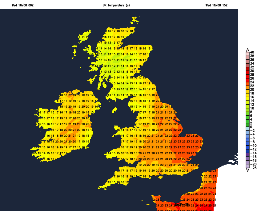
Warm where there’s brightness or sunshine, with temperatures reaching 19-21C, up to 23C across SE England and East Anglia. Where we see the cloud and rain in the north and west, temperatures reaching 16-18C.
Then we will all see some rain on Wednesday night, as it reaches eastern areas of England too, some heavy burst of rain developing across southern and eastern England into the early hours of Thursday, while showers and clear spells between spread in from the west across northern and western areas.
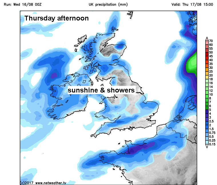
Some uncertainty over how quickly the overnight rain will clear East Anglia and SE England on Thursday morning, there could be some heavy rain to contend with for the morning commute in these areas, but the rain should clear out into the North Sea by early afternoon. Sunshine and showers following the overnight rain across most parts for Thursday, heaviest and most frequent across northern and western areas. A warm day for England and Wales, temperatures reaching 18-22C generally, SE England and East Anglia again the warmest part of the country – where 23-24C is likely. Across Scotland and N. Ireland, temperatures reaching 17-19C.
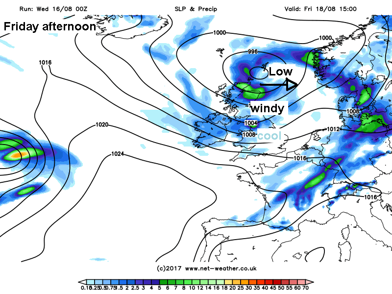
Perhaps a longer spell of rain and strong winds spreading east across central and northern parts on Thursday night as a deepening area of low pressure crosses northern areas, rain clearing northern England and southern Scotland by early afternoon but remaining windy across northern areas, with gales developing across eastern coasts as winds turn northwesterly. Otherwise, many areas will see a day of sunshine and blustery showers on Friday, locally heavy with hail and thunder. Southern most counties of England perhaps escaping with a mostly dry and sunny day. A cooler day as winds swing round to the northwest, top temperatures of 19-21C across SE Britain, 15-18C at best elsewhere.
A cool, blustery and showery northwesterly flow to start the weekend, showers becoming confined to eastern areas on Saturday afternoon, drier and sunnier further west.
For the second half of the weekend and the start of next week, weather forecasters are looking to Hurricane Gert, which is the other side of the Atlantic but some way east off the eastern seaboard of the U.S. This tropical system will remain a weak hurricane for a time before it is eventually swallowed up low pressure moving east out of Canada – then will form a deep Atlantic depression which will head towards Iceland by Sunday. The tropical air still wrapped up in this system may bring very heavy rain to northern parts of Britain on Sunday and into early Monday, with gales developing in the far northwest. Southern areas mostly dry, sunny and becoming quite warm again with temperatures reaching the low to mid-twenties.


