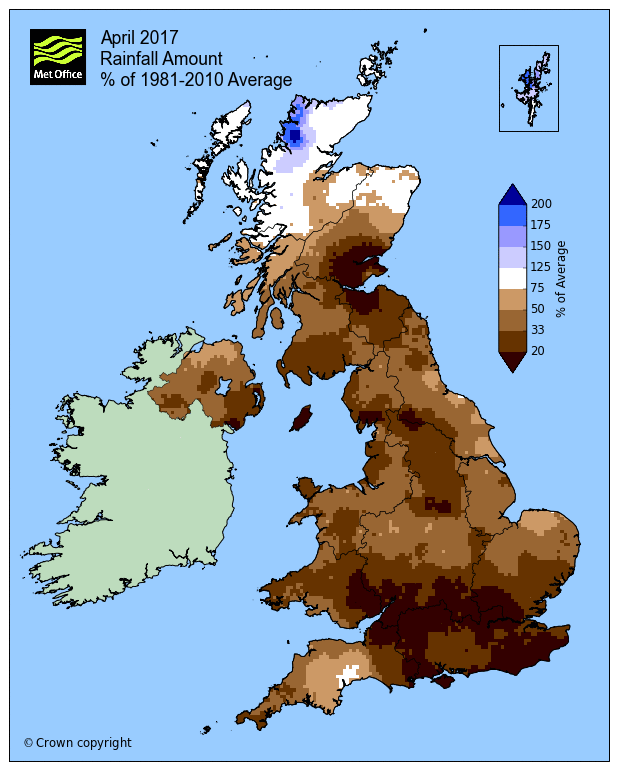
Following a dry winter, April 2017 was the 10th driest on record, with less than half the UK average rainfall.
April is often synonymous for its showers, but they generally stayed away for much of the month and it has been very dry across most of the UK apart from northern Scotland. April 2017 was the 10th driest on record for the UK as a whole, with less than half the UK average rainfall.
Much of southern England, SE Wales, NW England and the eastern half the central belt of Scotland has seen less than 30% of the 1981-2010 average rainfall for April.
From the Met Office “Statistics for April 2017”
Middlesex, Mid Lothian and Fife were the driest historical counties this month with just 12% of the rainfall expected in April. In comparison Sutherland was the wettest with rainfall 36% above average
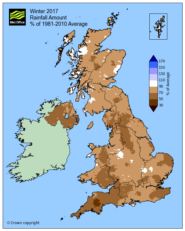
This follows a dry March across parts of southern England – which only saw around two-thirds of average rainfall and coming on the back of a dry winter across much of the UK and an October to March period across the UK which has been the driest for 20 years.
A dry winter preceded the dry April across much of the UK
There has been only one month in the last 10 months which has seen above average rainfall across SE England. This has led to dry soils, which has some farmers and growers concerned for longer-term prospects this year with regards to the growing season. And the continued lack of rainfall could mean water restrictions as we head through the summer when water demand for domestic, commercial and agricultural use becomes greatest. The dry conditions from the lack of rainfall last month even led to wildfires on some heathlands in Surrey and Hampshire.
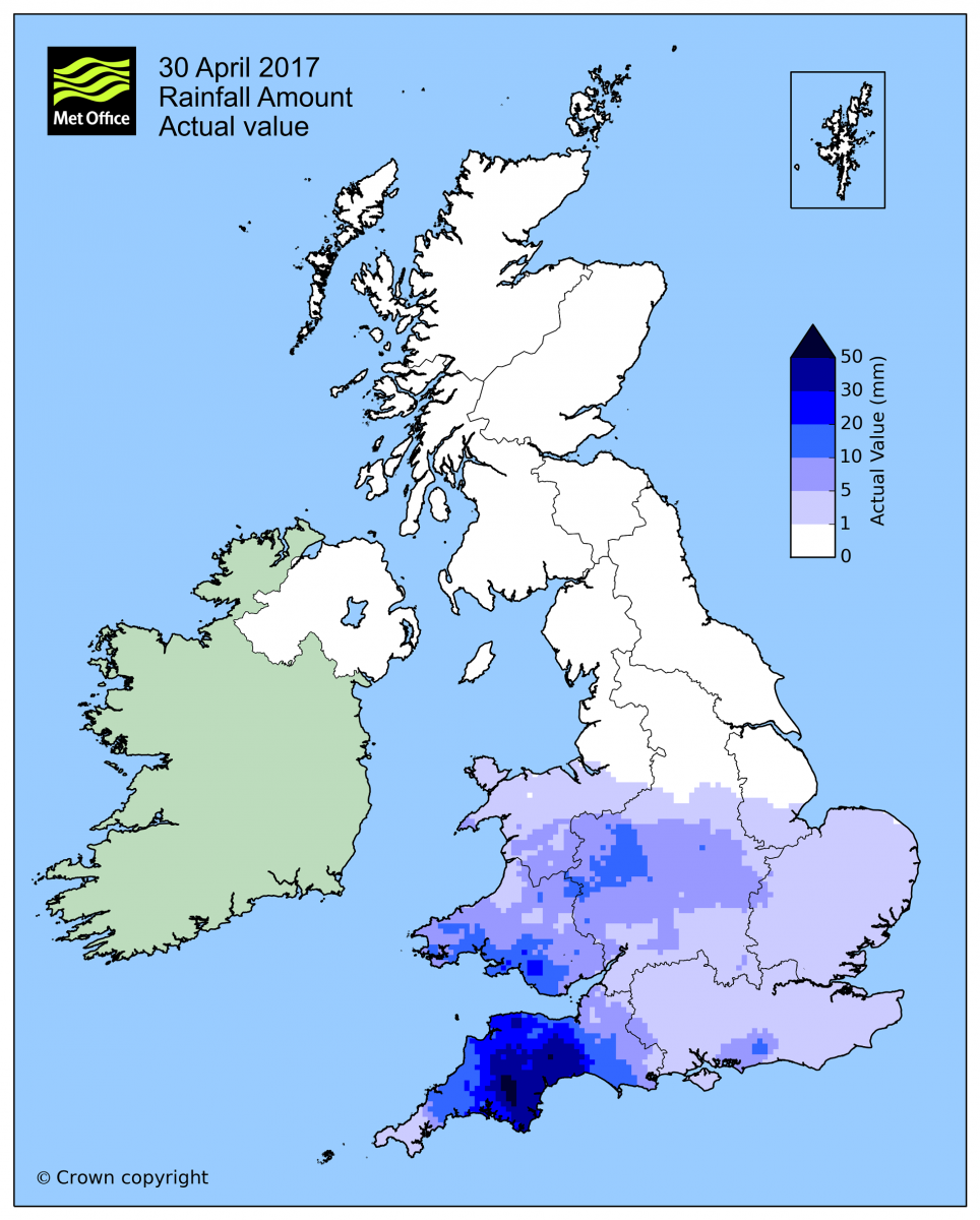
Much of southern Britain was exceptionally dry in April, though in an ironic twist, Devon saw 60% of its April rainfall fall in just one day on the last day of the month! The heavy rain that affected many parts of southern Britain over the Bank Holiday Weekend, particularly the 30th, pushed up the average rainfall total for the month. Had it come a day later, the monthly average rainfall figures would have looked even drier than they did.
April the 30th saw some heavy rain across the south, 60% of monthly average fell in a day across Devon
Spells of anticyclonic weather, where high pressure has been in charge, have dominated for months now, with any areas of rainfall moving in from the Atlantic, mostly from the west or northwest, generally weakening by the time they reach the south and east in particular. April was no exception.
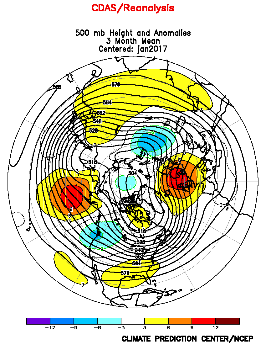
Anticyclonic pattern dominated the winter - as shown by height anomalies for Dec - Feb, orange/red means higher frequency of high pressure
However, as worrying as the statistics look – particularly coming on the back of a drier than average October-March, April can often be a dry month, as the prevailing southwesterlies that normally bring rainfall for much of the year tend to be most absent or erratic. Though some apprehension is probably already being felt in farming circles and the water supply industry should succeeding months continue the rainfall deficit. Rainfall over the ‘warmer’ months of May-October tends to have less chance of soaking into the ground, because it tends to evaporate or get sucked up by thirsty trees and other plants/crops before it gets chance to, unless the rain is very heavy and/or persistent.
There are different types of drought to take into account. A ‘meteorological drought’ could be statistically quantified when rainfall during a specified period falls below a particular threshold, say 50% deficit over 3 months or 15% over 2 years. Water companies will have different specifications for specifying a ‘hydrological drought’ – when winter rainfall fails to top up reservoirs, water course levels or underground aquifers following the usual deficit from the previous summer. Such a drought can extend over several years, if intervening winters are dry, even if the summers may be wetter than average. Farmers and other growers may look at drought differently, with an ‘agricultural drought’ tending to happen in the spring and summer months, when evaporation or transpiration from plants exceeds rainfall input. When this happens, without irrigation, plants are stressed, resulting in reduced, growth, yields and sometimes total failure.
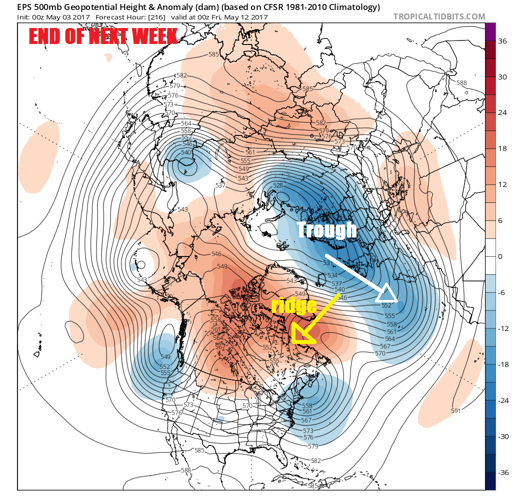
Apart from heavy showers across parts of southern England and Wales over the Bank Holiday just gone, high pressure close to the north is bringing dry and settled conditions to much of the UK. Southeast England and East Anglia will see more in the way of cloud brought in by a keen and cold northeasterly wind, thick enough to produce some light showery rain, but it will do little other than moisten the surface of the ground. For the rest of UK, high pressure looks to remain in control for the rest of the week, through the weekend and through the first half of next week, bringing predominantly dry and settled conditions. Hints from weather model operational and ensemble mean consensus of a change later next week, with low pressure becoming more established across NW Europe and the east Altantic, bringing more unsettled conditions, but still on the cool side.