
Blog looking at the risk of snow across higher ground of southern Scotland, northern England, N Ireland and Wales tonight and Friday morning.
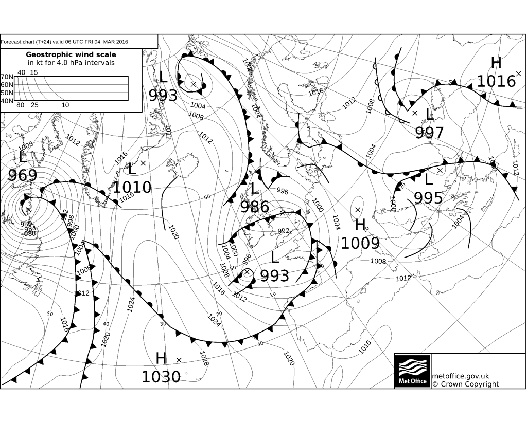
A low pressure system over the Atlantic will slide east across the UK tonight. A deepening area of low pressure on the northeast flank of the low pressure system crosses N and E England Friday morning. Associated occluded front will lie through this low, pushing a band of rain, sleet and snow eastward across England and Wales tonight.
Frontal boundary lies W-E across central UK at 12 noon on Friday
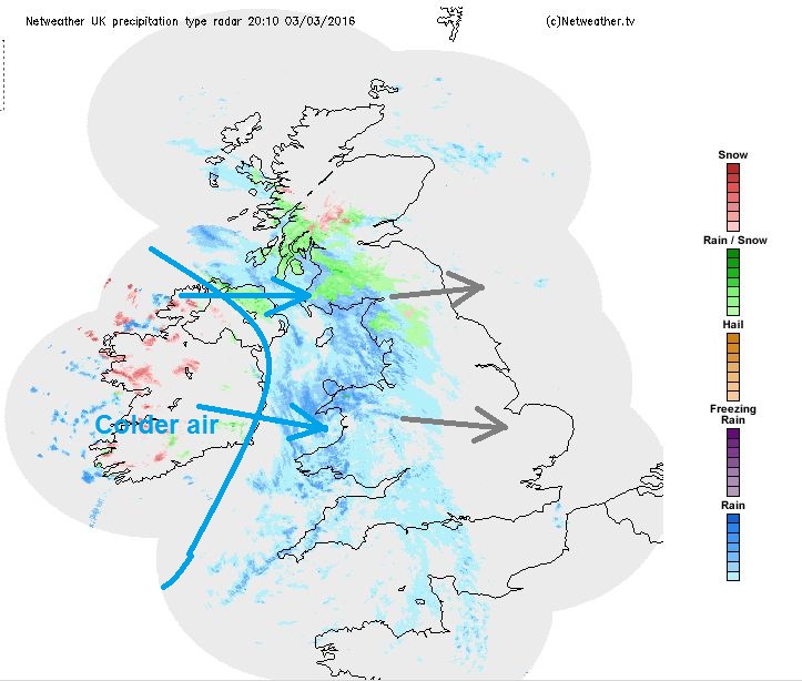
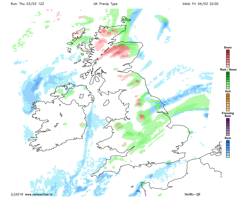
The front becomes slow moving and west-to-east aligned across N. Ireland, north Wales and N. England during Friday, as it pivots around the low moving east and exiting somewhere over Lincs or Norfolk in the evening. A pool of colder air, already across Ireland this evening, allowing showers to fall as snow inland, will spread east and engage the slow-moving frontal boundary, turning rain/sleet increasingly to snow tonight/early Friday.
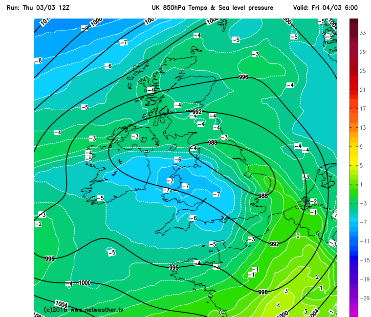
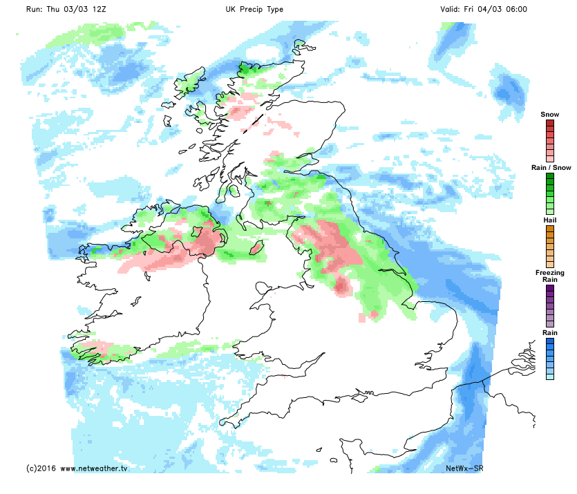
Area of low pressure across northern/eastern England 6am Friday morning, cold pool moving in from the west engaging rain/sleet and turning it to snow
The precipitation along the front is forecast to be heaviest tonight / early Friday morning as it pushes east across England, Wales and southern Scotland before easing in the afternoon. NMM, HIRLAM and ECMWF weather models indicate that snow will be most likely to fall and settle over higher ground of N. Ireland, southern Scotland, north Wales and N. England tonight into Friday morning, though heavier bursts could lower the freezing level through evaporative cooling, allowing snow to fall to and perhaps settle temporarily at lower levels of these areas away from coasts. GFS more generous with bringing snowfall to lower levels further south, but the model has a known colder bias, indicating snow when in reality it rains. Dew points and partial thicknesses (850-1000mb thickness) look knife-edge marginal for snow to fall to lower levels, so the heaviness of the precipitation will be crucial to whether snow or sleet/rain falls and could vary locally place to place at lower levels. Diurnal fall in temperatures overnight will also help lower the snow level too as winds fall light near the centre of the low crossing central UK. Further south, stronger westerly flow will likely keep the temperature too high from the Midlands south for snow to fall and settle at lower levels, Hence the Met Office removing the more southern yellow warning for snow and ice. Though some brief sleet or wet snow that doesn’t settle can’t be ruled out.
NMM keeps snow generally to higher ground of Scotland, northern England and Wales, though potential to fall to lower levels in heavier bursts, the precipitation mainly turning back to sleet/reain as it weakens and slips south in the evening.
So higher areas of N. Ireland, southern Scotland, N England, N Wales and perhaps parts of the Midlands above 150-200 m most likely to see snow overnight /Friday morning and it perhaps settling – with 2-5cm possible, more above 300m, with perhaps some significant local accumulations (10-15cm) over higher passes of the Pennines, Cumbrian Fells, mountains of N Wales and perhaps as far north as the Southern Uplands of Scotland. Where snow falls in heavier bursts at lower levels, a few centimetres are possible locally.
Also, western Ireland will see frequent sleet and snow showers tonight and into the morning, as colder air arrives here, bringing some local accumulations.
As the frontal precipitation eases and very slowly sinks south Friday afternoon, snow mostly turning back to sleet/rain away from the highest ground. Though it could be Saturday morning before the rain and hill snow clears N England and Wales, before clearing southern England and E Anglia Saturday afternoon.
A colder, brighter but showery northerly flow, (veering northeasterly for a time) follows on Saturday into Sunday. Showers of rain/sleet across southern UK, but falling as snow over higher ground of N England/S Scotland and perhaps to lower levels across northern Scotland – where significant accumulations are possible over the northern Highlands.
Another wave of low pressure drops S/SE across the western side of the UK Sunday evening/night. Some uncertainty over the track of the low, as 00z GFS was further east than 06z and 12z. Though most models now agree on the low dropping S/SE across Ireland then far SW of England. 12z ECMWF indicates snowfall for N. Ireland, Wales and the moors of SW England Sunday night and early Monday morning.
Turning milder across all parts from Wednesday, as Atlantic low pressure systems start pushing bouts of wind and rain east for the rest of the week. So make the most of any snow in the next few days, as it may not be back anytime soon thereafter.


