


Forecaster Blog - December likely to be mild for rest of the month, perhaps exceptionally so and a look at the chances for cold and wintry weather to arrive in the New Year.

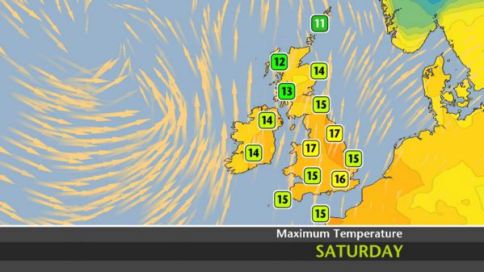
Need I say that winter UK has got off to a rather mild start these last few weeks, provisional figures from the Met Office up to mid-month (1-14 Dec) suggest that December temperatures have been 3.2C above average across the UK as a whole. Though this had hidden sharp north-south temperatures contrasts at times, with Scotland seeing colder conditions at times, with clear skies at night leading frosts. While further south, mild and humid air has prevailed keeping nights cloudy and mild. This December could be on course to be warmest in 100 years if current conditions continue. Thursday saw a few spots in southern England reach 16C+, London City Airport 17C - still shy of the date record of 17.8C set in Aber, north Wales back in 1972. But as the very mild conditions show no signs of relenting over the coming days, 16-17C is possible on Saturday and the date record is 15.5C, it’s only a matter of time that one or two date records are broken.
Maximum temperatures for Saturday (Image courtesy of the UK Met Office)
Although there will continue to be brief potential for hill snow in the far north in the next few weeks, as the jet stream dips south at times, the general pattern we are currently in, bringing unusually mild conditions, looks unlikely to change for the rest of the month. The current pattern, which dominated since late October, has seen persistent and strong westerly jet stream winds across the N Atlantic and NW Europe - which have forced a persistent area of high pressure over mainland Europe while a mean upper trough has persisted close the north and northwest of the UK on the cold side of the jet stream. Pressure has been persistently low close to the jet over NW Europe (including the UK), which has meant wet and windy conditions at times, but also generally mild to very mild. High pressure over mainland Europe has brought generally dry and settled conditions away from northern and western fringes and it’s been very mild too, with a lack of snow for the Alps.
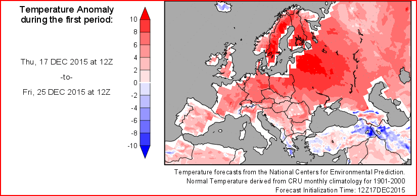
Forecast temp anomaly for Europe 17th - 25th Dec
The strong belt of westerly jet stream winds, not just across NW Europe and the Atlantic, but also across USA and the N Pacific is likely being driven by a very strong El Nino which is currently reaching its peak. The anomalously warm waters of the central and eastern tropical Pacific, that characterise El Nino, warm the air above which spreads north over the N Pacific and strengthen the jet stream further north over the N Pacific, due to the temperature contrast of colder air bleeding off eastern Siberia and Alaska to the north. The strong, flat and zonal (west to east) jet flowing downstream across the USA and the N Atlantic/N Europe effectively keeps deep cold polar air locked up within the arctic circle which helps maintain a strong Polar Vortex (PV). Also, the current westerly wind anomaly phase of the Quasi Biennal Oscillation (QBO) is maintaining the strong PV too. The easterly wind anomaly phase of the QBO tends to lend to a weaker PV, an easterly QBO was present during the cold winter of 2009/10.
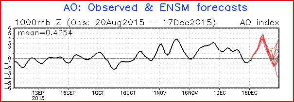
The PV has been strong throughout November and looks to remain so through the rest of December. The strength of Polar Vortex is measured by the Arctic Oscillation (AO) of which a positive index indicates low heights/pressure in the polar region and thus strong polar vortex, while a negative index suggests a weak or displaced PV. Current AO forecasts (below) are for it to go strongly positive (+3/+4) before heading more neutral, though on average the AO has been positive since late October.
AO: Observed and ensemble forecast
However, analogs indicate that generally a polar vortex that is strong to start winter often doesn’t remain so throughout winter. Furthermore, even though El Nino warms up places like USA and Europe in early winter, it also tends to increase wave flux activity towards the pole in the winter, i.e. waves in the flow transfer energy from the mid-latitude troposphere into the stratosphere at higher latitudes which can disturb the polar vortex and eventually weaken it, resulting in either the vortex being displaced equatorward across N America, or Europe, or Siberia; or the polar vortex splits with often two vortices dropping south. The breakaway from the pole of these chunks of cold stratosphere are usually in tandem with cold pools in the troposphere – leading to prolonged cold and snowy weather to parts of Europe and/or the USA. Displacement of the PV usually tends to occur mid-January onwards, while a split vortex occurs in February at the earliest. So on this occurring alone, we may be looking at a stratosphere change well into January. However, the troposphere pattern can change before changes in the stratosphere. For example, the winter of 1986-87 winter featured a strong El Nino with a mild December, then a stratospheric vortex displacement that didn't officially occur until Jan 25th '87. However, a pattern change occurred earlier in the month, which allowed a very cold and snowy easterly flow to establish for several days across the UK.
Sudden Stratospheric Warming in late January 1987 in a strong El Nino led to displacement of the Polar Vortex towards Europe
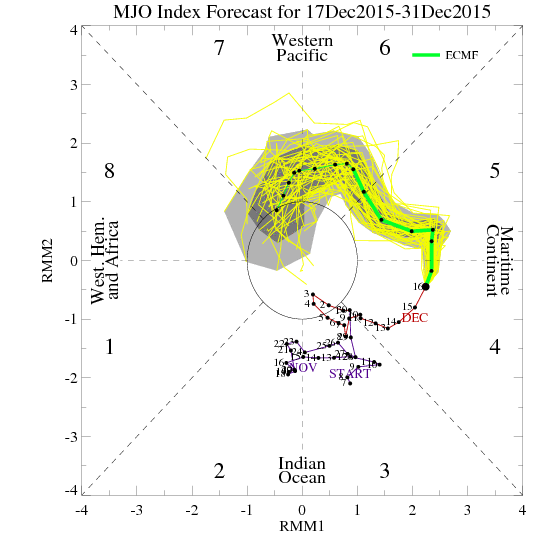
The potential weakening of the polar vortex later this winter may not be the only event that could drive a pattern change. There are other drivers that may change the tropospheric pattern for colder conditions before any potential weakening of the PV. The Madden Julian Oscillation (MJO) – a tropical convection disturbance which propagates eastwards over the global tropics over 30-60 days, generates distinct lower/upper level atmospheric circulations that can extend right around the globe. The MJO is normally suppressed during strong El Nino events, but some weather model forecasts have been suggesting for a number of days now a coherent/amplified MJO wave. There is debate whether this amplified wave could be linked with a Kelvin wave, rather than an actual MJO wave, but both may have similar effects depending where the wave is over the tropical belt of the world. There are 8 phases of the MJO, phases 7/8/1 are most likely to promote blocking and a greater chance of cold and snowy spells across Europe. ECMWF model has, for the last few days, been steadfast in driving the MJO in a moderately amplified wave into phase 7. This position of the MJO can lead to a more amplified/wavy upper wind/jet configuration, leading to a greater chance of blocking over N America, Atlantic and Europe, with the cold air locked up in the arctic allowed to spread south over one or all these areas.
ECMWF MJO Index forecast:
It remains to be seen whether the MJO forcing will be enough to overcome the El Nino background forcing to change the pattern. Otherwise, if a pattern change doesn’t materialise from MJO forcing, there is uncertainty whether further likely wave activity against the very strong polar vortex will be enough to weaken to displace it and perhaps eventually split it. It may not be until February we see this occur or it may not happen at all. There is a decent chance it will occur, based on analogs of past winters with early strong El Ninos that peaked in December. But there are various other atmospheric drivers, other than El Nino this winter that maybe different this winter to what they were back in those analog years with Ninos that peaked at similar times. Such drivers are the Quasi Biennial Oscillation - which is in an unfavourable 'westerly' phase which promotes a strong Polar Vortex. Also, we are just coming down from a maximum in Solar Activity, cold winters often co-incide with a minimum in solar activity.
So, it’s only an educated guess to whether we will see cold and wintry conditions in January and/or February. But my money’s on December being mild throughout and probably one of the mildest if not the mildest of all time. Could also be one of the dullest, and in parts of the west and northwest, the wettest, for a while.


