


Very mild week for all, particularly from mid-week with date records possibly broken. Cooler but still unsettled next week, perhaps cold at times in the north with risk of hill snow towards Christmas Day.
Mild week ahead – perhaps record-breaking mildness again?
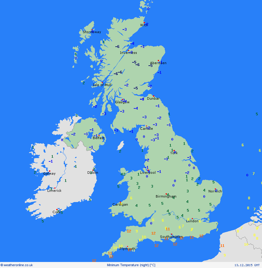
An Atlantic storm brought a spell of heavy snow to northern England, parts of Northern Ireland and Scotland on Saturday morning, bringing travel disruption to parts of NE England. It eventually turned milder through the day from the south over northern England, but the cold air lingered further north over Scotland into Saturday night, with clearing skies leading to temperatures falling to -7.3C at Kinbrace in the Highlands of Scotland. The mild air hung across the south though, which lead to quite marked temperature contrasts across the UK (image courtesy of Weatheronline):
The cold air lingered on through Sunday night across Scotland, with temperatures falling below freezing, so as the warm front pushed the rain north it turned to snow as it hit colder air ... this time further north across much of northern Scotland, and there were even reports of freezing rain where air above freezing moved above air below freezing allowing rain to fall to ground but freezing on impact.
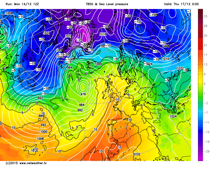
However, this is the last we are likely to see of any wintry weather for the rest of this week, as high pressure builds to the east and low pressure stays close out west, drawing in a very mild south to southwesterly flow which has its origins over the sub-tropical north Atlantic as far south as Madeira.
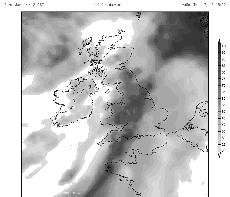
Last Monday saw the warmest 7th December ever, when Gogerddan in SW Wales saw 16.4C, Tuesday 8th and Wednesday 9th saw temperatures again in the mid-teens across southern and western parts. This week again we could be looking at temperatures creeping up towards the mid-teens by mid-week – which may break some date records again. It won’t necessarily be sunny though, despite the very mild temperatures for the time of year, this is thanks to the southwesterly flow being rather moist. In fact, there has been a real dearth of sunshine generally, not just this month so far, but November was the dullest on record (since 1929) across the UK, the second dullest for England, due to a generally humid and cloudy southwesterly flow dominating much of the month.
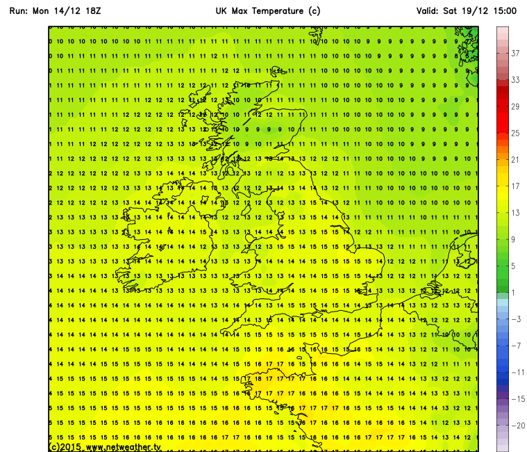
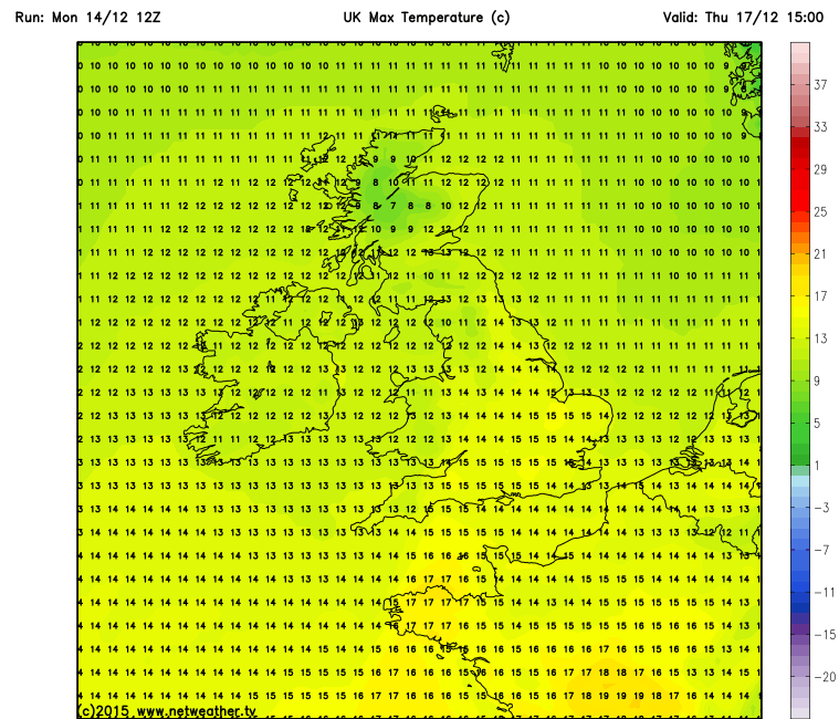
So despite the mildness this week, sunshine will, again, be in short supply. A look at the GFS temperature projections, it’s an average start to the week temperature-wise and it’s really Wednesday and Thursday that temperatures look to hit the mid-teens. The warmest 2m temperatures are projected across the south, but the strong southwesterly wind on Wednesday 16th and Thursday 17th across northern and western areas may raise temperatures into the mid-teens or more to the lee of high ground through the Foehn Effect. The date records for maximum temperatures for the 16th (17.0C) and the 17th (17.8C) both in December 1972 at Aber, Gywnedd in north Wales – to the lee of Snowdonia. We have some way to go to get near these temperatures though based on current projections, but it can’t be totally ruled out. Saturday 19th also looks very mild, perhaps even milder than Wednesday and Thursday. The date record for the 19th of 15.5C at Hemsby in Norfolk in 1993 may well be broken on Saturday.
Cloudcover on Thursday
Max temperatures on Thursday
Max temps for Saturday:

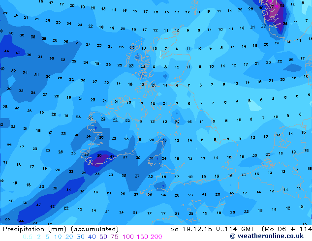
Rainfall
There’s more rain on the way this week, but with weather fronts moving through fairly quickly rather than stalling, we are unlikely to see anywhere near the amount of rain we saw the Saturday before last or even last week. 00z GFS indicates 20-35mm ( 1 inch+) across western parts of mainlaind UK including Cumbria during this working week, more over Southern Ireland. Spread out over 5 days this is much less than the 200mm+ seen in 24 hrs back on that Saturday before last!
Christmas week weather
The unsettled conditions look to continue through next week too, with fairly high confidence from NWP output for lower geopotential heights and pressure to the NW of the UK over Greenland and Iceland and strong westerly jet stream all driving a cyclonic westerly or southwesterly flow across the UK. There are some waves in this strong upper flow, so mild Tropical maritime air will alternate with colder Polar martime air, though the Tm air will tend to dominate most the time. This opens up the potential for colder Pm airmass incursions with a risk of snow (in the north) during the Festive Period, including Christmas Day. The 25th December is still 11 days away and thus too far off to forecast snow falling, but if it is cold enough, snow will most likely be confined to the north of the UK in the westerly flow likely. Given the strong jet stream, steep temperature gradient and a number of shortwave troughs moving in the flow, there is potential for one or two deep low pressure systems that could bring severe gales or storm force winds, so one we'll keep a close eye as many people will be travelling.
No pattern change looking likely for the rest of the month
Although the potential for hill snow and perhaps snow falling occasionally to lower levels in the north will increase next week and the week after, as the jet stream dips south at times, the general pattern we are currently in looks unlikely to change. The current pattern which has dominated since late October, has seen a persistent area of high pressure over mainland Europe (bringing unseasonably mild temperatures to much of western and central Europe and little snow for the ski resorts) and a mean trough close the north and northwest of the UK – bringing mostly mild southwesterly winds. Though with occasional Polar maritime incursions, as winds veer northwesterly behind depressions moving east, cold enough for hill snow across Scotland and N England.
A strong polar vortex in the stratosphere and troposphere has and continues to drive a strong and tight belt of westerly winds around the northern hemisphere keeping the cold air locked up generally within the arctic circle. The polar vortex has been strong through November and forecasts are that it looks to remain so through the rest of December, so it is unlikely we will see any major pattern change to a more ‘blocked’ pattern, whereby colder conditions become more sustained than mild, until well into the New Year.
Some hints that we may see a pattern change in the New Year, as generally the Polar Vortex tends not to remain strong all winter and also some forecasts for a coherent wave of the Madden Julian Oscillation (MJO) moving towards a favourable phase for blocking later this month ... more on this in another blog on Tuesday.


