


Storm Abigail is set to batter NW Scotland, next up is Kate, an ex-hurricane who could bring a lot of rain to Wales and W. Britain this weekend
Abigails winds set to bring disruption in Scotland but ex-Kate's rain could cause flooding for England and Wales this weekend
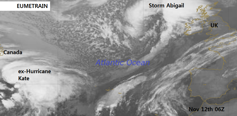
Storm Abigail is closing in on NW UK, bringing severe gales to NW Scotland gusts up to 90mph, strong winds, large swell and waves, squally rain and gusts around 60mph for N.Britain and coasts of N.Ireland.
Abigail is the first named storm in a trial for this season from UK Met Office and Met Eireann. The next storm to cause disruption to the UK or Eire would get the name Barney. Unless, the low pressure already has a name because it was previously a tropical cyclone.
Tropical Depressions/Storms or Hurricanes from the western Atlantic sometimes make their way across the Atlantic and bother the UK and/or Eire. Post tropical cyclone Kate, was previously Hurricane Kate and now is an extra-tropical storm in the mid Atlantic.
The UK Met Office have Amber and Yellow warnings out for Abigail's winds but also now Yellow warnings for Heavy Rain.
Conwy in NW Wales aas already seen a very wet week and this coming weekend could bring more heavy and persistent rain to western Britain. NW Wales and NW England look most prone, with SW Scotland and rest of W.Wales also at risk. Any system with tropical air entwined in it has the potential to bring large rainfall totals. Forecast models seem to show a continaul feed of frontal rain lining up over Ireland acorss the Irish Sea, over a central swathe of Britain.
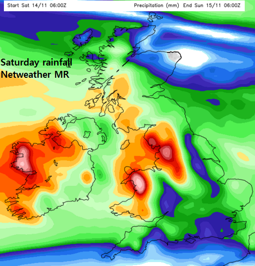
White and red areas show 24 hour rainfall totals of 40 to >60mm Sat 14th Nov
The environment Agency do have warnings now on their 3 day ahead page.
"There is a LOW flood risk over the weekend for North Wales and the northwest of England, with continuous rain expected to fall over already wet areas, resulting in both river and surface water flooding. There is a low likelihood of some communities being partially flooded, significant disruption to travel including closure of some roads, and a possible danger to life from fast flowing and deep water."
Areas on the map also include NE England, and the Midlands (Notts and Derbys). Some areas already have saturated ground, so flooding seems likely, either from standing water or rivers bursting thier banks
Flood warnings - Environment Agency
SEPA already for Solway Firth 12/11 12Z


