
Synoptic Analysis - Brief heat for the SE on Saturday, then a wet and stormy breakdown Sunday through to Monday.

Hot sunshine, flooding, thunder and lightning, hail and even strong winds … yep, that’s what parts of the UK may see this weekend. Such volatile weather befitting of our summer holidays and it’s a week too early to affect an August Bank Holiday weekend too, but more on Bank Holiday prospects later!
What’s happening on a synoptic level this weekend is quite a complex evolution, which is prone to error from weather model output, so some caution needed even this close to giving too much detail on a local level.
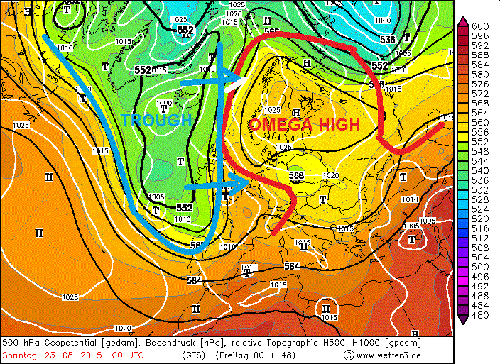
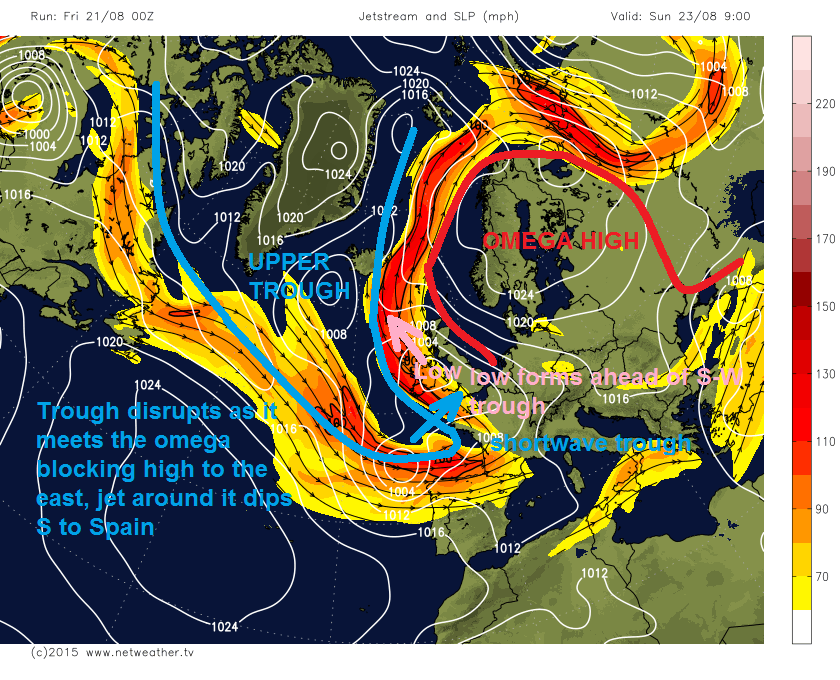
An upper trough that’s been sat to the west of the UK over the last few days tries to push east this weekend, but comes up against a omega-shaped blocking high pressure system to the east/northeast over Scandinavia. This block causes the trough to ‘disrupt’ and become ‘negatively-tilted’, i.e. trough axis becomes NW to SE aligned, rather than N-S aligned as it is now. And the jet stream rounding the trough also buckles and dips south towards Spain.
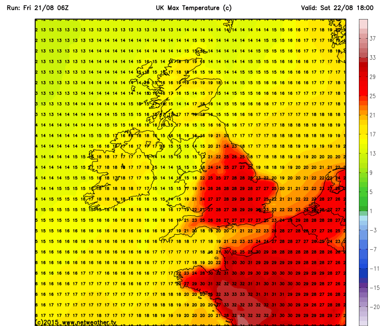
This will mean the wind will back from southwesterly to a deep southerly flow ahead of the disrupting trough and jet stream which becomes slow-moving to the west, so hot and humid air over the continent gets dragged north across central and eastern parts of England on Saturday. So we could see temperatures reach the high 20s across SE England, E Midlands and East Anglia in the sunshine here, perhaps 30C somewhere in the London area. But as we’ve seen before this summer, the flirt with mainland Europe’s heat is all too brief and localised to the southeast, thanks to the jet stream and low pressure systems close to the west, so it turns cooler again on Sunday for the small chunk of the UK that benefits from the heat tomorrow.
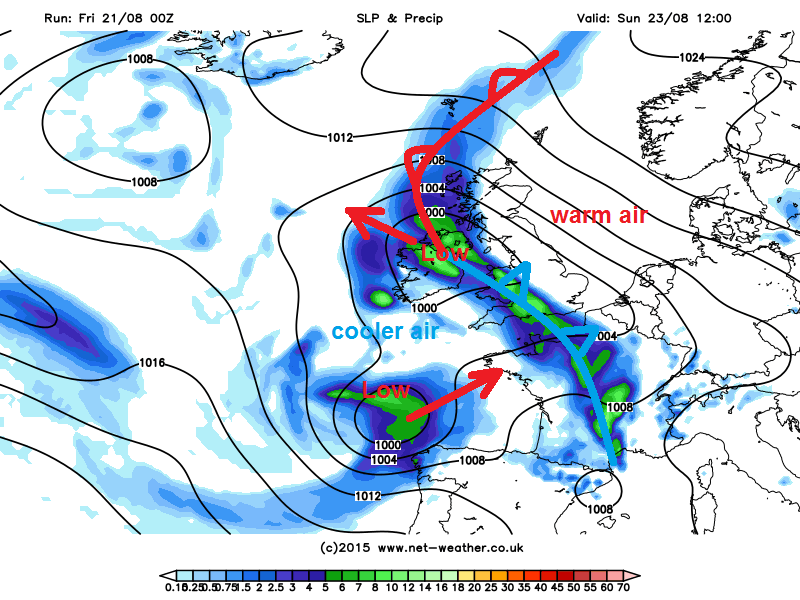
The frontal zone looks to lie from SW England northeast across Wales and northern England then out into the North Sea for much of Saturday. So these areas likely to see pulses of heavy thundery rain and thunderstorms moving NE along this front for much of the day. Some large rainfall totals are indicated by models from these thundery downpours and given the frontal zone will be slow moving ove northern and western parts, there is a risk of localised flooding. The frontal zone then begins to tilt from a SW-NE alignment to N-S then SE-NW alignment heading through Saturday night into Sunday, as the upper trough disrupts and becomes more SE-NW aligned.
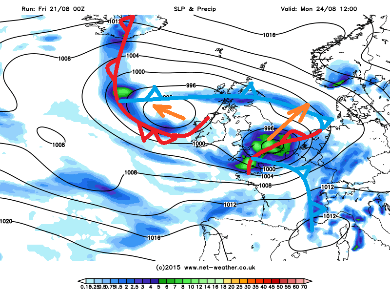
A short-wave trough rounding the base of the upper trough moves NE towards S England Saturday evening, creating ascent ahead of it, inducing a wave in the frontal zone and cyclonic circulation at the surface. So a shallow surface low is modeled to form along the frontal wave somewhere over NW France or the western English Channel Saturday night. The low moves N then NW across western UK then across to Ireland on Sunday following the 500mb flow which becomes increasingly backed from southerly to southeasterly as the upper trough disrupts. The frontal zone pivots as the low moves NW, so that a cold front pushes northeast across England and Wales, while further north a warm front pushes west across Scotland out into the Atlantic.
Eventually the cold front clears north across Scotland and out into the North Sea further south on Monday, as the low tracks west from Ireland out over the Atlantic. We then see a further complication of another low that develops on the rearward side of the upper trough to the SW of the UK Sunday evening under the left exit of a strong equatorward jet on the rear side of the upper trough. After some disagreement, models now take this low northeast across northern France then SE UK as a fairly deep depression (00z GFS has low at 991mb over East Anglia Monday afternoon) – with some strong winds through the English Channel and over northern French coasts (GFS has 35-45mph sustained and 50-60mph gusts through the Dover Straits Monday afternoon). So this could cause some disruption to cross-channel ferries. ECM slightly further south in track with strongest winds over northern France. Both GFS and ECM bring some large rainfall totals with passage of this low across central and eastern England.
It remains unsettled and windy at times for the rest of next week, as the blocking high over Scandinavia slips away and the upper trough to the SW de-amplifies then moves across northern UK with a strong southwesterly jet stream blasting across the UK for much of the week, sending a series of low pressure systems or frontal waves across the UK bringing spells of wind and rain interspersed with showers, which maybe thundery.
The late August Bank Holiday Weekend prospects are a little too far off to forecast accurately for now, but at the moment, ECMWF and GFS suggest an unsettled start, with low pressure over northern UK on Saturday bringing sunshine and showers, but the low then moves away east to allow high pressure to build in from the SW, so perhaps drier and more settled prospects for Sunday and Bank Holiday Monday.


