


A look at the weather across mainland Europe for the first week of August, heat building with very hot conditions across many parts by the end of the week away from the UK and Scandinavia.

Following an intense heatwave gripping much of Spain during July, some relief came to northern and eastern areas of the country on Friday, as an area of low pressure formed under an upper disturbance to allow thunderstorms to develop. The storms brought some welcome rain and cooling off, and even some very large hail in a few spots, with tennis ball size hail photographed near Alicante in Spain. This thundery low/trough then drifted east across the western Mediterranean over the weekend, bringing storms across the Balearics and southern France Friday night and to Italy during Saturday and Sunday and now bringing storms across Balkans and Greece too to end the weekend.
Ridge rebuilds over southern Europe following thundery trough bringing storms over the weekend and now moving east towards SE Europe:
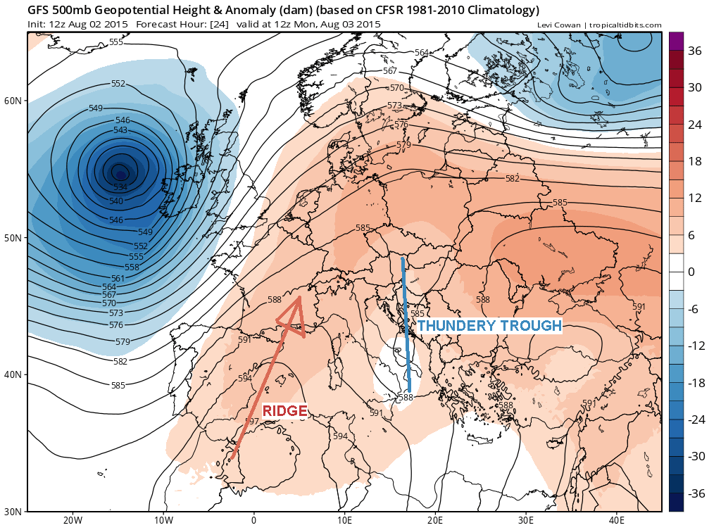
The trend, though, is for an upper ridge of high pressure to rebuild north across southern Europe following this disturbance clearing east, with the heat rebuilding and dry conditions returning on Sunday and into the new week. Temperatures Sunday afternoon reached as high as 38C inland across southern Spain , 35C in southern Italy, 33C in the north of Spain and SW France, with the low 30s now as far north as the Paris Basin in northern France along with eastern France, SW Germany, Switzerland, northern Italy and the Balkans.
Heat builds up from the south across mainland Europe early next week, hot air dragged north by low pressure over NW Europe
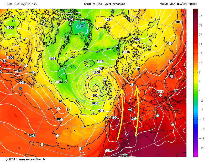
The heat builds across mainland Europe early next week, as a deep area of low pressure to the west of Britain draws a deep southerly flow across much of Europe. Across southern Europe, intense heat will return to Spain on Monday and Tuesday, with inland highs of 40C likely in Seville, 36C in Madrid. Further east into Italy, mostly dry, sunny and hot with temperatures reaching as high as 35C in Florence, 33C in Naples, a risk of a few thunderstorms developing inland over the mountains. For the beaches of southern Europe, we are looking at staying dry and sunny with highs of 30-33C for the Portuguese Algarve, The Mediterranean Costas of Spain, the Balearic Islands and The French Riviera. Across Italy 28-30C in the coastal resorts. The Adriatic coasts of The Balkans and Greece pretty hot too, with costal resorts reaching 32-35C Monday and Tuesday. Extremely hot the next few days in southern Turkey and Cyprus with up to 39C in Antalya and 42C in Cyprus.
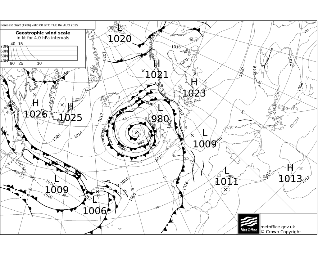
The heat over southern Europe extending north across France and Germany on Monday, with 35C as far north as Paris on Monday, 34C in Cologne and Frankfurt. However, a cold front passing through the UK on Monday will introduce cooler and fresher conditions across much of France and western Germany on Tuesday, some heavy thundery downpours developing as this transition to cooler conditions occurs. The heat hanging on across SE France though.
Front introduces fresher conditions off the Atlantic across France and Germany on Tuesday:
It remains very hot and dry across much of Iberia for the rest of the week, away from the NW, with highs expected of 41C in Cordoba, 38C in Madrid. Along the Costas of the Mediterranean and the Balearics we are looking at highs of 30-33C. Perhaps an isolated risk of a thunderstorm over northern Spain. Heat builds again over France and Germany from Wednesday and becoming mostly dry too, after the thundery break own on Tuesday, temperatures back into the low to mid 30s across much of France and western Germany, perhaps as high as 36-38C over central France. Risk of showers or storms for western France late in the week though, as low pressure moves in from the west. The heat over France perhaps clipping SE England and East Anglia on Thursday and/or Friday, bringing highs back into the high 20s after a cool down on Tuesday and Wednesday.
Much of mainland Europe gripped by temps in the mid-to high 30s later in the week:
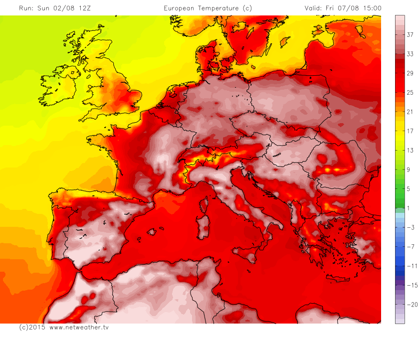
It turns even hotter across Italy later in the week, afternoon temperatures widely in the low to mid 30s, perhaps as high as 38C in inland cities such as Florence and Milan. Little sign of rain to bring any relief from the heat, with some very warm nights likely. Greece stays mostly dry and sunny for the rest of the week, with highs of 31-35C generally. Perhaps not quite as hot as early in the week, but southern Turkey still managing to reach the mid-30s, Cyprus though still close to 40C.
Away from the popular summer holiday destinations of southern Europe, central Europe remaining hot and becoming very hot during the coming week, highs of 30-31C Poland, Czech and Slovak Republics, Austria along with Hungary early in the week, creeping up to 33-36C later in the week. Much of Scandinavia, as well as the UK, cooler and unsettled for much of the week, with highs of the high teens in northern Scandinavia to low 20s in south.


