
Whilst southern Britain waits for a "mini heatwave", further north won't be as warm and parts of Scotland will be decidedly wet, with some flooding issues.
When talk starts of heatwaves and temperatures reaching 20C/25C/30C on the front pages of newspapers, everyone in the northern half of the UK knows not to assume this applies to them. N.Ireland, Scotland, north Wales and northern England might hope for some sunshine and temperatures a few degrees above average but the hype doesn’t often apply to these areas. Sometimes, it doesn’t apply to anyone in the UK at all but we’ll leave that for today.
If you are holidaying in Scotland, there might be the choice of east or west. Climatologically, eastern parts are drier but the west has the dramatic landscape. The west coast has the milder Atlantic waters and the Gulf Stream, whereas the North Sea is currently chilly at 6 or 7C. Many a day, the Haar (sea fog) has brought me a grey chill to eastern Scotland in a nippy NE wind whilst the west basks in glorious sunshine. Recently, NE Scotland has done well with the temperatures (top UK temperature this year is 20.7C in Aberdeenshire) thanks to the Fohn effect over the Grampians in a brisk SW wind and this may help the temperatures on Tuesday to rise to middling 15C. If you are enjoying a break in western Scotland this week, as Easter holidays continue for some schools, there will be more rain.
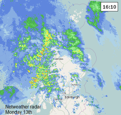
It’s already wet, see radar image from Monday afternoon. Current radar here
The rain has already set in on Monday from a warm front (which will introduce the higher temps. down south). The following cold front is going to wave about through Tuesday bringing more and more rain and only shifting southwards during Wednesday.
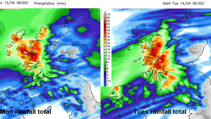
Netweather forecast rainfall totals for Monday and then Tues below. you can see some areas are receiving 40-50mm of rain both days (50mm being 2" rain). Wednesday will still have showers from the NW with up to 10mm falling.
There is already a flood warning in place from SEPA (the Scottish Environment agency) for Isle of Skye and Lochaber. More may follow. There will be localised flooding and tricky conditions on some roads but heavy rains in these parts can affect rail services and cause landslides. Keep in touch with @TrafficScotland for all the up to the minute information.
Easing on Wednesday, it does then look drier, hoorah! Not that warm but no longer soggy. High pressure builds over Scotland from Thursday onwards, spreading to the whole of the UK and lasting right through the weekend.


