


Latest Synoptic Analysis - an increasingly unsettled and sometimes disturbed weather pattern for the last 10 days of February
Like yesterday, high pressure close to the south will bring mostly dry, sunny and settled conditions across southern and eastern areas today. However, the high pressure system will move away to let in a lot more active and changeable weather pattern as we see out the last 10 days of February. The jet stream is currently to the north of the UK, with a ridge of high pressure extending from the Azores across much of Europe over the last few days, bringing mild conditions. But we will see the jet begin to sink south as a broadscale upper trough sinks SE across the Atlantic and into Europe during the rest of this week and into the weekend, dragging colder air south with it.
This change is already afoot to the north of the UK today, as we see a deep area of low pressure out across the far north Atlantic approaching Iceland. This huge low pressure system will strengthen the southwesterly wind to gale force across the north today and push weather fronts in from the west bringing cloud and rain to northern and increasingly western areas, while southern and eastern England stays dry and sunny.
A cold front will shift slowly southeast across the UK on Thursday, taking with it the windy conditions with cloud and rain across England and Wales, to be followed by colder, clearer and showery conditions across Scotland and EIRE/N Ireland, with some snow over the Scottish mountains.
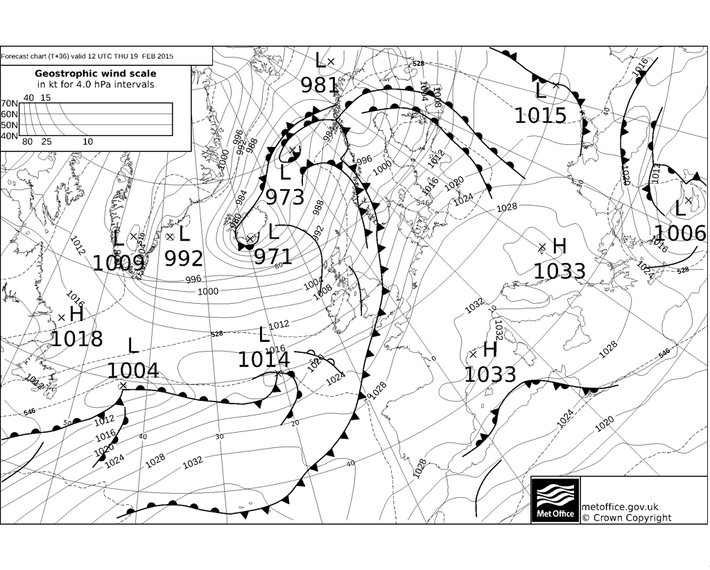
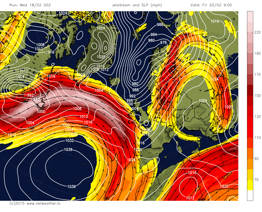
We then see a secondary area of low pressure form mid-Atlantic on Thursday (i.e. southwest of the parent low over the Norwegian Sea). There is some uncertainty over the track and depth of this low as it arrives across NW Europe. 00z ECMWF most developmental, with the low moving east and deepening to around 980mb centred near Cherbourg Penninsula (N France) at 18z on Friday before filling as it moves across the Low Countries. It brings an area of heavy rain and gales wrapped round it across S Ireland, England and Wales. UKMO fax charts more complex, with a 999mb low across southern England at 12z on Friday which then tracks ENE across the south N Sea, with a shallower low further SW moving into western France. 00z GFS similar to UKMO fax - with a 1004mb low moving across southern coastal counties of England Friday morning - bringing a spell of heavy rain across south Wales, southern, central and eastern England. The low forms on the forward side of a short-wave trough that moves out of NE Canada today and rides towards southern UK near or in the developmental left exit region of a strong Atlantic jet streak, GFS/UKMO perhaps not phasing the low with the shortwave trough and left exit of the jet so well as ECMWF. We will perhaps not know the more likely track or depth of this low until Thursday. But nevertheless, it will likely be an unpleasant day across parts of England and Wales on Friday. With cold air just to the north of the low, risk of some snow on the north edge of the rain area over northern hills. Brighter with wintry showers across Scotland.
Friday's low - as per 00z GFS - towards the developmental left exit region of a powerful Atlantic jet streak:
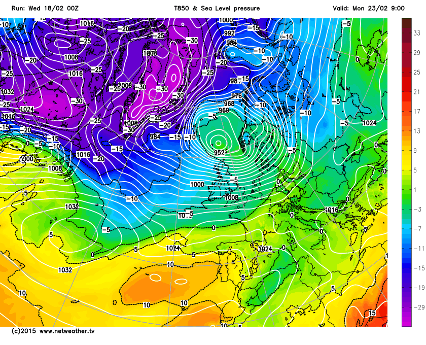
Northerly winds follow on Saturday as Friday's low across the south clears away east, so a cold and bright day, with some wintry showers bringing some hill snow across Scotland and some northwestern areas elsewhere. All change again on Sunday though, as we see the next low pressure system out in the Atlantic push weather fronts in from the west, bringing in milder air, strong winds, cloud and outbreaks of rain across most parts by the end of the day. Colder and clearer conditions pushing in across Scotland with sleet and snow showers, especially over hills. Winds could become very strong across the north Sunday night into Monday morning, with GFS, UKMO and ECMWF indicating a rather deep area of low pressure moving east between Iceland and Scotland.
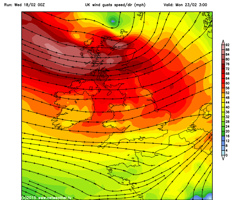

A strong and cold polar maritime airmass spreading across all areas on Monday and perhaps lasting through Tuesday too. Frequent sleet and snow showers look possible for Scotland, driven in by a gale or severe gale force northwesterly wind, though wind perhaps easing through Tuesday. Bright with wintry showers further south, though snow confined to higher ground. We could see a secondary wave or depression move across central or southern UK by mid-week, bringing rain across England and Wales, with a risk of some snow on its northern edge as it bumps into the colder air in place. Staying unsettled from mid-week next week, with another deep low pressure system perhaps approaching the UK, most likely going between Iceland and Scotland, but bringing wet and windy weather across all areas, with severe gales in the north. Followed by colder, clearer but showery conditions to end the week and into the weekend, showers wintry in nature with snow for northern hills.


