


Latest synoptic analysis - looking in more detail at the current cold and wintry spell which looks to last well into the first week of February.
In case you haven’t noticed, it’s turned a lot colder over the last 24 hours and it will stay cold into next week too, with many places seeing some snow over the coming days and risk of some significant snowfall in places. Although it will be cold enough for snow – the cold won’t be severe for many (unless you live up a mountain) so it looks unlikely that many will see sub-zero daytime temperatures, though we will see widespread frosts and a risk of ice.
Plenty of snow showers packing in across western areas this morning, as they have done all night, bringing as much as 6 inches (15cm) across parts of Scotland and Northern Ireland. Some of these showers filtering east this afternoon too, though tending to fall as a mix of rain, sleet and snow across the south, falling as snow in the heaviest showers, even to lower levels. Tonight there is a little uncertainty with regards to extent of more organised band of sleet and snow along a surface pressure trough/occlusion moving SE. Most models guidance suggest arriving across N Ireland this evening, before spreading south across NW England, Wales, The Midlands, SW and S England. The uncertainty concerns the eastern extent of this sleet and snow, 00/06z GFS further east than 06z UKMO and 00z ECM.
Slightly less cold tomorrow, so further wintry showers likely across many parts falling mostly as rain/sleet away from higher ground. But winds veer northerly over the weekend, dragging much colder air down from the arctic regions. It will be a showery northerly flow, with one or two fronts or troughs moving south on Saturday with the increasingly cold northerly flow – which could bring more organised bands of sleet and snow south. We will generally see a ‘wishbone’ effect on Sunday, where northern Scotland, Northern Ireland and north facing coasts elsewhere seeing the sleet/snow showers, drier and clearer skies inland, but we can't rule out un-forecast troughs/fronts in the flow bringing showers further inland too.
Into Monday, models have been consistent in indicating a low moving away from the eastern seaboard of N America on Saturday then moving over the top of the north Atlantic ridge toward Greenland before sliding SE toward the UK by Monday. However, the models differ with the track by several hundred miles. The jet stream driving this low's track arches over Greenland before diving south across EIRE and the Bay of Biscay/W France. Modelling surface lows and the upper flow up towards Greenland with more sparse data up here could lead to some difference by a few hundred miles in track which can make a big difference to the outcome over the UK. 00z ECM poses the highest risk with a track further east (and slower) than 00z UKMO and 00z GFS. ECM EPS mean looks further east too. 06z GFS just out has shifted the low further east in track now.
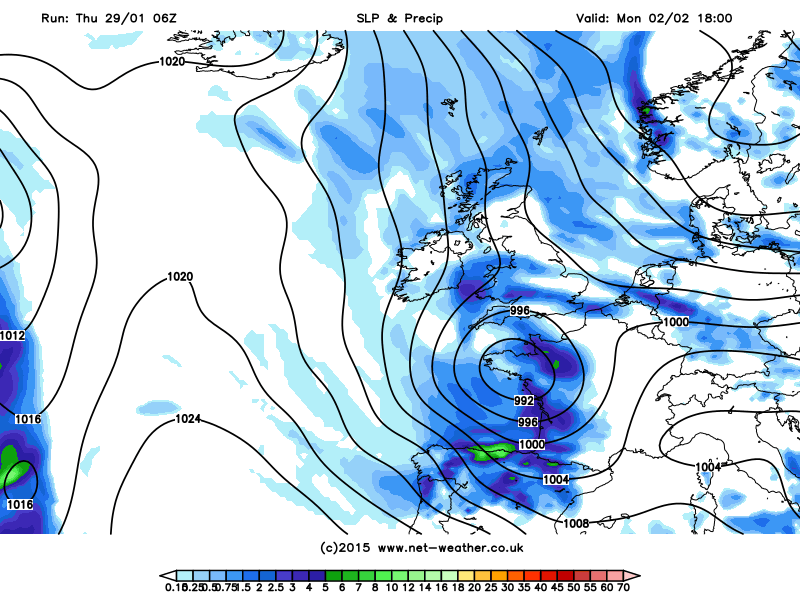
06z GFS shows low moving SE along the jet stream over western Ireland and on into NW France on Monday, bring risk of sleet and snow on its northern flank across southern Britain:
So will be interesting to see who comes out top with the track of this low and also the other features running south or southeast that could bring more organised areas of sleet/snow away from the favoured northern and western areas that benefit from showers over the next couple of days.
So sleet and snow perhaps affecting western and some southern areas later on Monday, as that low drops down across western areas, clearing south Tuesday morning to further wintry showers near coasts for the rest of Tuesday and Wednesday. 00z ECM and 00/06z GFS indicate the northerly flow fading towards the end of next week, as high pressure builds in from the west and the trough/lows to the east move away SE into eastern Europe.. 00z ECM and 00/06z GFS show the Azores high building NE towards Scandinavia, with more anticylonic conditions building across the UK and less in the way of showers later in the week. We would then likely see an high pressure inversion where the cold air still around will get trapped at the surface. And with clear skies at night and lighter winds - nights will likely be much colder than in the next few days, especially with any snow cover, which will perhaps lead to colder days too if winds remain light. No definite signs to when the cold air will be replaced by milder conditions.
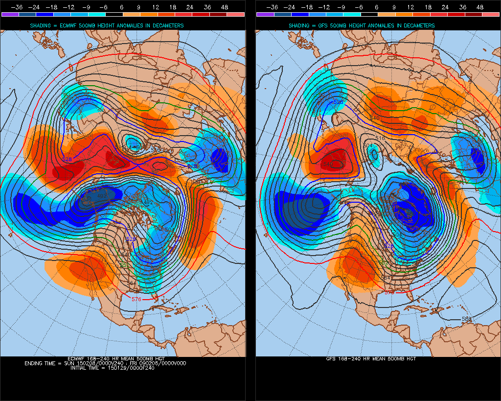
00z ECM/GFS 8-10day H500 comparisons shows Azores ridge building NE towards Scandinavia as trough/lows to the east, bringing the northerly, sinks SE into eastern Europe.


