Synoptic outlook for the rest of January, turning more changeable from tomorrow, with days of milder weather but also days of colder weather as the westerly jet meanders across the UK. Wind & rain at times, with dry and brighter spells too - especially in the colder interludes.

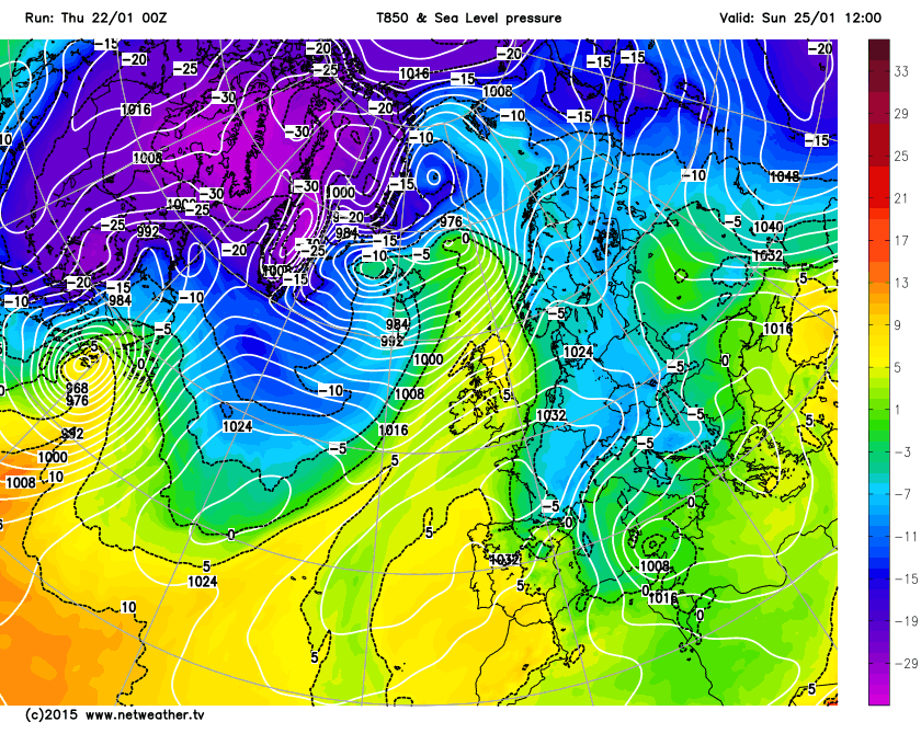
The current cold spell looks to ease through tomorrow, as the current wedge of cold air that moved down across the UK last weekend eases away east tomorrow, to be replaced by somewhat milder conditions from the west for a time. Colder air returns again from the NW across all areas by Saturday, but this will be part of a more changeable and unsettled pattern returning that we’ve seen through much of this winter so far. So from Friday and through next week we will see spells of milder conditions ahead of Atlantic low pressure systems passing east to the north of the UK near Iceland and spells with a colder polar maritime westerly or northwesterlies following behind these systems. The milder spells will see generally cloudy conditions, with spells of wind and rain, the colder spells seeing clearer conditions with showers which will be wintry toward the north.
After Wednesday’s dull and raw day across England and Wales, with some snow in places, Thursday’s looking generally drier and brighter but still on the cold side. The best of the sunshine today across central, northern and eastern England, Scotland and nafter a grey start across many areas. Then we see signs of a change across the NW later on Thursday, as winds strengthen and a band of rain arrives. Then on Friday, isobars tighten and the southwesterly wind strengthens bringing in milder air, while a set of weather fronts moving in from the west will spread cloudier skies and outbreaks of rain southeast, though the SE of the UK staying bright and cold until after dark. A cold front clears the cloud, wet and mild conditions away from all areas Friday night to be replaced by colder and clearer conditions from the north, with wintry showers returning across Scotland.
Then on Saturday, we see a ridge of high pressure build between weather systems, bringing dry and sunny weather across much of the UK, though some wintry showers still across the north of Scotland at first. Then the next Atlantic weather system arrives on Sunday, although the deep low responsible is way to the north, strong southwesterly winds and patchy outbreaks of rain along weather fronts will spread across the many parts. The rain heavy across the north and combine this with temperatures reaching double figures, will lead to rapid snow melt across the north.
Milder and windier conditions arriving Sunday, ahead of deep low near Iceland:
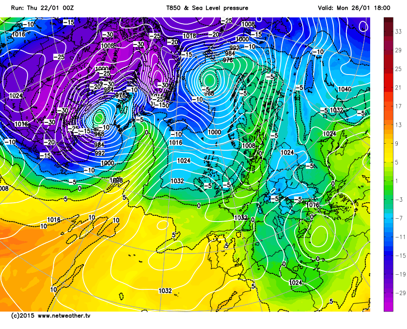
Next week continues with the changeable, unsettled and often windy theme, as a strong Atlantic jet stream buckles and meanders back and forth across the UK, bringing milder air at times and also colder conditions too. On Monday, we see the jet stream dive south across the UK, returning us to colder conditions, with wintry showers across the north. The jet meanders back north a little on Tuesday, with some rain spreading though most areas by late in the day and turning milder with it. Colder again on Wednesday, then another mild tropical maritime sector moves in through Thursday.
Colder conditons return on Monday, as deep low to the north moves away east, then another milder sector to the west ahead of next system arrives for Tuesday:
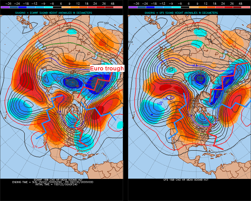
Some divergence later next week, recent and current NWP guidance has generally suggested that the jet will then start to dive south again at the end of next week with the UK back on the cold polar side of the jet, as a deep trough begins to carve out over central and eastern Europe in the last few days of January. Recently and currently, there has been some model support and limited GEFS ensemble support for the UK to stay in the cold polar side of the jet as we enter early February, this is still supported by 00z ECMWF deterministic run this morning up to day 10 and likely after. This ties in to the signal for a generally more amplified long wave upper flow pattern setting up upstream too, with a persisting ridge over western North America and deep trough over eastern N America teleconnecting to the Azores high building slightly north and a deep trough developing over Europe. This would mean we stay in a cold northwesterly pattern for longer into early February ... though this depends on how far east or west the European trough, where the jet is flowing into, sets up – which the models have yet to resolve. The Euro trough too far east and this lets in the Azores ridge from the west and brings a higher chance of milder Tm airmass dominating. Further west, as per 00z EC deterministic, then we keep in the cold, with any amplification north of the Azores ridge over the Atlantic increasing the potential for cold arctic northerly outbreaks too, as showing from some recent NWP operational runs and a few of the NWP ensemble members. Though any northerly outbreaks, bringing potential for much colder conditions and risk of snow, would likely last only a few days, given lack of a signal for high latitude blocking for now.
8-10 day H500 GFS v ECM comparison - more convoluted upper/500mb flow over N Hemisphere, which slows to allow deep troughs and ridges upstream that teleconnect to a prominent Azores ridge and Euro trough allow mean colder NW flow late Jan and perhaps into early Feb.