


Latest synoptic outlook, looking at the the weather 'bomb' arriving across the UK, followed by a chilly spell of weather with snow over northern hills.
A more disturbed pattern than we've been used to in a while is unfolding for the rest of this week, starting with an intense depression moving east between Iceland and Scotland over the next 24-36hrs, the centre between 945 and 950mb passing close to the Faeroe Islands Wednesday morning.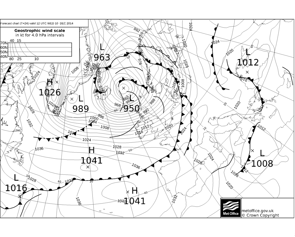
The depression has passed its most intense phase SW of Iceland and will slowly fill over the next 24-36hrs as it moves east, as the jet strong westerly 180mph+ jet streak moves away to the south across the UK. However, it will still be a very deep depression as it passes to the north of the UK and with the Azores high pushing quite far north too, a tight pressure gradient will exist. Not only will there be a risk of severe gales from the Midlands and North Wales north from now until Thursday or storm force winds around western and northern coasts of Scotland – there will also be unusually high waves along Atlantic coasts of Scotland, with wave heights in excess of 15 metres (50ft) possible from now until late tomorrow. To put this into perspective, the average 2 storey house is around 8m high. Already we’ve see waves/surge breaching coastal defences across western Scotland.
We’ve seen strong wind gusts of 60-70mph across northern areas on Tuesday along or near the cold front surging ahead of this deep low and sliding SE across northern Britain this afternoon. Winds will ease slightly before further strengthening overnight and through Wednesday as the pressure gradient tighten across northern UK as the low passes to the north. We could see wind gusts of 80mph+ in exposed parts of northern and western Scotland along with the north coast of N Ireland, 60-70mph widely across Scotland, NW England, N. Ireland and N Wales.
A cold front bringing a band of rain and gales, currently passing down across southern Scotland and EIRE, will clear the south coast of England Wednesday morning followed by an increasingly cold and showery polar maritime flow. These showers have set in this afternoon across Scotland and will spread further south across northern England, N Ireland, north Wales and north Midlands. Showers will fall as snow increasingly to lower levels by the end of the night across Scotland, settling above 150m and perhaps temporarily at lower levels. Further south, snow mainly confined to the hills. Some of the showers maybe accompanied by hail and thunder. These wintry showers continuing on Wednesday across Scotland, Northern Ireland, northern England, north and west Wales, snow settling to lower levels across northern Scotland, but to the south mostly over the hills. Some significant accumulations likely across higher ground. Temperatures on Wednesday struggling to around 4-6C across Scotland, N Ireland and northern England, 7-9C further south. The wind chill making it feel a lot colder though.
The wintry showers continuing through Thursday over the same areas, with snow settling over the hills and to lower levels across northern Scotland. Cloud and rain spreading across England and Wales as a warm front / stratiform cloud spreads in from the Atlantic. A more active wave and associated frontal system pushes in from the Atlantic early Friday, spreading heavier and more persistent rain in from the west across EIRE, N Ireland, England, Wales and southern Scotland. Potential for snow on the northern flank of the rain area of this system though some differences from model guidance to where this may occur. 12z GFS has snow on northern flank across N Ireland/EIRE. North Wales, northern/central England. 00z ECMWF and UKMet were pushing rain a lot further north across Scotland, with only southern Scotland likely to see snow, now the 12 ECMWF has trended further south towards GFS solution. We won't know exactly where the northern extent of the rain meeting the cold draining south will be until nearer the time.
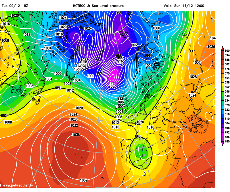
The rain/snow should clear Friday afternoon followed by a brief colder and clearer northerly flow with wintry showers around northern coasts before winds back northwesterly into Saturday. Winds then back westerly then southwesterly into Sunday, bringing in milder air with cloud and rain ahead of another potentially intense depression (below) passing close to Iceland before heading towards Norway, this system is modelled further north this time, so perhaps not such a high impact as Wednesday's 'bomb' - but one that needs monitoring.
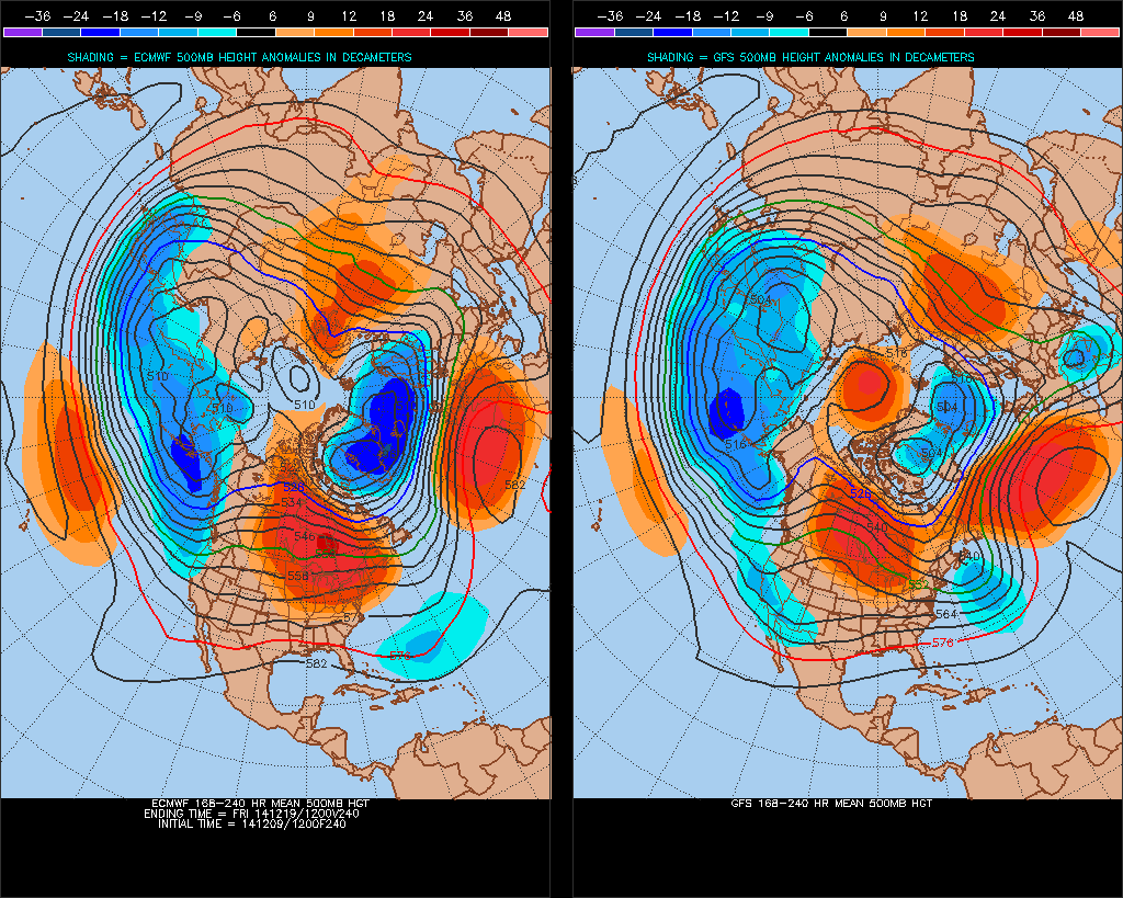
Next week - a cyclonic westerly or northwesterly flow prevailing as further lows track SE from Iceland area towards the North Sea. 12z GFS and ECMWF diverge past mid-week (Weds 17th) - with GFS buckling the flow more to allow a cold NWly flow by Thursday. ECMWF keeps the flow flatter with a milder westerly flow right up to the end of the week.
Beyond - no signs of any big change from the overall pattern likely next week, with low heights and low pressure systems dominating to the north and the Azores high pushing more influence into western Europe, which may settle things down across southern UK.


