


Sunny Leith
-
Posts
1,084 -
Joined
-
Last visited
Content Type
Forums
Blogs
Gallery
Events
Learn About Weather and Meteorology
Community guides
Posts posted by Sunny Leith
-
-
Just back in, and utterly gobsmacked at what its like on the ground down here. True, only a couple of extra cms since this time yesterday and I make it a final 13 cms (FAO @Hawesy) from the same/best level spots I could find yesterday, But the drifting is the story here same as everywhere else. Various spots just across the road where its been scoured into 2-3 feet by the vicious wind. Rural/upland folk must be in ongoing danger of having roads blocked almost as quickly as they've been cleared.
One addition to the landscape here, a primitive unfinished igloo needing some Glaswegian igloo experts to complete it... In the meantime I'm going to name it Edinburgh's Snaw Disgrace to match the Calton Hill monument...

-
 8
8
-
-
4 minutes ago, pdiddy said:
Looking further ahead, some tentative signs for higher heights in Greenland. Northeasterly anyone? Now that we have drained Siberia of cold, seems like the next best outcome...
I'll go with Catch's angle. A slow thaw to avoid flooding even if that means remaining cold/rather cold to get there. After that to be honest I will be gagging for warm sun on my face and mid 50'sF. I want cold in winter where it belongs and dragging it all out into late March/April just isn't my thing any more. Obviously getting old !
-
1
-
-
Ha ! To think my wife questioned why I bought a box of instant-mash at the start of the year, saying that it was destined to become a back of the cupboard discovery in 5 years time. Come the freeze, and today she says she'll be using it to make fish pie. As usual, man the hunter has provided !
PS no idea why I actually bought it, nostalgia I guess !
-
1
-
-
Well, it's dullsville here in Leith. Grey with occasional snizzle. Local hat on, think we can say now that the big streamers/big convection showers are done as the cold uppers recede from west to east and moderate. Edinburgh/Glasgow airports reporting 32/33F so we're getting to more marginal situations at sea-level. Although whether the central belt basks in 34,36,37F the next 2-3 days probably won't make that much difference to existing snow cover. And probably no clear-skied frost to consolidate things overnight so I guess we end up with an imperceptibly slow thaw. Snow will get claggier but thats way better for making huge snowmen than when it was all powder. So I don't see an immediate end to fun for the kids. Bound to end in a slush-fest sometime though and that's when I really will want to see the back of it !
-
4
-
-
12 minutes ago, JoeShmoe said:
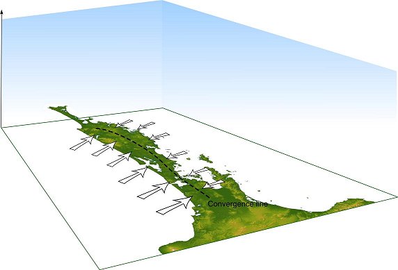
I think its convergence lines ... so basically the sea breezes converge together and cause uplift / shower formation. So this is why you get bands that are miles apart as the air above a band is blowing 'down' into that convergence line and the air below a band is blowing into it, hence why you get the gaps ... can only happen over the sea i think . As to where they form and why and how stable they are i really dont know !
Edit. Looks like that line has gone north again and embra back in firing line of next batch - or maybe thats hopecasting :-)
Cheers for that, I realised I was sagely go along with "convergence lines" as if I knew what I was talking about ! Yeah, looks like the line or streamer or whatever still has something for us
-
2
-
-
Anyone able to educate me on this ? Radar as fascinating as ever. Looks like 4 (arguably 5) streamers going east-west just now. All more or less spaced 25-30 miles apart (approximately). What causes that regularity, or is it more chaotic than that and I'm just seeing a pattern that isn't really there ?
-
1 minute ago, Polar Side said:
I've had to move upstairs as can't see out the living room window for the snow sticking to it.
Robber.
-
6 minutes ago, 101_North said:
Just over an additional 4cm in no time!!
Hey I was happy for you yesterday.
But that was yesterday. CONVERGENCE LINE THIEF !
-
1 minute ago, CatchMyDrift said:
It goes from "ah, I think that's the end of the snow" to "ah, I think it's the end of the world" in 60 seconds.
Even once the worst of the snow showers die back we've still got a cold outlook ahead. The SSW has delivered heartily.
Aye. To be honest though I'd be just as happy if we could somehow flip to an early and warm spring. It's felt like a long winter and a cold March and April would be really dragging things out. Regardless, the models/outlook appear cold for the foreseeable, and most of this snaw could still be hanging about for ages in March for anywhere that has some reasonable elevation.
-
3
-
-
4 minutes ago, JoeShmoe said:
So now had just over an hours solid snowfall and more to come. if the streamer doesnt sink ...
That pair are stealing the best bit of it ! Anyway it was a nice hit. I was getting into a panic seeing a few bare roof-tiles on the tenement opposite and that's covered them up again
-
2
-
-
14 minutes ago, JoeShmoe said:
crazy snaw here now and heading your way very soon it looks like !!
4 minutes ago, 101_North said:WOW! Pelting down here
See if you and @Polar Side steal that big fat long streamer all the way back to Eyemouth me and JoeShmoe will be spewin' !
-
1
-
-
Just now, sn0wman said:
Wow! Heaviest snow yet of this spell here
Today could potentially end up being more severe than yestreday for whoever the convergence line decides to settle on.
Just now, Polar Side said:Hope so, myself and 101 will welcome it with open arms !
Yup think it's sinking your way. First time I've been able to see the Fife Coast in for quite a while, so looks like some kind of clearance here "this side of the convergence". I could be talking sh1te though !
-
5 minutes ago, 101_North said:
Send it this way! Too sunny for my liking just now
Noticed that the local home-met stations have dropped a couple of degrees again in the past hour, although the fact that it's snowing again is probably explanation enough.
-
1
-
-
4 minutes ago, sn0wman said:
Convergence line sitting right over Edinburgh now
Looks like it's moving south pretty quickly though...
Also maybe got a slightly south of east to a slighly north of west tilt to it though. Certainly it's doing the business here just now and would like it stay for 30 minutes at least !!
-
2
-
-
3 minutes ago, 101_North said:
Still tracking just a tad too far north of here. We're catching the edges and although they are heavy they aren't lasting more than a few minutes.
Possibly the line is sinking towards you as well. Although JoeShmoe and I would be perfectly happy for it to stall right here for an hour or two !
Edit: talcum powder whiteout is back.
-
3
-
-
10 minutes ago, CatchMyDrift said:
Look at this FAX chart and then look at the radar animation. You can see the convergence lines as streamers on the radar, let the animation play a few times. They seem to be sinking south and tilting more onto a straight W-E axis at the same time. Any one else see different? Radar can be so hard to see properly sometimes.
"Probably" ! The line that was aiming at East Neuk of Fife at about 12:40 on the radar, now seems to be aiming to North Berwick at 14:25. Probably thats why we've now started seeing a bigger concentration of them getting through to Edinburgh as @JoeShmoe suggested.
-
Can't say with certainty but think we're past peak snaw here for most of Edinburgh, well Leith anyway. Fewer blobs and fewer hits, and the ones we do get are more fleeting and lighter. Subtle change in flow maybe (although hard to tell from radar replay) and a lot more high-cloud today, wonder if that's limiting convection a bit. Aware that uppers are moderating a bit too. That said, looks like lots of folk are still in the firing line for mair heavy snaw, good luck !
-
2
-
-
- Popular Post
Couple more from earlier. Wind-scoured Calton Hill 5 minutes up the road from me, and The Mound.
-
12
-
11cms here in Hillside Gardens my nearest flat space. A close enough miss by @Hawesyand no complaints from Leith, we always have to deal with being a fairly coastal location. Paolozzi foot in the snaw here.
-
7
-
-
1 minute ago, Glaswegianblizzard said:
Make sure you take supplies mate. The news here intereviewed a guy stuck on the motorway who only had two mars bars - take more than that,
Would hate to be stuck in one of these situations and I'm not "blaming" everyone who got stuck. But seeing on social media that some folk were somehow expecting to be checked in their vehicles by emergency services. How is that meant to work ? Hundreds of cars and lorries and only so many police and local authority workers who can deal with the situation. Crazy expectations folk have in these situations.
-
3
-
-
Bigger gaps inbetween but another talcum powder hit here. Once these things get going it's hard to separate whats falling from the sky, from the spindrift being kicked up from roofs and streets.
-
3
-
-
Huge amounts have piled up here overnight and just had another heavy shower pass through. No obvious let-up on the radar. Gap-whiteout-gap-whiteout and repeat.
-
5
-
-
2 minutes ago, 101_North said:
Just relentless heavy showers this evening. A day to remember for certain! Tanking down again
Malt must be half empty by now
-
1
-
-
2 minutes ago, JoeShmoe said:
Lol, absolute blizzard here now , mental stuff ...
This ones a cracker.
-
2
-


Scotland/Alba Regional Weather Discussion - 16/01/2018 Onwards
in Regional
Posted · Edited by LeithRayOfSunshine
Credit to them for that. Wee rant though. Princes St Gardens (East and West) are both closed to the public despite being one of the most scenic spots for a winter snaw walk in the the middle of Town. They were perpetually open in 2010 but seems now we have "Health and safety gone mad". But it's council logic today that takes the biscuit. They've completely snow-cleared the public walkways in the (closed) gardens, whilst leaving adjacent Princes Street pavements a friction-free ice and slush-fest inviting multiple OAP and tourist visits to A&E. Go figure!