JamesL
-
Posts
327 -
Joined
-
Last visited
Content Type
Forums
Blogs
Gallery
Events
Learn About Weather and Meteorology
Community guides
Posts posted by JamesL
-
-
Elongated low on the ECM which will undoubtedly move further south as we progress through this week of model watching. Right now from an IMBY perspective the valleys in S Wales would get pounded
-
 1
1
-
-
4th morning on the trot here with falling settling snow at a modest 150m ASL in the Cynon Valley
Last winter 21/22 we saw a big fat ZERO of snow days
-
 4
4
-
-
-
-
Well as expected a great fall overnight. Best since TBFTE in 2018 here. We’ve been in the perfect place here near Aberdare under the brighter returns most of the night. I’m guessing 5-7 cms but I’ll get out with a tape once out of bed.
looks like heavier stuff arriving this afternoon too
A great last hurrah by winter 2022/23
3 minutes ago, DeepSnow said:Great to see Barry enjoying this too. Must be a first since 2018?
-
 1
1
-
-
Well I’m certainly liking the 12z ECM’s take on tomorrow for the Valleys
I’m around 150m asl here so I’m expecting a decent covering. Maybe a dusting over night tonight followed by 5-10cms by tomorrow night
Then I’m quite happy for spring to come
-
 2
2
-
-
17 minutes ago, thetipster said:
Forecast model: ECMWF 9km
Provider: ECMWE 06z
Next update expected at: 19:39, in 5h 55m 37s
Update interval: 6-7 hrs
Reference time: 2023-03-07T06:00:00ZThat’s a lot of falling snow for SE Wales over around 24 hours. Heads of the valley looks a prime sweet spot
-
 1
1
-
-
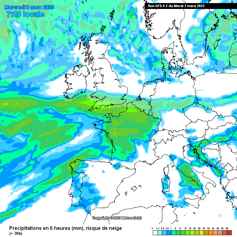
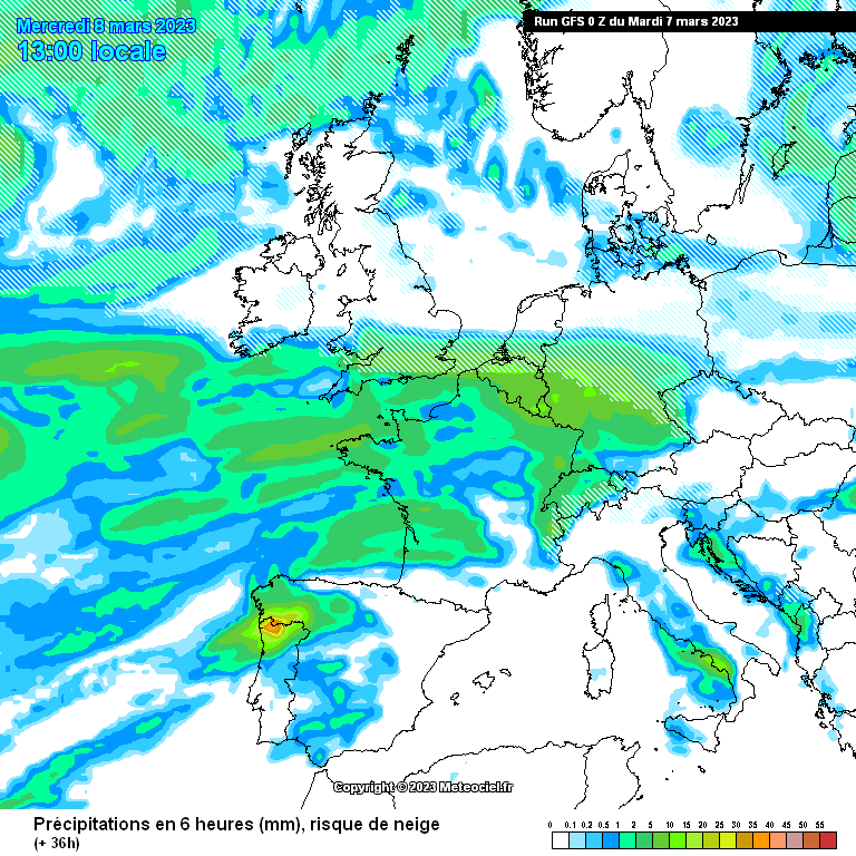
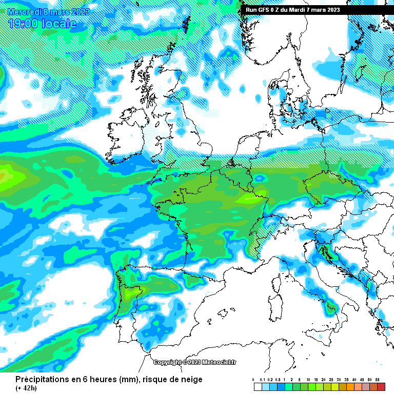
Looking at the 0z GFS it gives SE Wales around 12 plus hours of snowfall tomorrow from 5am through until evening. I think with elevation of 150m we could see a few cms sticking
-
 1
1
-
 1
1
-
-
42 minutes ago, MJB said:
I’m really liking these charts for the SE Wales valleys for tomorrow. I think areas above 150m could well have 12 hours of snow according to the 0Z GFS
Had a dusting on the hills around me here today and snow here but no settling.
It will Potentially be our last snow for this season tomorrow unless the chopping and changing continues into the weekend and we get another injection of cold from the N/NW as the shortwaves exit
-
 2
2
-
-
Just now, Mike Poole said:
In a way, I am comfortable with a slightly more northerly tracking low at this point, if we are counting on it for snow in many regions. Experience would suggest these things tend to correct south as we approach T0. When was that one that ended up shifting so far south it pasted Guernsey?
Was it 2013?
-
 1
1
-
 1
1
-
-
Looks frigid here in the valleys next week
 I think many in the south will be very disappointed. Not even a particularly cold spell for early March. Temps haven’t been far off that this week here with more frosts. It’s all very confusing with all this talk of cold, snow and record minima. I think it’s going to be a NE England and Scotland spell with the rest getting the left over dross
-
 1
1
-
-
Looks like the ECM sniffed out the more northerly approach of the low last eve. And now sadly the UKMO has also sniffed it out. As always in these cases betting against the 2 Euros over the American model is a dangerous move
cold for 2-3 days before a messy breakdown from the SW is pretty much what we will have by the looks of it
let’s move on and look for spring. Personally it was all to good 24-48 hours ago
One could argue that things may well correct south but it’s a worrying trend this morning
I think by the 00’s tonight we will know our fate
-
 1
1
-
 1
1
-
 1
1
-
-
1 minute ago, alexisj9 said:
With that warm core shows it is a polar low. Snow would be amazing, and proper blizzard conditions in the south. It won't stay like that. I don't think the south has seen a real blizzard in my life time. A lot of people would get onto trouble with that. Would be interesting to see, if sensible enough to listen to warnings and stay in doors. If this or something like it does materialise, I hope people do take note of the red warnings, and hope all homeless are looked after with shelter for the whole cold spell. Also heating wise those struggling now, are looked after properly so they can heat their homes.
Errrm we had snow drifts up the the roofs and cars buried in the St David’s day blizzard in 2018. So unless you’re younger than 5

-
Think this will be the last of the snow here today. The area of instability is moving away and the shower activity vanishing with it slowly but surely behind it.
Fun whilst it lasted and nice to see the forecast spot on for here near Aberdare
A perfect time to get out into the hills and grab some pics esp tomorrow with the sun out
Zoomed in and out. We hit this one perfectly
-
The chunk hit

-
 3
3
-
-
-
8 minutes ago, Jayfromcardiff said:
I agree, we had 4-5cm of snow last Saturday night from a similar setup.
Yeah we missed it here by just a couple of miles. Ponty and south towards M4 got an inch or two and the hills around got more. I drive home from Bristol and we had a dusting in the city centre
-
 1
1
-
-
Just now, blackrose73 said:
The Bristol Channel can be a real blessing in these situations.
Yes and ironically in a WSW wind lol
-
 2
2
-
-
2 minutes ago, Jayfromcardiff said:
Looks really heavy mate.
This seems just to be the front edge. Really depends on how the mountains to the west sap the energy. If not then we could end up with 3-5cm looking at the radar returns
-
 1
1
-
-
-
Just now, Jayfromcardiff said:
Fingers crossed you get some snow tonight.
Let’s see lol would be nice to have a dusting
-
 1
1
-
-
3 minutes ago, Jayfromcardiff said:
Any snow yet?
No Maerdy mountain is preventing any precip here. It’s dying in the Rhondda
-
 1
1
-
-
Showers definitely pepping up now heading up the Neath Valley. Hoping Aberdare gets a few showers. We missed last Saturdays snow by about 2 miles lol
-
 1
1
-
-
6 minutes ago, AlexThe Great said:
Anybody in that blob around Kidwelly? What's falling ?
I’m sure inland they will be falling as snow esp above 100/150m
-
 1
1
-


Model Output Discussion - Spring Has Sprung
in Forecast Model Discussion
Posted
So with low pressures historically moving south over time, what are people’s thoughts here?
A slightly different scenario to last time as cold arctic air isn’t entrenched over the uk as we saw the snow slip into France etc
Any chance here or am I straw clutching?