


Highland Snow
-
Posts
688 -
Joined
-
Last visited
Content Type
Forums
Blogs
Gallery
Events
Learn About Weather and Meteorology
Community guides
Posts posted by Highland Snow
-
-
Beautiful Aurora over The Giant's Causeway, Co. Antrim:

-
 6
6
-
-
I refuse to look at any more aurora pictures as I'm in a strop about not seeing it yet again.
Anyway, its -3.4C here this morning currently and frosty again. Two frosty mornings in a row must be approaching a record for this winter.
One more Ravelin, The Giant's Causeway, Co Antrim, N. Ireland.
-
9
-
-
Cairngorm weather station before and after!
-
4
-
-
It so quiet on the weather front today. Went for a walk without the winter jacket and was glad I did.
Since it is so quiet I thought I'd bring some music/geology/ weather to this Sunday evening.
This song by 'Loch Lomond' (they hail from NW USA) is called 'Made of Ink' about Mt. St. Helen erupting in 1980. Ritchie woke up the morning after and thought it had snowed overnight. No. It was 6 inches of ash.
Interestingly the event in 1980 at Mt. St. Helens literally blew the uniformitarian Geologic interpretation to smithereens:
http://creation.com/i-got-excited-at-mount-st-helens
And simultaneously demolished the holy grail of the radioactive dating methods:
-
1
-
-
Pause for thought:
-
3
-
-
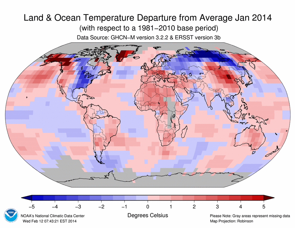
Globally, January 2014 had highest temps since 2007
January 2014 also marked the 38th consecutive January and 347th consecutive month (almost 29 years) with a global temperature above the 20th century average.
According to NOAA scientists, the globally-averaged temperature over land and ocean surfaces for January 2014 was the highest since 2007 and the fourth highest for January since reliable record keeping began in 1880. January 2014 also marked the 38th consecutive January and 347th consecutive month (almost 29 years) with a global temperature above the 20th century average. The last below-average January global temperature was January 1976 and the last below-average global temperature for any month was February 1985.
Most areas of the world experienced warmer-than-average monthly temperatures, with the most notable warmth across Alaska, western Canada, southern Greenland, south-central Russia, Mongolia, and northern China. Parts of southeastern Brazil and central and southern Africa experienced record warmth, contributing to the warmest January Southern Hemisphere land temperature departure on record at 2.03°F (1.13°C) above the 20th century average. Temperature departures were below the long-term average across the eastern half of the contiguous U.S, Mexico, and much of Russia.
However, no regions of the globe were record cold.
Read temperature highlights of January 2014 from NOAA
January 2014 blended land and sea surface temperature anomalies in degrees Celsius
-
1
-
-
Image of polar vortex at its peak, January 2014
NASA image shows the polar vortex as it plunged into the United States, on its peak day of January 6, 2014.
Image credit: NASA
Blistering cold air from the Arctic plunged southward this winter, breaking U.S. temperature records. On January 6, 2014, alone, approximately 50 daily record low temperatures were set, from Colorado to Alabama to New York, according to the National Weather Service. In some places temperatures were 40 degrees Fahrenheit colder than average.
A pattern of winter winds that spin high above the Arctic, known as the polar vortex, typically blow in a fairly tight circular formation. But in late December 2013 and early January 2014, the winds loosened and frigid Arctic air spilled farther south than usual, deep into the continental United States.
This image is made possible by NASA’s Atmospheric Infrared Sounder, AIRS, in conjunction with the Advanced Microwave Sounding Unit, AMSU. The two work in tandem to sense emitted infrared and microwave radiation from the Earth to provide a three-dimensional look at Earth’s weather and climate. The two instruments make simultaneous observations all the way down to the Earth’s surface, even in the presence of heavy clouds.
click here to go to NASA’s page on The Big Chill.
-
5
-
-
Can confirm the passing of the cold front with heavy squally rain and temperature now 8.8C (-1.9C/hour) - textbook!
-
Currently 10.8C with 100% cloud cover but an approaching cold front will lower that temperature and clear the sky somewhat.
-
He had his Phil!
-
1
-
-
In Edinburgh this morning and although 8C by 13:00 the wind of the Forth would skin a rabbit.
-
1
-
-
All the snow (slush!) gone and no wonder with a maximum of 8.3C today. Glorious sunshine this afternoon.
-
Road conditions on A85 between Crieff and Methen atrocious with horizontal large snowflakes making forward visibility very poor. Less severe here but still a few cms of slush! Currently 1.0C/+0.3C.
-
Five hours and no posts oh dear. Maximum today was 5.6C with 3mm of rain/sleet.
-
5
-
-
Sleet showers here this morning at 2.7C/+1.7C.
-
Radio 2 Traffic Reports - avoid Tyndrum as vehicles stuck in the snow, no access to Spittal of Glenshee which means there will be many stuck up there going on earlier pictures of overflowing car parks.
-
Altnafeadh, Rest and Be Thankful, Tyndrum and Glen Ogle all have heavy lying snow
-
2
-
-
Rain just starting at 3.1C/+1.3C.
-
1
-
-
Currently +0.3C/-0.2C (proof-read) with a few flakes of new snow since 03.00 and everywhere is a skating-rink.
-
1
-
-
Now 03.00 and most of the earlier snow has melted with +1.2C/+9.4C Temperature values.
Oh dear Catch, you should take up proof-reading - it was three in the morning and with no lights on (bit like you yesterday morning probably!!)
Correction should read +1.2C/0.4C!
-
1
-
-
Now 03.00 and most of the earlier snow has melted with +1.2C/+9.4C Temperature values.
-
Now 0.8C/-0.5C bring on the showers.
-
1
-
-
Temperature has really plummetted after those showers. Now +1.2/-0.2C (-1.9C/hour).
-
More activity on here in 20 minutes than in the last week - the power of snow!
-
6
-


Scotland Regional Weather Discussion 27/01/14
in Regional
Posted
Spring is on its way next week. Mrs HS was pruning trees today and I can confirm the sap is rising!