


johnholmes
-
Posts
22,964 -
Joined
-
Last visited
-
Days Won
84
Content Type
Forums
Blogs
Gallery
Events
Learn About Weather and Meteorology
Community guides
Posts posted by johnholmes
-
-
Dry and mostly cloudy; current low is 8.3 C, my average daily max for February!
-
Well a long time since I created a post using the usual models ( 2 Feb the last times)
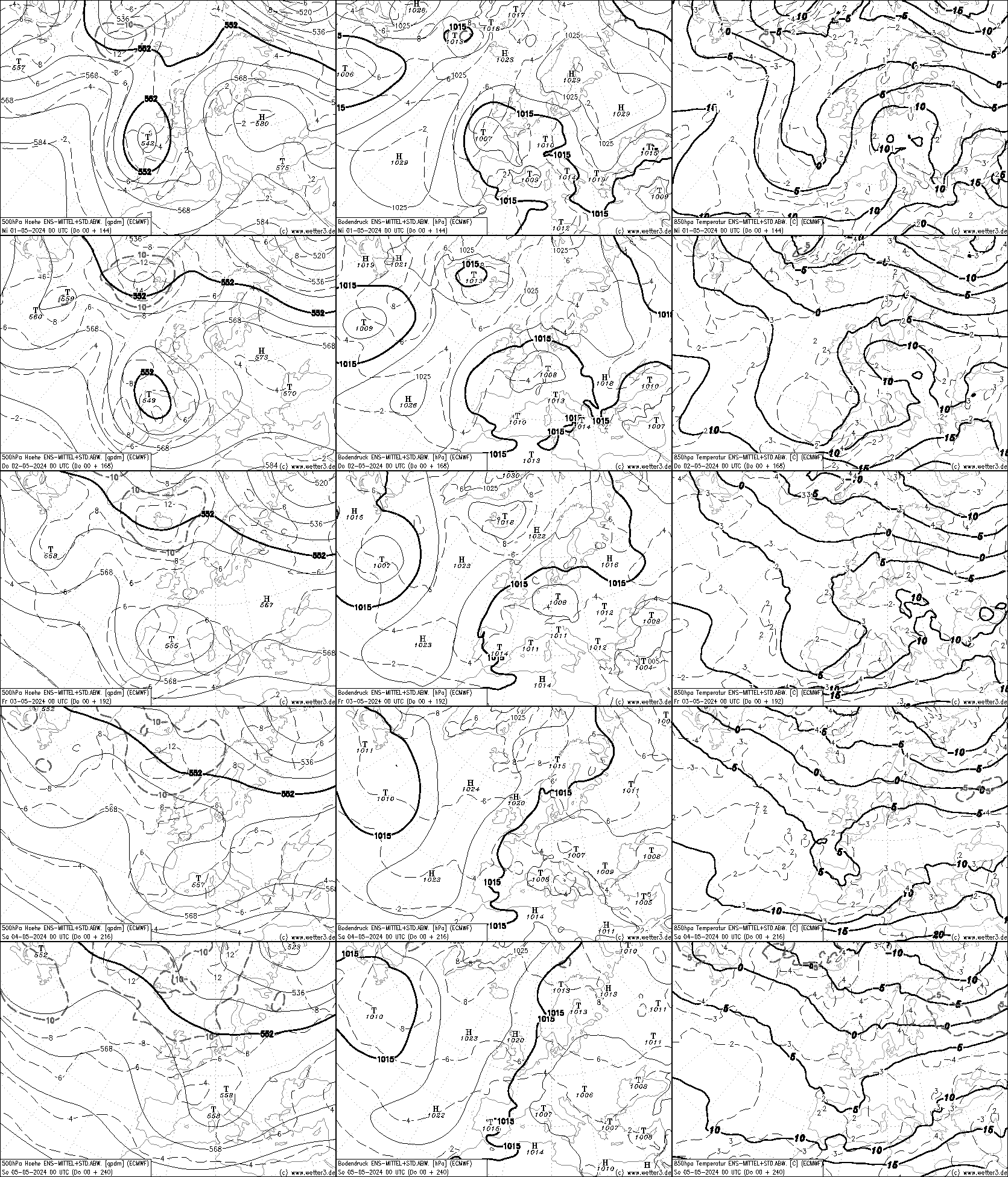
In brief for approximately 23-27 February all 3 are on the same page. They show a marked upper trough over the UK edging slowly east and warming out slightly. On the surface ECMWF shows a deep low just south of Iceland on day 1 (27Feb), NOAA shows a marked 500 mb trough over the UK from a flabby sort of main trough NE Canada/NW Greenland by 26 February. UK Met 20-22 February shows a similar pattern with a marked upper trough and surface feature over the UK.
NOAA has contours on its 6-10 over the UK from about 520-534 DM north to south over the UK. So cold by the average expected for late February. ECMWF shows a quite strong northerly pulling in the cold air, surface and at 500 mb. UK Met by its last date (22nd) shows a strong NNW’ly over the near Atlantic with a rather flabby low over the Northern Isles and a high west of the NNW’ly flow.
Further ahead ECMWF indicates an upper ridge moving east into the SW along with a surface high a bit west of 20W at the same latitude as northern Spain.
NOAA with its 8-14 day chart has a +ve height anomaly of 150 DM or so in about the same place as the ECMWF surface high.
These charts would suggest that by the 27-28 February the cold air supply is being cut off. Probably by next Saturday ‘deepish’ cold air will be covering most parts, say -4 to -5 C at 850mb. I would think these conditions lasting until about month end?
Just my take on the outlook!
I'll try and post the charts I used to arrive at this
 Climate Prediction Center - 6-10 Day 500mb Outlook
WWW.CPC.NCEP.NOAA.GOV
Climate Prediction Center - 6-10 Day 500mb Outlook
WWW.CPC.NCEP.NOAA.GOV
Original post: https://community.netweather.tv/topic/99814-model-output-discussion-22nd-jan-2024-onwards/?do=findComment&comment=5038707-
 1
1
-
-
- Popular Post
- Popular Post
Well a long time since I created a post using the usual models ( 2 Feb the last times)
In brief for approximately 23-27 February all 3 are on the same page. They show a marked upper trough over the UK edging slowly east and warming out slightly. On the surface ECMWF shows a deep low just south of Iceland on day 1 (27Feb), NOAA shows a marked 500 mb trough over the UK from a flabby sort of main trough NE Canada/NW Greenland by 26 February. UK Met 20-22 February shows a similar pattern with a marked upper trough and surface feature over the UK.
NOAA has contours on its 6-10 over the UK from about 520-534 DM north to south over the UK. So cold by the average expected for late February. ECMWF shows a quite strong northerly pulling in the cold air, surface and at 500 mb. UK Met by its last date (22nd) shows a strong NNW’ly over the near Atlantic with a rather flabby low over the Northern Isles and a high west of the NNW’ly flow.
Further ahead ECMWF indicates an upper ridge moving east into the SW along with a surface high a bit west of 20W at the same latitude as northern Spain.
NOAA with its 8-14 day chart has a +ve height anomaly of 150 DM or so in about the same place as the ECMWF surface high.
These charts would suggest that by the 27-28 February the cold air supply is being cut off. Probably by next Saturday ‘deepish’ cold air will be covering most parts, say -4 to -5 C at 850mb. I would think these conditions lasting until about month end?
Just my take on the outlook!
I'll try and post the charts I used to arrive at this
Climate Prediction Center - 6-10 Day 500mb Outlook
WWW.CPC.NCEP.NOAA.GOV
-
18
-
 1
1
-
 4
4
-
Dry and mostly cloudy, a low of 7.1 C
-
Cloudy, dry after slight rain (1.0mm) overnight, very mild on 12.2 C now, current low is 11.8 C
-
Dry and mostly cloudy after slight rain overnight; just 1.0 mm; lowest temperature was 7.5 C, now up to 10.2 CDry with variable mainly small amounts of cloud, a low of 2.1 C now on 3.1 C
-
-
2
-
-
Sunday starts overcast with rain at times, 3.4 mm since midnight and rain last evening; the lowest temperature so far is 6.9 C
-
Dry with a lot cloud, a low of 4.1 C
-
-
Overcast, dry now after 6.8 mm of rain since midnight, some could be melting snow, ppn yesterday was 18.8 mm along with a max depth of 2 cm of snow, overnight low was 4.2 C its now on 6. 8 C. Nil snow cover
-
- Popular Post
- Popular Post
Met4Cast What on earth is a QTR please?
-
7
-
2
-
1
-
Well, bit of a surprise for sunny donny, 2 cm on my estate with about 2 hours of snow, often moderate in intensity, temperature is finally starting to rise, now 0.7 C having been over 3C before winter arrived.
-
Bit more info for Matty.
The web site will not allow copies but the 1220 on roads spoke of the A6 being closed at Toply Pike, Taddington, this is on the long pull up from Bakewell, other roads are said to be badly affected in the area. Not your concern but A53, A 54, A 537 are closed, they are roads out of and west of Buxton.
Good luck
-
1
-
-
this from Buxton weather, they do full road conditions also
Buxton Weather – Live Weather in Buxton Derbyshire, UK
WWW.BUXTONWEATHER.CO.UK
Buxton Weather – Live Weather in Buxton Derbyshire, UK -
Well something of a surprise here, almost 2 cm of lying snow with complete cover, still slight snow, temperature went up to 3.4 C for a time it's now on 0.6 C, been there about 2 hours. I expect this winter wonderland will be gone this evening, certainly by tomorrow morning.
-
1
-
-
If you want to see snow and like me just have rain this link is a good one for snow, the Winking Man already has blowing snow
Peak District Webcams
WWW.JAMESGPHOTOGRAPHY.CO.UK
A collection of Peak District webcams highlighting current weather and road conditions. Useful for planning photography trips in the Peak District.-
1
-
-
Looks overcast, dry at the moment but radar shows ppn band not far away. Assume it will be rain or sleet here, temperature and TD both well above zero, temperature is 2.5 C and edging up with Td=2. Lowest overnight T=-0.2 C
-
Dry with some cloud, patchy ground frost with the low currently on 0.8 C, still drifting down.
-
Dry and cloudy, with highest gust showing as 23 mph, very mild, current low is 11.7 C
-
mostly cloudy, dry red sunrise, low of 10.1 C, so pretty mild again
-
Cloudy and dry but the radar seems to suggest a short spell of light rain is on its way? Mild with a low of 8.4C, currently on 10.7 C
-
Dry, mostly cloudy, the breeze started after 0800, gusts to 23 mph, a very mild night, the low was 12.1 C; this would be average in late August/early September or late June/early July!
-
Sorry I don't usually repeat my posts but I missed a part off, quite significant so here it is
Not a full post but just showing the latest NOAA 6-14 day charts. Both have a gneral rather cold westerly 500 MB pattern. Not yet showing any signal for deep cold from a northerly point.
The contour over southern England on the 6-10 day is 534 DM which is quite cold so even lower further north. Any ppn in the north would likely be snow and over most hills further south possibly lower at times depending on the actual synoptic pattern.
Add there is a -ve height anomaly over the UK. In spite of the broad westerly at 500 mb this may be a signal for a surface feature to be over/east of the UK. Perhaps picking up on my highlighted original post. Maybe the ECMWF output may show this, I'll go have a look.
Original post: https://community.netweather.tv/topic/99814-model-output-discussion-22nd-jan-2024-onwards/?do=findComment&comment=5027994-
1
-


Daily weather observations - February 19th to February 25th
in Spring Weather Discussion
Posted
Dry and mostly cloudy; current low is 6.7 C