


johnholmes
-
Posts
22,965 -
Joined
-
Last visited
-
Days Won
84
Content Type
Forums
Blogs
Gallery
Events
Learn About Weather and Meteorology
Community guides
Posts posted by johnholmes
-
-
Dry and mostly cloudy after very slight rain around 0300; (0.2 mm); a low of 4.8 C
-
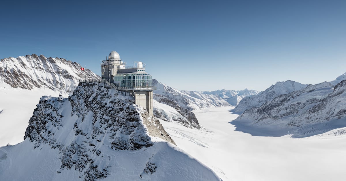
Pretty similar in the Swiss resorts, if the Jungfrau region is typical. Plenty of snow about about 5500ft and surprisingly the runs into the village seemed to stay open. The area shut due to strong winds much of Easter, open now but clothed in cloud.
 Slope data | jungfrau.ch
WWW.JUNGFRAU.CH
Slope data | jungfrau.ch
WWW.JUNGFRAU.CH-
 1
1
-
-
A cloudy start but dry after 1.4 mm of rain since midnight; radar shows this edging away north with another band edging north for later this morning; a low of 7.2 C
-
The dreaded N Sea low cloud starting to move in from the SE
-
Dry with variable cloud, cold with a current low of 1.7 C, no sign of any ground frost
-
- Popular Post
- Popular Post
The 6-10 day 500 mb anomaly chart from NOAA shows a fairly marked Confluent ridge leading into a Diffluent trough off the coast of n America. This can lead to the development of a surface low, possibly rapid deepening. So at some stage in this time scale we could expect a fairly deep surface low to form in that area. The flow is then shown as SW'ly fairly strong at 500 mb. So a rather unsettled outlook in the 6-10 day period seems quite likely
-
7
-
 2
2
-
 3
3
-
Dry and sunny start, a rather cold night with a low of 2.7 C ;now up to 5.6 C
-
Dry and bright with sunny spells; a low of 4.2 C, now on 5.8 C
-
Cloudy with slight rain; 1.8 mm since midnight, rather breezy max of 23 mph overnight, a low of 4.8 C in the early hours now up to 6.9 C
-
Dry and mostly cloudy now after rain overnight; 4.6 mm; the current low is 5.6 C
-
Dry and cloudy, mainly upper cloud, a low of 4.1 C now up to 5.1 C
-
Cloudy but dry but rain showing on radar not far away; a low of 2.8 C now up to 5.2 C
-
A sunny dry start with a low of 5.6 C
-
Dry so far with variable cloud giving sunshine at times; lowest temperature of 4.6 C; radar suggests showers upwind of here. Derbyshire web cams have no snow showing.
-
Dry and mostly cloudy with a current low of 8.6 C
-
Dry and mainly cloudy, temperature is on 6.9 C but has been as low as 4.4 C
-
Cloudy, dry at the moment after 1.6 mm of rain overnight; mild with the current low on 9.8 C
-
So where in Hampshire do you live. I'm sure the weather stats for Bournemouth are nothing like as bad as your post suggests?
-
1
-
-
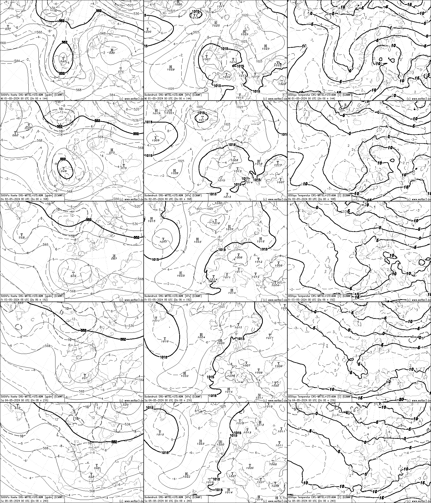
Too far to be sure what Easter will bring but the ECMWF is a fairly good indicator of both upper air and surface along with 850 temperatures. It only goes out to Maundy Thursday but not a bad idea to follow each subsequent update from now
And of course the 500 mb NOAA Anomaly charts the 6-10 out to the same day and the 8-14 over the Easter weekend. This just for an idea of where the main upper air features look like being.
It does, at the moment look like an upper trough will be close to the UK with the 500 flow coming from just north of west.
Climate Prediction Center - 8-14 Day 500mb Outlook
WWW.CPC.NCEP.NOAA.GOVTime will tell, as always, the accuracy of the above charts
-
5
-
3
-
1
-
-
A Dry bright and mild start; low of 10.2 C
-
A dry sunny start with a low of 6.2 C
-
A wet start to Sunday morning; 2.0 mm since midnight, more to come looking at the radar, a low of 9.0 C
-
Dry with patchy cloud and sunshine; some signs of patchy ground frost; a low of 1.2 C
-
Cloudy,dry now after very slt ppn earlier, mild with a low of 10.6 C so far


Daily weather observations - April 1st to April 7th
in Spring Weather Discussion
Posted
Cloudy but dry now, just 0.8 mm since midnight; a low of 8.6 C, even milder now on 10.2 C