


Jeremy Shockey
-
Posts
830 -
Joined
-
Last visited
Content Type
Forums
Blogs
Gallery
Events
Learn About Weather and Meteorology
Community guides
Posts posted by Jeremy Shockey
-
-

For some reason we often seem to get a day of transient snow on the North York Moors around 21st March ........and i wouldn't be at all surprised if it happens again this year !
-
 1
1
-
-
- Popular Post
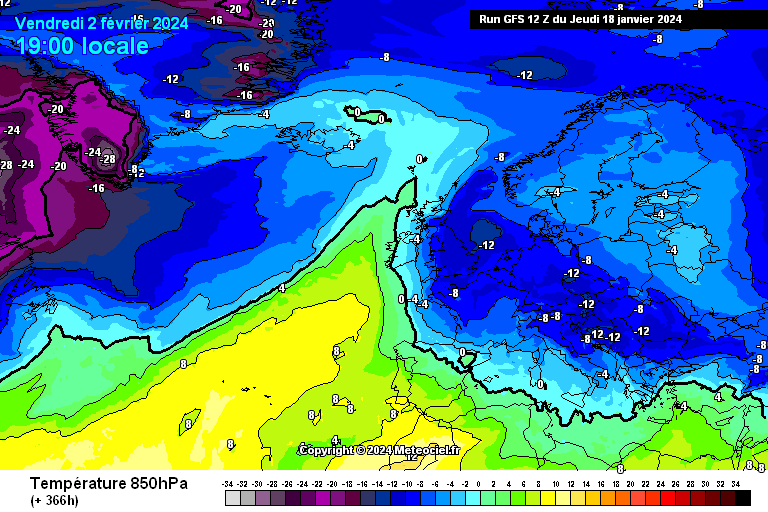
GFS 12z Op 850's for 2nd Feb
Worth keeping an eye on without getting too excited for another 7 days or so
-
11
-
Some good heavy snow showers all the way down to the Humber and surprisingly far inland.
Got a nice dusting in North Newbald-
1
-
-
Scarborough about to get pasted in snow.
-6 here too
-
4
-
-
Maybe a dusting from the back edge as the favourable dew points return after midnight .......but there isn't much precipitation left by then
-
1
-
-
12 minutes ago, Aiden2012 said:
And that’s it it’s going the sun is coming out
 can’t complain I suppose
maybe more for Pock this evening Aiden
-
1
-
-
light snow in East Yorkshire and a slight covering
-
2
-
-
A bit of snow on the coast road near Filey this morning at 10 a.m.
-
1
-
-
11 minutes ago, Scott Ingham said:
Tentative signs on the eps of scandi euro ridge which should in my view push into scandi when we get the movement into high amplitude western pacific phases.
Very encouraging!
yes indeed Scott and would very much tie into the wording of the MetO 28th Jan - 11th Feb long range forecast where they suggest an increased likelihood of high pressure forming and winds from the north or east leading to an increased chance compared to normal of cold spells.
-
7
-
-
- Popular Post
- Popular Post
ECM 12z ensembles . Op near the top. Mean very good indeed ( in the crucial period 14th to 16th )
-
10
-
ECM 12z mean 16th Jan .......is excellent
-
5
-
-
WRF 6z ........bit of Wintry precipitation for the North York moors perhaps overnight ?
-
1
-
 1
1
-
-
ICON 12z ..........id snap your hand off for this 1 week today.
-
3
-
-
GFS 12z for 27th
slider potential for the North of the UK i would have thought ?
-
1
-
-
Short ensembles GFS 12z
Such is the volatility of output at the moment. 18z will probably hold back the low and be much less progressive ( as it did on the 6z run ) and we could have a festive cold pub run with a Northerly. 12z Op at top of ensembles by the looks of things
-
1
-
-
Would not be at all surprised if the GFS 12z tuned out to be a mild outlier for the period 23-26 Dec. Then the 18z goes back to being a cold festive run !
-
2
-
-
-
-
GFS 0z 850's
A huge amount of scatter after 19th Dec with all options still on the table for Christmas Eve and Christmas Day ( including a potent Northerly and warm Southwesterlies ) It would only need the high to form a touch further North and West for a cold festive blast.
Its only 10th Dec. Anything can happen.
-
5
-
 2
2
-
-
GEM 0z for 18th Dec
I'm quite liking the look of the GEM 0z @ 216hrs. If the high was orientated just a little bit more North West we would really be in the game for Wintry blast from the North / North East
-
GFS 0z for Christmas Eve
Well this would be fun if it came off !
-
5
-
-
Sleety rain at low levels in Newbald. Snow on top towards High Hunsley
-
just North East of Driffield this morning at 0800 hrs
-
4
-
-
Thanks Sorepaw ......will be up near Pickering tomorrow morning so might take a detour !
-
1
-


 WRF 6z ........bit of Wintry precipitation for the North York moors perhaps overnight ?

.jpeg.1442fc63bcd6427a093f128135c999b5.jpeg)


.jpeg.43d7ffa71aabe92d3d7065fe42987457.jpeg)

 GEM 0z for 18th Dec


Yorkshire and E England regional discussion - Dec 2023 onwards
in Yorkshire & E.England Weather Discussion
Posted