
- Popular Post


Coopsy
-
Posts
3,082 -
Joined
-
Last visited
Content Type
Forums
Blogs
Gallery
Events
Learn About Weather and Meteorology
Community guides
Posts posted by Coopsy
-
-
Currently one of the coldest periods I've known along with dec 2008 I think it was(minus 42)
Currently minus 41. Wind chills down to minus 50. Even businesses are closing down for the day. Not sure I remember that happening before.

I fancied a Friday fry up too. Oh well.
-
 1
1
-
-
35 minutes ago, cheeky_monkey said:
even so a damp 0c ..doesn't not equate to a dry -40c ..not even close
Totally agree. I used to not really mind the cold til it hit about minus 20. Now its probably minus 15 that gets me.
But minus 40 is just painful. Dry air or not. I can physically feel the body slow down, stiffen and just hurt.
It's not forecast to get any warmer than minus 10ish all next week. Mind you after this week it'll feel positively tropical.
-
 1
1
-
-
Currently minus 30 with wind chill minus 40 and light snow.
A severe cold warning out for most of southern Alberta and almost every province and terrority in Canada has a weather warning in place.
An Arctic intrusion forecast for most of Western Canada and large parts of the US.
Temps forecast to get to minus 40 with wind chills of minus 50 in southern Alberta. Colder ooop North.
Warmest spot in the whole of Alberta - minus 24.6oC. Balmy.
Warm wet and windy in the east coast maritime region.
Cold predicted to moderate but continue.
Miserable

-
-
If anyone worries that a northerly can't deliver the goods look up January (27th?) 2004.
We had about 3 inches in less than an hour and thundersnow. Was amazing.
I remember hearing news about the squal line moving south and predicted it would hit SE around rush hour so left the office early. I just got home to near Blue Bell Hill and it just absolutely dumped it down.
The roads were a mess and people were abandoning cars around the hills of Walderslade and Lordswood.
Can't believe it was 20 years ago - time flies
-
6
-
1
-
-
34 minutes ago, WinterOf47 said:
I lived downwind of Georgian Bay in Canada for 7 years and became an expert at predicting Lake Effect Snow (best dump was 45cms from 11:00pm to 7:00am the next morning). I actually predicted what we are seeing now in the South east the other day on the main chat. The large models are rubbish at picking up Lake or Sea Effect snow..a little smudge of precipitation can be 20cm! The streamers are forming just at the bottom of the North Sea to the east of the Thames Estuary. Unfortunately the wind is going to shift slightly to east later this evening, so this won’t last, but we could get a few cms in some parts of the the South east, especially if it carries on into the evening. Got about 1 cm here in Southern West Sussex, but radar is looking good upwind.
Snap. Spent some time in Collingwood. I mentioned it too back on Thursday. You can just tell from experience how it's acting. It's like its own beast. Nothing like a great lakes snowstorm though.
-
1
-
-
- Popular Post
- Popular Post
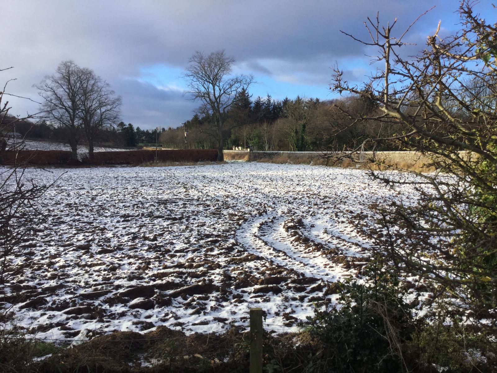
Some pics from friends in the Lordswood/Walderslade/Lidsing area. Some heavy snow at times and nice covering.
-
18
-
Parents sent this and woke me up. In Gillingham, Kent.
Meanwhile in Canmore...minus 20 and snowing.
Lol back to bed. I guess it's a start. Good luck.
-
6
-
-
59 minutes ago, Jason M said:
It can only ever be a few flurries. Air pressure is going to be very high tomorrow. Its actually surprising that we will even see flurries given just how far pressure is rising.
Though air pressure is rising, its less important when talking about sea effect snow.
It's more about temp differential from the sea to the air, along with other factors creating instability, fetch and wind sheer.
As a long fetch of cold air flows over the north sea, the fetch consumes an enormous amount of latent energy from the warm moisture from the water into cold air. High pressure or not. In fact some of the heaviest lake effect snow I've been in in Canada happened once a high moved in.
This further destabilizes the atmosphere, and generates convection.
As those convective plumes develop the upward forcing increased through frictional convergence and upsloping once it hits the land.
Admittedly higher wind speed (without sheer) increases snowfall rates.
I do think this could help areas inland as the upsloping increase snowfall rates (hence seeing intensity increase on the radar a few miles inland (hitting the north downs at 200-250m asl)
This is why I used to love this set up. If the models don't show these various factors but suddenly the real weather aligns last minute, its a surprise snownanza. Alternatively it can work the other way of course.
Here's hoping it's the former for the SE tomorrow. It's never going to be epic but I'm sure a few cm's would please most
-
4
-
 1
1
-
2
-
-
4 minutes ago, MAF said:
hello coops, how's bluebell hill these days?
seen this???
Snow showers for parts of Southern England Monday as cold easterly winds dig in
WWW.NETWEATHER.TV
A rather cold start to the new week, with raw easterly wind in the south blowing in some snow showers on Monday, bringing a slight covering perhaps in the southeast. The rest of the week will be mostly dry, less cold...Hey Mick, how's things?
Yeah good when I get back there always have good memories of the numerous snow events when others had nothing.
I think BBH will see a covering by Tuesday morning but it feels in my gut it'll be a West based event more due to wind direction
-
Surprised to see some SE bashing and p!ss taking about possible snow tomorrow elsewhere. At the end of the day I'm happy for anyone who might experience snow as its rare as non corrupt politicians these days.
It's an event tomorrow as there's a chance of snow and a chance of settling snow for some.
Who wouldn't get excited for that on a site where 90% of people are hunting for snow

Still looks like anything before Monday night is a bonus with the chance of some snow for heaviliy populated areas.
And as experience tells us sometimes it surprises us all with heavy snow and sometimes it doesn't. That's the exciting bit (and admittedly disappointing) if it doesn't work out).
-
4
-
-
11 minutes ago, colonelks said:
We’re in a little village on top of the North Downs, really hoping that we see some snow tomorrow. Met Office has us down for a few hours of heavy snow…
We typically do well in these types of setup.
Areas like Tatsfield/Knockholt etc should do quite well if it all aligns.
-
2
-
-
It's looking good for the SE. Looking at various outputs it seems like the wind is going to be NE at first which will help east/mid/north Kent and parts of EA but then it shifts more to NEE/E which moves precip from those areas to western kent/London region including possibly essex/Suffolk coastal areas.
Met Office don't seem too bothered by it but a lot of us have years of locals experience in this set up and have had snow when none was forecast.
Maybe they are expecting light showers and not much settling but still would have expected a low impact/low likelihood yellow. They're the experts though so what do I know lol.
Fun times. Good luck to everyone in the SE.

-
5
-
-
2 minutes ago, Kentspur said:
Mention of Hill snow on local Met update for London&the SE finally! But national weather not mentioning anything just dry. Well here's the latest tale from Ventuskys Icon precip charts-
Looks like a Kent&Medway& East Coast Clipper gradually becomes a bit of a Thames Streamer down to the south coast& IOW and a few isolated wintery showers further west as the winds turn more E of NE nothing major but would be nice to see it come off!
Yup could def see a few cms from this set up. Locally more for those in the firing line.
North Kent generally benefit well from this set up, from the streamer type formation as well as the advantage of having orographic lift from 0-200m plus in a few miles.
Though anyone on the north sea coast and further inland could benefit depending on wind direction and intensity and how far inland they get.
Usual spots at higher elevation could do well along North Downs of Kent from Biggin Hill along to Detling Hill, and in between like Lordswood, Walderslade, BlueBell Hill etc.
-
6
-
-
33 minutes ago, Battleground Snow said:
And there is the adjustment at Day 3 @sheikhy
Feel like we can take this run a bit more seriously in the 168-192 now range now.
Cold
 NE (ish) wind limited sheer good fetch North Kent streamer? Those in the SE (and Eastern UK) might start getting a little excited now
-
5
-
1
-
1
-
-
- Popular Post
- Popular Post
3 hours ago, nick sussex said:Still not possible at this point to forecast if there’s going to be any decent convection off the North Sea .
True and worth noting again for any one not in the know that the key elements for setting up good snow squalls off the North Sea are:
* Right wind direction ie Easterly or variances with NE through SE, depending on location.
* Temp difference of at least 13oC between SST and 850 temps. I.E Sea temp of 7oC requires minus 6 temp at the 850 level. The greater the difference the more unstable the more snow. 1987 is a good example.
* Good fetch of approx 60 miles min or more
* Minimal wind shear. I believe under 30 degrees is optimum, over 60 degrees and not much is going to happen.
There's other factors involving moisture/humidity etc but that's the basics.
So get a good high pressure in place, the right wind direction and temp and anywhere on the E/SE of UK can expect some nice surprises.
-
11
-
1
-
1
-
The blocked weather pattern continues with continued sun and warmth and above average temperatures for most of Alberta.
Edmonton due to see more temps above 30. The mountains a rather comfortable mid 20’s.
It’s been a fantastic start to spring after a relatively easy winter.
The only issue is it won’t help the numerous wildfires across western Canada - with about 25 currently out of control.
-
A wee bit of snow around at 11ish this morning in Killearn...
-
5
-
-
19 hours ago, Kirkcaldy Weather said: NSWWS_20180228_1112_R_Sn | Met Office UA
DIGITAL.NMLA.METOFFICE.GOV.UK
I don't actually recall the red in 2010, this is the same event I referred to earlier
Scottish travel chaos blamed on 'wrong kind of forecast' | UK weather | The Guardian
WWW.THEGUARDIAN.COMMet Office insists it gave adequate warnings of snow that brought central Scotland to a standstill"A spokesman for Transport Scotland said later that the Met Office alert level had remained at orange on Sunday night, and had not gone to a red alert."
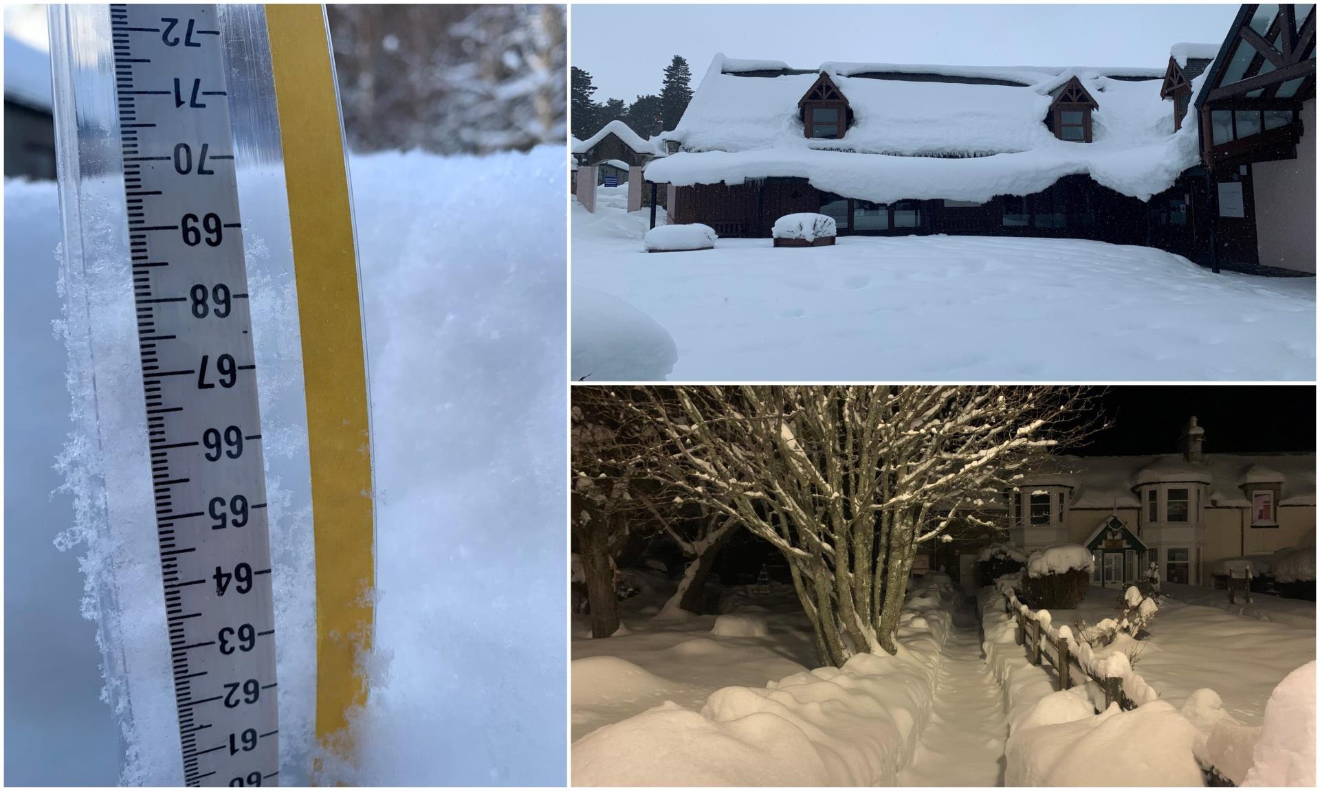
I think the event your imagining the 80cm was from the 2021 beast with a 70cm unofficial measurement in Braemar
'Record' snowfall in Braemar as weather warning extended
WWW.PRESSANDJOURNAL.CO.UKSnow levels in Braemar have now reached more than 2ft - breaking all previous local records. Keen weather watcher Chris Booth has measured 27.5ins (70cms)'The deepest lying snow was across Scotland
around Edinburgh, Fife, Angus, Kincardineshire and Aberdeenshire with depths of 20 to 30cm or
more, including 38cm at Aboyne, Aberdeenshire, 35cm at Fettercairn, Kincardineshire, 26cm at
Mylnefield, Angus and 23cm at Penicuik, Mid-Lothian.'Thanks everyone for responding. I remember the 2018 one as my brother was under it and received 45cm.
I think maybe it is the 2021 event. And as @Snowandrocks posted I can imagine locally there was some metre plus totals. Very impressive!
Thanks again


-
3
-
-
Would anyone be able to help? I’m trying to look at historical red snow warnings from the met office for Scotland. Specifically to see what’s been the highest snow totals ever forecast.
I vaguely remember one within the last 5/10 years or so. I think it was for NE Scotland for up to 80cm’s of snow. And if memory serves reports came in of huge totals.
Any ideas or am I losing it in my old age lol.
-
4
-
-
Approx 10cm’s at bluebell hill yesterday apparently. Always a good spot in marginal events at over 600ft.
-
3
-
-
My cousin sent me this from Bluebell Hill this morning. Said there was a few cm’s up there but nothing much elsewhere so settling snow line then was around 600ft
-
2
-
-
2 hours ago, Kentspur said:
There was a period of several years mid 90s and early 00s i remember Medway used to do well for snow my mum.moved there in Jan1992 and I remember countless times there being nothing or very little at dads in Dartford yet Medway always seemed to get more but I admit recent years its not been great for there. I remember getting stuck several times at my friends in Lordswood too when there was nothing on low lying areas down the road
39 minutes ago, snowray said:Those BFTE events in the 80's and 90's where very much as you describe there, as you went down the A2...
Bexleyheath.. nothing or a dusting
Dartford.. A covering
Northfleet.. 1 or 3 inches
Gravesend.. Thick snow, 3-5 inches
Medway.. Blizzards with drifting.
Eventually it would also snow around London, etc, but mid Kent by then would be snowed in. In 1987, one of my first jobs in London, my boss did not come to work for a week, a shortish sort of man, could not see above the snow that had drifted up his back door, somewhere the other side of Maidstone.
Growing up in lordswood from 70’s to early 2000’s, it was amazing for snow. If the wind hit just right from a NNE/NE it used to benefit from orographic lift, as well as it coming through the valley so nothing to stop it fizzling out. And always ended up with more than anywhere else.
In March 2004 we had a foot of snow and my employer in Chatham had barely anything and they didn’t believe me.
-
3
-
-
- Popular Post
- Popular Post
My brother sent me this pic from Killearn last night. Impressive.
I’ve not even seen northern lights this good in Canada.
Hopefully another good show tonight for you lucky lot.
-
16


Scottish weather discussion - Spring 2023/24
in Scottish Weather Discussion
Posted · Edited by Coopsy
Geeky Foehn alert.
I remember turning up in Canada during their first winter freezing at minus 20 when suddenly the wind picked up, strange clouds formed and within a few hours it was well above freezing. Then woke up to minus 20 again.
Ive since found out these warm chinook winds (as the Canadians call them) happen very regularly and are a god send in the depths of winter. Except for the wind speed. Which regularly reach 60mph.
In Alberta winter, west winds = chinook and nice warmth whilst East winds = upsloping and feet of snow.
Apparently, the adiabatic warming rate is approx 10oC per 1000m on the leeward side as the dry wind drops down.
So if its 9oC nearby then itll be approx 19oC under the affects of the foehn/chinook if the mountain height to location is approx that.
I'll try and did out some of the weird clouds I've photographed under the chinooks winds. Some are truly amazing from clouds cascading over mountains like a waterfall to multicoloured arches where the winds collide.
Also just wanted to say a belated thanks for all the snow pics. I was watching daily. Love the variations of weather in Scotland and the lifestyle. No matter where you are in the world, the weather never fails to interest.
Here's to a snowy February for everyone (planning on visiting mid Feb so if you can have a word with the Scottish snow gods for me I'd appreciate it
  )
)