


NApplewhite
-
Posts
209 -
Joined
-
Last visited
Content Type
Forums
Blogs
Gallery
Events
Learn About Weather and Meteorology
Community guides
Posts posted by NApplewhite
-
-
4 minutes ago, Ed Stone said:
This morning's GFS 00Z operational run is hardly conducive to heat & sunshine:

GEM is a nightmare
-
 2
2
-
-
Just now, NApplewhite said:i give up on summer im off to live in southern Spain.
Latest PPN charts - plenty of rain on the way
-
Just now, NApplewhite said:
I agree - look at the latest GFS for 2nd August
i give up on summer im off to live in southern Spain.
-
1 hour ago, mb018538 said:
Nothing has really changed has it? That brief glimmer of hope on the ecm last night looks like it was a false dawn. Cool and mainly unsettled for the foreseeable.
I agree - look at the latest GFS for 2nd August
-
21 hours ago, mb018538 said:
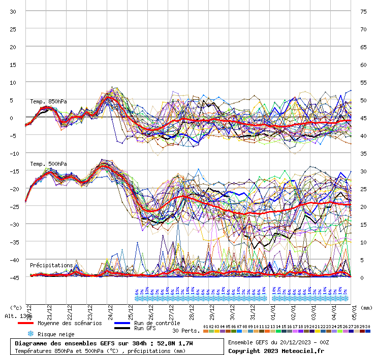
Crazy differences between the 00z and 12z at day 10 as you can see. 00z lots of northern blocking still around, 12z has it all gone with low pressure back over the pole. Much better prospects for the UK of the 12z is correct. CFS reporting very unsettled weather until at least 9th August and possibly until at least 16th August. Hints of something more like summer at the end of August 2021
-
1
-
-
34 minutes ago, Sunny76 said:
I think the second half of august will provide us with some very warm or hot weather for a change, with some more thunderstorms, but more widespread.
Some hints of slighly above average temps in late August
-
1
-
-
1 hour ago, Mike Poole said:
Heading back in the right direction at T168 on the ICON, I feel now might be a good time for the models to start smelling the coffee !
I’m still seeing a week of unsettled weather, not too wet on most days excepting the middle of next week, and then a gradual improvement.
2 weeks of unsettled weather ahead from Monday onwards. Here is the chart for 8th August from GFS. The trough hangs around for 16 days.
-
3
-
-
56 minutes ago, Mike Poole said:
ECM and UKMO at T144:
If anything the ECM pushing further north with the ridge, I think this run is going to be a good one, with a return to settled conditions, although not as hot, fairly quickly after the weekend breakdown. Despite what the naysayers say. I’d be backing UKMO, ECM combo here at this range.
Edit, then a little feature deepens at T168 and ruins it. Not there on UKMO.
Id like to get Tamara's view on all this. ! Its looking like a dogs breakfast of a summer apart from being very lucky with a 7 day hot spell. Is La Nina to blame for what is going to be a washout summer after Friday pm.
-
1
-
-
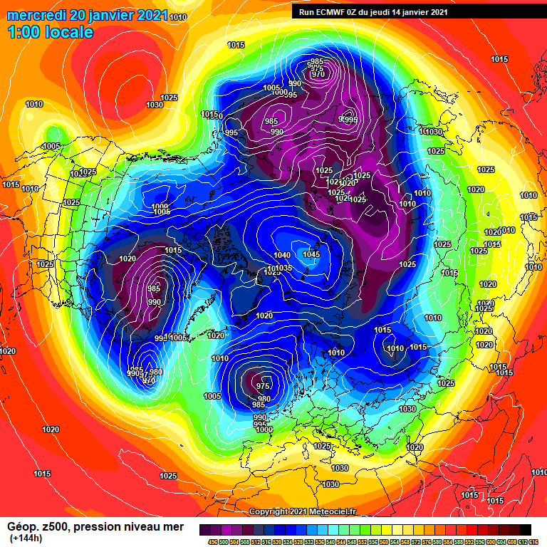
3 minutes ago, NApplewhite said:Plenty of rain in the ECMWF long range charts for next week!
Next week and the week after - low pressure dominates with high pressure in the Atlantic and across Central / Eastern Europe Very strong Azores high remains over the Azores! Trough over UK with NW winds and cool temps
-
2
-
-
11 minutes ago, Mike Poole said:
Anyway, all good with the nosing, so to speak, on UKMO T168
Plenty of rain in the ECMWF long range charts for next week!
-
8 minutes ago, Mike Poole said:
Anyway, all good with the nosing, so to speak, on UKMO T168
14 minutes ago, NApplewhite said:Trough gate is right! no sign of any high pressure for the next few weeks. Long range precipitation charts are showing 20-30% above average rainfall across England from now to end of September.
-
2
-
-
1 minute ago, NApplewhite said:
Trough gate is right! no sign of any high pressure for the next few weeks. Long range precipitation charts are showing 20-30% above average rainfall across England from now to end of September.
-
6 hours ago, mb018538 said:
Not great. Much more unsettled than the 00z run. Trough much closer making it wetter and windier. Side by side comparison below.
Trough gate is right! no sign of any high pressure for the next few weeks. Long range precipitation charts are showing 20-30% above average rainfall across England from now to end of September.
-
 1
1
-
-
7 minutes ago, NApplewhite said:
Im a pessimist and all the charts today are showing very high levels of rainfall accumulating over the next 16 days with averages of 50mm to 100mm across most of England and Wales and much colder weather (almost autumn like). The end of summer comes on Friday night.
Germany also to be hit my heavy rain over the next 10 days

-
2
-
-
7 minutes ago, Jon Snow said:
I’m finding the longer term GEFS 12z mean vexing.. ...never used that word on here before...however, being the optimist that I am, I’m hoping these GEFS 12z members are showing the way forward into August!

Im a pessimist and all the charts today are showing very high levels of rainfall accumulating over the next 16 days with averages of 50mm to 100mm across most of England and Wales and much colder weather (almost autumn like). The end of summer comes on Friday night.
-
1
-
1
-
-
1 hour ago, Man Without Beard said:
Well the UKMO is still very intent on bringing the plume back to the UK next weekend.
The model has been infamous since January 2013 when it owned the other models at D5 on a split trough at leading to a blizzard. Might this be its summer equivalent?
Would expect the ECM to follow very, very soon if it's right, though.
Could this just be the famous Kent Clipper. Its freezing cold here in Wales - temps of just 12 degrees at the moment in North east Wales with bitterly cold NW winds.
-
2
-
-
Sunshine in N. Wales today contrary to the forecasts of rain all day .
-
1
-
-
1 hour ago, Ed Stone said:
Aris-end of the GFS 12Z. Details are irrelevant, of course, but I'd like nowt more than loads of sunshine and 25C temps. But, it's the demise of the tPV remnants that I'm really liking:
Yes i cant wait for the PV to die! roll on summer! i dont believe this forecast its FL as usual
-
1
-
-
Following suit behind Punxsutawney Phil's prediction of six more weeks of winter, a blast of Arctic air infiltrating from Canada has ushered in the coldest air of the winter season across the Plains and Midwest. As a result of a few key atmospheric processes, this blast of cold air will likely settle in for multiple days to come.
Above-average temperatures that were observed across much of the Plains and Upper Midwest to start the month of February will quickly become a distant memory as temperatures some 30-50 degrees Fahrenheit lower will become commonplace over the coming days.
Residents of Rapid City, South Dakota may have had to double check the calendar to make sure it wasn't April this past Wednesday when the high temperature topped out at 59 degrees. A harsh return to reality has already begun to settle into the area as the high temperature only rose to 12 degrees F on Saturday and continue to drop even further by Sunday, with a high temperature of only 6 degrees expected.
"The press of Arctic air will coincide with a large southward lunge of the jet stream associated with a break-off lobe of the polar vortex and should give the frigid weather a free ride into much of the Central states starting this weekend," AccuWeather Senior Meteorologist Brett Anderson explained, adding, "Reinforcing waves of cold air will arrive through at least the first part of the week."
This southward shift in the polar vortex will yield bone-chilling cold for nearly every city across the Plains and Midwest this weekend and through a majority of the upcoming week.
A multi-day snap of cold weather will undoubtedly prove costly in the form of increased heating demands, as AccuWeather forecasters are calling for temperatures to fall a dozen or more degrees below average for several days. Aside from increased heating demands, bitterly cold air of this magnitude can also prove life-threatening for those caught outside for an extended period of time.
As of early Sunday morning, Chicago had observed its first sub-zero temperatures of the season courtesy of the polar vortex, which is the first time this winter season the city has done so. Through at least Thursday, low temperatures are expected to fall within a few degrees of zero in and around the Windy City.
Speaking of the wind, the bitterly cold air will be accompanied by blustery conditions at times, dropping AccuWeather RealFeel® Temperatures even further than what the thermometer will read.
Sunday will likely be the harshest day during the upcoming stretch in Chicago. Both the daily record low and lowest high temperature may be in jeopardy. The high on Sunday is predicted to be in the single digits, around 6 F. Subzero high temperatures are not unprecedented in early February, though they are rare. The temperature reached only zero degrees on Feb. 7, way back in 1893. The record low on Sunday of 10 below zero was set in 1875.
Many Midwesterners during the winter will often catch themselves saying that "This weather wouldn't be so bad if it wasn't for the wind", and they would be right -- to an extent. Although, bitterly low temperatures of this magnitude may even have some of the hardiest Midwesterners opting to stay inside instead of braving the cold weather.
Hypothermia and frostbite become serious threats in this type of air mass, especially with strong winds blowing or when people are trying to walk or jog. Not only for humans, but for our four-legged friends as well. For those that do venture out, extra layers of protective clothing will be needed to avoid these cold weather hazards.
Cold conditions of this magnitude can also lead to other issues such as freezing and bursting pipes, car battery troubles and potential winter kill of wheat crops in areas with little to no snow cover.
As if the low temperatures weren't enough, rounds of snow will also be a threat in some locations. Quick-hitting storms capable of dropping swaths of accumulating snowfall will traverse along a path from the northern Rockies into the Plains and Midwest into midweek.
Portions of the Plains and Midwest are expected to deal with multiple rounds of wintry weather alongside the bone-chilling temperatures. In the zone of heaviest snowfall, a swath of snowfall totals in excess of a half of a foot are expected in Nebraska by the end of the weekend.
Following the round of snowy conditions to end the weekend, another quick-hitting storm system is expected to ride along the heels of this storm system early this week. Many of the same areas dealing with snow to end the weekend can expect another fresh coasting of snow Monday into Tuesday.
Lake-effect snowfall will also be a concern in the coming days, as the Great Lakes still remain largely ice-free. As of Feb. 6, Great Lakes ice coverage sat at 12.6% coverage, with a majority of that being in the shallower bays. Through the upcoming week, it would come as no surprise to see the ice coverage double.
Despite the lack of ice coverage, it still has not deterred local ice fishermen from attempting to get out and catch a meal. Unfortunately, for some 60 or more ice fisherman on Sturgeon Bay, Wisconsin, ice floes became detached from the shore this past Thursday amid windy conditions, forcing a rescue effort from the Coast Guard and other local authorities. A similar scenario occurred on Michigan's Saginaw Bay Thursday evening, stranding at least 10 people.
-
4 minutes ago, JBMWeatherForever said:
Usually when watching for a noteworthy cold spell I watch the GEM with some nervousness as it is often more realistic and smells the coffee when the other models show Narnia. So the fact that GEM is showing the best solutions at the moment gives me more confidence than I would normally have that a significant cold spell is on its way.
Strange weather - just rain in Wrexham when the Met office were forecasting heavy snow a few days ago. Also where has the high pressure for next week disappeared to>
-
1 minute ago, NApplewhite said:
I am hoping that the low blows up and breaks apart as i hate snow and winter.
-
1
-
1
-
-
5 minutes ago, Mucka said:
144 comparisons.
ECM, GFS, UKMO
ECM looks good with the ridge but would have been nice if the low had tracked further S and not blown up. Maybe that will come this evening and we see a better and quicker cold flow.
GFS ensembles so much better than Yesterday morning and improving in deep FI from recent runs
Looking very cold over the next few days but its currently very mild in Wrexham - 8 degrees - temps dropping to 1 or 2 by this afternoon.
-
1
-
-
Just now, NApplewhite said:
Looking very stormy and bitterly cold next week
-
1
-
-
Looking very stormy and bitterly cold next week
-
1
-


Model output discussion 11th July onwards
in Forecast Model Discussion
Posted