


Comandante
-
Posts
15 -
Joined
-
Last visited
Content Type
Forums
Blogs
Gallery
Events
Learn About Weather and Meteorology
Community guides
Posts posted by Comandante
-
-
1 minute ago, SizzlingHeat said:
The low in the Azores is concerning for prolonging the cold. Looks to make inroads towards tail end of the week again....
Too progressive perhaps? Though it has been a recent trend to introduce less cold uppers to the south towards the end of next week. Too far out to really worry about anyway.
-
 1
1
-
-
Just now, snefnug said:
But they have made a quite marked statement and given euphoria on mad thread, what is likelihood as an outcome?
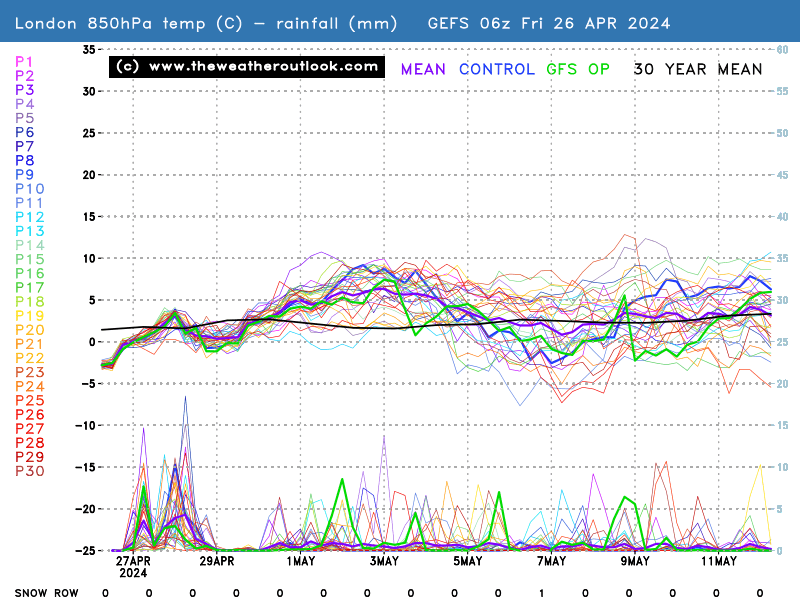
I think it this stage we are more likely to see the cold pool over the UK rather than south of it. The GFS 6z and most recent GEM, ICON and UKMO all back this up. Previous GFS and most recent ECM had the cold pool sinking south and a less cold (but still cold) NE to Northerly set in after a shorter-lived blast from the east.
The 12z's from the GFS, UKMO and ECM will be crucial this afternoon/evening I feel.
-
1 hour ago, snefnug said:
Beeb just now intimates that deepest cold will possibly push south to France?
It's a possibility and nothing more. That scenario has existed ever since this easterly was first modelled.
-
25 minutes ago, SizzlingHeat said:
However, more progressive again compared to the 00z and more akin to the gfs... Only going in one direction.
How is it more progressive when it isn't until Tuesday when the fresher air arrives, despite "the breakdown commencing Saturday"? Bizarre post!
-
40 minutes ago, SizzlingHeat said:
12z ecm. Saturday lunchtime. As expected, the breakdown has commenced. Showers and lots of cloud moving swiftly in. High uppers moving swiftly from west to east.

The very same ECM has warm uppers across the bulk of the country and very warm uppers still clipping the SE at midday Saturday. The warm air stays over the country through Sunday and indeed Monday too. It'll be a little cooler then yes but still above average.
Fresher conditions finally make it across the country on Tuesday,
-
2
-
-
11 minutes ago, SizzlingHeat said:
I fully believe that to be conservative at the very least. I would love that to be the case don't get me wrong but just expect the worst.
Can I ask for clarification regarding your opinion that we'll struggle to even hit mid twenties "going by the latest output"? 30C looks very achievable Fri and Sat especially in the favoured SE spots.
-
2
-
-
1 hour ago, SizzlingHeat said:
Doubt if 30 will be breached if I'm honest.
Any evidence or just a hunch? Even the BBC and Met Office forecasters are predicting the strong possibility of 30C anytime between Thurs and Sat.
-
1
-
-
4 minutes ago, SizzlingHeat said:
So... The downgrades have begun. Was as late as sunday/Monday yesterday now the latest 12z has the breakdown during Saturday. So the traditional 3 fine days and a thunderstorm it is then. Knew it was too good to be true. Never mind. It's still early days in the season.
I link you to the ensembles...
-
2
-
-
5 minutes ago, SizzlingHeat said:
So... The downgrades have begun. Was as late as sunday/Monday yesterday now the latest 12z has the breakdown during Saturday. So the traditional 3 fine days and a thunderstorm it is then. Knew it was too good to be true. Never mind. It's still early days in the season.
It's a cool outlier. Most show the heat lasting into Monday. It's a dangerous game assuming one run in isolation will be correct. Best to hang fire and see the full data set before getting the razor blades out.
-
7
-
-
29 minutes ago, Kentish Snowman said:
A really depressing forecast from Paul Hudson just now if you like your cold and snow!
I just cannot believe how much this cold spell seems to have imploded over the last 24 hours.
Can we at least squeeze out a covering of snow before the end of the weekend?
Edit - At least the latest ECM run gives us coldies some hope from around mid month!
It seemed realistic to me?
It is disappointing that those hoping for a good covering of snow are likely to be let down, but in fairness this cold snap didn't promise such an event anyway.
Snow showers most frequent in the east. I don't believe that any model forecasted more than a dusting of snow over the weekend. The GFS precip charts are low res so can give the impression of greater snow chances - whereas in reality we are looking at snow showers with the greatest chance of accumulation over eastward-facing locations at elevation.


Model output discussion - here comes the beast!
in Forecast Model Discussion
Posted
Can't see any backtracking now from this westerly nudge everything has had over the last 24 hours. Could well be heading for a westerly -NAO pattern.