


Frostbite1980
-
Posts
499 -
Joined
-
Last visited
Content Type
Forums
Blogs
Gallery
Events
Learn About Weather and Meteorology
Community guides
Posts posted by Frostbite1980
-
-
20 minutes ago, fromey said:
How accurate Is this? It is the cfs. Just curious not having a dig at you
To be fair it is like all models it can flip flop a bit, however I tend to watch the GFS (green lines) and the bias corrected runs as they are closer to the mark but even two of those just about reverse the winds. Its more looking at trends moving forward for me to see if the trend continues or indeed increases the chances but this is the first time I have seen 2 bias corrected runs reverse the winds at 10hpa.
-
 4
4
-
 1
1
-
-
4 minutes ago, supernova said:
Inconsistency run-to-run makes it hard for me to have even the slightest confidence in any of the output currently (longer range stuff in particular) so a good time to seek out trend-spotting posts from some of our more experienced members such as @Kirkcaldy Weather's insightful note above or the sort of stuff @bluearmy@nick sussex@johnholmes (amongst others) are always so good at sharing. Mid month and beyond still my main focus of interest especially if we keep seeing a potential Strat warming (tho nothing currently to suggest a full SSW) such as on this evening's GFS. Slim pickings for sure but not unfamiliar territory over recent years...

First signs, moving into Feb.........2018 anyone?
-
3
-
1
-
-
First signs of a possible SSW with the reversal of winds moving into Feb, I would take another 2018! One to keep an eye on.
-
1
-
1
-
-
I looked at the ens to see how many have some sort of snowy runners around 26th/27th and I found 7 with various degrees.
It will be interesting to see if future ens show an increase in this scenario.
-
4
-
-
4 minutes ago, goosey007 said:
ICON is bad though .....so I see it as a positive as its never correct flipping a flopping outrageously
The problem is the closer it gets to the event the more chance there is of it occurring and seeing we are only 5 days away.....
-
Can I ask a question please? I know that the op run is at a higher resolution but heard the control isnt, so why do we always refer to the op and control in agreement, when we might as well say the op and perb 25 are in agreement? Genuine question
-
1
-
-
2 minutes ago, minus10 said:
Yes...crazy 6z run for cold from gfs..
Jff..noted that four times the minus 10 line pays the uk a visit during the run....
...however i think the op has definately lost the plot towards the end of the month...hasnt it??
..how low does it want to go??
Only a 15 degree 850 difference between the control and op at the end

-
1
-
-
As I thought the op is very much at the bottom of the ens up to 192 and unless I am reading them wrong there are a fair few warmer options than the 0z. What makes me laugh is some of the ens have a lovely GL high and once again we are stuck in SWerlies.

-
1
-
-
Beautiful run by the 6z GFS however we need support from not only the ens but also the likes of ECM and UKMO before I start to take note. My take would be that this is either an outlier or right at the bottom of the pack, however i would be more than happy to be proved wrong. I might just have to take a few screen shots of this run mind

-
3
-
-
What a pretty site. I wonder where this month will end up!
Met Office Hadley Centre Central England Temperature Data Download.html
-
3
-
-
32 minutes ago, chionomaniac said:
I would say personally that we still have a bit of time on our hands - perhaps until the end of the year before upper zonal winds will start to propagate to the trop. Until this point the coupling will still be broken.
At every level except 2hPA the strat u wind is around average and this decreases the lower you get
2hPA
10Hpa
70Hpa
!00Hpa
Thanks for that Chio, does this mean that the chances of a SSW is decreasing if the trop couples in the new year?
-
5 minutes ago, Don said:
We will likely know all about it when the vortex does couple according to the CFS and looks like it's happening now?
Maybe Chio or Blue will be able to help answer this one

-
7 minutes ago, Don said:
No it's not!! A pear shaped winter?!! Going by that we can expect another PV of doom moving forward!
I Know the vortex isn't coupled but after the beating up of the upper vortex I was surprised to see this.......some of the CFS runs going for a record strength at 10 hpa
-
This isn't what you want to see if we are looking for a SSW?
-
1
-
-
36 minutes ago, RainAllNight said:
Have we had any op runs yet that keep the cold air that comes down from the north/northwest behind the big low circa 19th in place over us instead of moving it straight on?
See my post above, Perb 19, although after that, it goes down hill. This is the only ens that shows this scenario though.
Sorry didn't read your post properly, no, no op runs just the one ens.
-
1
-
1
-
-
- Popular Post
Perb 19 please
-
13
-
1 minute ago, Allseasons-si said:
UKMO 168

cold air pushing SE behind the low.
Will that allow heights to build over greenland though or just a transient NW flow?
-
34 minutes ago, Eagle Eye said:
The dynamical recovery of the AO probably has a lot to do with the unstable inertia that has propped up the -VE AO state losing it's support with a loss of AAM and therefore the Eddy's 'retreating' across the Northern Hemisphere battlefield as the Rossby energy transfer retreats to being mostly across the tropics with a flatter Atlantic to probably come into place by early next year. Signs that we could get an increase again in January but for now I'd treat it as signs.
The GWO supporting my view of the jet coming into line with the thermal wave northward transfer (of the jet momentum so the jet reverts back to normal) and eventual pattern flip into circumglobal ridges and it's been a general trend recently. Circumglobal ridges linked with Atlantic influence and mild and wet.
So beyond Christmas things may return back to normal with the occasional colder chance but I keep saying it...
Take this chance on the face of it and it is the best early Winter chance since 2010, as simple as that, we've still got till Christmas before any chance of severe cold setting in goes and even beyond then we don't know for sure that we won't get helpful background influences.
Do you not see a possible recurring pattern in January at the moment then EE?
-
1
-
-
- Popular Post
This is what we want to evolve!
-
12
-
 1
1
-
21 minutes ago, Gowon said:
I think they just reflect what the ensembles are showing, i.e., they follow the models and don't determine the outcome which means they are likely to change with every run?
That is correct, however it is the trend I am looking at.
-
2
-
-
The AO is trending slightly negative to now suggesting the loss of heights to our north and the NAO is trending neutral long term. Make of it what you will.
-
3
-
1
-
1
-
-
3 minutes ago, phil nw. said:
Much of N.Europe would be bitterly cold next week in this set up.
Notice the Scandinavian trough has been pouring deep cold south for some time.
The GFS 06z would send even colder air this way on any easterly.
That's the problem though, we just seem to be stuck under slack conditions and no sign of anything (yet) that will be bringing snow but to the usual locations, it would be such a shame to have such a prolonged cold spell and nothing to show for it but higher gas and electric bills.
-
7
-
-
Just now, Weathizard said:
Not sure that’s as good as this morning run though, it’s still decent but from that point I can only see a lot of the country pulling in milder uppers.
HOWEVER, longer term… this chart has Easterly/NE written all over it, so could be a little pain for long term gain.
Where have I heard that before..... Could well be true though
-
2
-
-
- Popular Post
My god peeps how much fun is this? Normally its how wet and windy it will be..... this is a real treat

-
11
-
1


.png.1ba69ebe8b8939943627ce4deee6e2b2.png)


.png.29d5297987de8757ae6a30ace4b05098.png)


Model Output Discussion - New Year and Beyond
in Forecast Model Discussion
Posted
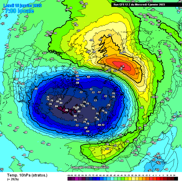
CFS Now picking up a reversal at 10hpa........although the end of Feb is not ideal this could well be bought forward if it happens at all!