


Grimers
-
Posts
184 -
Joined
-
Last visited
Content Type
Forums
Blogs
Gallery
Events
Learn About Weather and Meteorology
Community guides
Posts posted by Grimers
-
-
5 minutes ago, CreweCold said:
Might be a few days yet IMO before we see the ECM op start to suggest something of interest at day 10. I think we're at the stage now where the GEFS are starting to sniff out a change but may be jumping the gun slightly. Christmas to New Year week is where the interest is for me RE cold & snow potential...transition period few days leading up to Christmas.
Understood, however it seems to me that we may be chasing the cold weather a little too much, and that the colder conditions seem to be being pushed deeper into Winter. It's possible that your guess from a few months ago of a cold January and February could come true, but again it's all potential. We really need the charts to verify before we can start getting our hopes up too much.
-
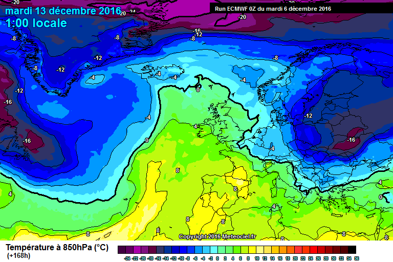
The only hope for coldies is if the ECM's output shown below comes true. Cold and dry sums it up. Though, as you can see the uppers aren't anything special. But, due to a high being present, cloud breaks will allow for potentially some harsh frosts to develop especially over inland areas. However, I don't expect anything too special due to the lack of snow fields.

-
The NAO and AO forecasts are either neutral, slightly positive or slightly negative suggesting milder conditions are likely to continue over the next few days.
-
 1
1
-
-
1 minute ago, Matthew Wilson said:
Will be interesting to note Rainfall figures this month as December is usually the wettest month of the year. I wonder if a drought month could be recorded? Pressure high on them charts which is a good sign.
That looks unlikely...
-
2 minutes ago, Ali1977 said:
Temps look pretty cold on that chart from the 18th, and I would think it will at least be frosty in any clear sky. A slight realignment of the high could start bringing something a fair bit colder still, not sure any snow just yet as the uppers around the high don't look conducive..
Over to the 06Z to see if it strengthens the idea!!
Well, I'd think if that chart is showing uppers then it'd be too warm for snow anyway.
-
According to the GFS and ECMWF, a fairly mild outlook with a brief interlude of cooler conditions on Sunday before a return to mild conditions seems likely.
Unfortunately, it seems that a mild more than a cold Christmas period is likely and as others have stated in the previous thread, milder conditions are likely to win due to our position and being surrounded by warm seas. However, as you can see from the last chart on both the GFS and ECMWF, I still think there's a chance of colder conditions being present for Christmas.
-
4 minutes ago, northwestsnow said:
Hmmm 133mm of rain for NW Scotland, not good...
Yes, rethinking this I reckon surface water and flash flooding could be an issue but more widespread and river flooding is unlikely.
-
7 minutes ago, northwestsnow said:
potential for flooding...
Hmm, I think flooding is pushing it, yes there may be for parts of NW England and Scotland, but due to low ground water levels, there won't be on a national scale like we saw last Winter.
-
Well said. I have to admit, I did post a while back explaining what could happen around the festive period. So, you're right, using the evidence we already have and then trying to guess what could happen is where all the interest lies.
-
2
-
-
Just now, Frosty. said:
Although the Gfs 12z becomes mild from next midweek, it doesn't look super mild with temps in the mid to high teens celsius like we saw last December, temps look nearer to 11-13c range with some sunshine but also bands of rain, especially affecting the north.
Still, you've got to admit the temperatures shown by the GFS aren't far off this time last year and we don't want anything like we had last year. Anyway, back to the here and now...
-
1
-
-
@Mucka, that's all well and good. But, I wouldn't want to set my expectations too high anyway in case of dissapointment. I would hope that I don't class myself as a glass half empty person, but if we became too hopeful then surely this thread would turn into a melt down situation when what we've set our hopes up for doesn't come to frutition. It's probably best that we try not to predict what could and might happen ahead of what the models show, it's already hard enough as it is trying to work out what could happen in the forecast period at the present time.
-
3
-
-
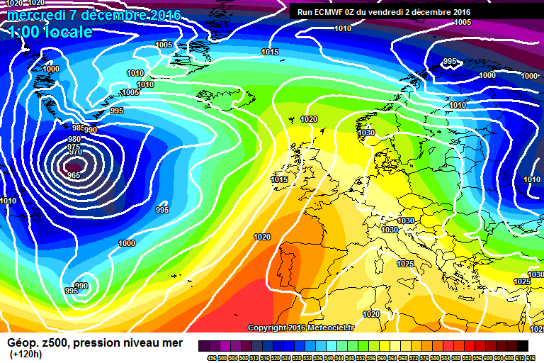
There's so many questions that could be asked about this chart. A ridge of high pressure tries to build in from the W but whether this manages to successfully build in and settle things in down for Christmas can only be answered over the coming days. I'm somewhat doubtful that it will calm down in time for the festive period, it looks fairly active over Greenland, not where the coldies want it to be.
-
48 minutes ago, northwestsnow said:ecm ens, not as bad as i feared, seems the ops this morning were indeed worse case scenario for coldies..
Yes, it could be a lot worse but it could also be a lot better (not trying to dig here). The NCEP and ECMWF are predicting slightly above average uppers on that chart. I would hope that there's a slight upgrade in favour of coldies' wishes.
-
1 hour ago, mountain shadow said:
Not one of those show the Atlantic taking hold. Those show the Euro slug High taking hold.
Sorry, but they do. If it hadn't the charts wouldn't look like that. The euro high has been pushed E due to a low moving N to the W of the UK bringing milder conditions from the Azores.
-
The GFS, ECMWF and UKMO model all show the Atlantic taking hold.
-
4
-
-
It's interesting how the CANSIPS doesn't show a huge block of cold air over the USA as some mean and long range models have been showing.
-
7 minutes ago, jvenge said:
CANSIPS Monthly is out. Worth pointing out that it is pretty much out on its own with this.
If I read the charts right, is that suggesting average temperatures and higher than average heights for to the W of the UK? If so, this would suggest a more anticyclonic flow for especially for N parts of the UK but dry and cold conditions for S parts of the UK.
-
I think I must bite the bullet! The GFS has been hinting of a return to milder conditions for a few days now and the UKMO is now starting to pick that up both in their model and forecasts. As others have stated, predictions of milder conditions are more likely to come to fruition than cooler conditions. I think we're just going to have to "ride the storm!"
-
4
-
-
The latest GFS run brings slightly colder air from the E.
-
@Changing Skies, well said. I think some need a sense of realism instead of fretting over different model/runs. Overall, the models are showing a cooler than average Winter. Also, since models were invented, there will be big differences between them especially in FI and when there's the potential of cold conditions.
-
2
-
-
Just now, feb1991blizzard said:
Its not (I know it says it) - this is March.
Yes, just spotted it, thanks.
-
29 minutes ago, IDO said:
I am no killjoy but when you see CFS rolling out horror charts like these for Winter you know it may be a long winter where the word "potential" will be a byword for disappointment:
Dec
JANFEB
That's March not February.
-
3
-
-
5 minutes ago, Ali1977 said:
Knowing what we know from the likes of Ian F , I fail to see how anyone can be dissapointed with the look of the NH at day 10 on the ECM, no snow forecast in the next 10 days but the potential is clearly there with the lack of PV etc...stay cool and fingers crossed by the weekend things start looking up.
Agreed, though I'm concerned about lows sinking to the E of the UK giving snow to Scotland but not necessarily anywhere else.
GFS starts cold but turns milder later, still just about in FI but it could come to frutition... I hope not.
-
Just now, Frosty. said:
I'm trying to bring some cheer to snow lovers, the extended Gefs 12z shows some wintry runs and some close to exciting possibilities!
Yes, I've just been looking at the GFS, ECMWF and UKMO and I'm struggling to see any sign of snowy conditions. However, the GEFS seems to be the outlier this time round.


Model output discussion - 5th December 2016 - Into Winter we go
in Forecast Model Discussion
Posted · Edited by Grimers
After the gales of Christmas Day, things start to settle down as we head towards New Year as an area of high pressure establishes itself across the UK and continent potentially bringing some milder conditions but also some frosty nights especially across inland areas.
I have to say, I wouldn't mind what's showing over Scandinavia and W Russia, that would be something else! Us coldies would be in heaven! However, dare I say, this chart is not far off.