


Matthew.
-
Posts
1,259 -
Joined
-
Last visited
Content Type
Forums
Blogs
Gallery
Events
Learn About Weather and Meteorology
Community guides
Posts posted by Matthew.
-
-
2 minutes ago, Summer Sun said:
No doubt about it the SSW has shaken the weather patterns to tatters since late Feb
2018 will go down in memory as the year of extremes without doubt
Interestingly 1989 had a SSW in February too and that’s the best overall May to August bar 1959 maybe 1976
-
 1
1
-
-
If these conditions continued to the end of August it would be the summeriest May to August and the best summer bar 1976. Can it continue another 9 weeks? 2006 had a great June and July but lost out because of August and it 2003 July the same problem and 2013 similar in different periods. Wheras 1989 and 1995 will be harder to beat with smaller periods of unsettled conditions. What a summer though!
-
-
In 1976 temperatures exceeded 32c on a 15 day run with 5 days at 35c I’m getting a little nervous with the latest model runs. Pleased I don’t live in the south
-
I think what’s remarkable here is the perfect position of the high pressure. In 1995 it was just too far west until a few days in. 1976 though was perfection and we might even match it for 1 week. Can we make it 2 like it did back then? This year has been a year to remember!
-
7
-
-
The models this morning are giving the impression of the best last third of June since 1976. Outstanding charts this morning again with 22c-30c across the board easily from sunday.
Edit: 35c somewhere from ECM on friday

-
5
-
-
Well from the runs tonight I wouldn’t be surprised some areas seeing the maximum break in terms of sunshine at 135hoursish between tomorrow and the end of the month. Incredible stuff! Brings back memories from 2013
-
3
-
-
45 minutes ago, Singularity said:
...with the exception of summer 2018
2 or 3 day spells of this is pretty typical in most summers but to get an extended period is much rarer. In fact I can only think of 4 summers to do so since the 00’s such as 2003, 2006, 2013, 2018 maybe? Exceptional stuff with the remarkable model agreement at a textbook time
-
Once again the model consensus is for another extreme event of 2018 with a June heatwave with bags and absolutely bags of sunshine in the last 7 days days. All models once again with mediterranian style weather. Ukmo has a bullseye high
-
4
-
-
What a fantastic year of model watching this has been! Hope the ECM is on the money
-
1
-
-
GEM, GFS, ECM, UKMO say HEATWAVE ON THE FROM SUNDAY!!!
-
6
-
-
The best summers do see the trademark of high pressure in the last third of June with dry the dominant feature of the month
-
3
-
-
West Wales is racing ahead with sunshine at 100hours whereas some parts of the east have had a third of the value to the 10th
-
2
-
-
I think notable thing will be how dry this June has been looking ahead. Many of the best summers had dry junes
-
2
-
-
A good run for next Monday from ECM
-
4
-
-
Please delete
-
That low for Thursday will really sweep away the cobwebs and North Sea cloud
-
2
-
-
I’m sure someone a couple weeks back posted that trades would surge and with a lag effect around middle of June but then looked like easing off so expect the expected really. Maybe things should improve last week of June by what I saw back then
-
1
-
-
It doesn’t look like the year of Greenland blocking either so I can’t see a poor summer without this feature
-
1
-
-
Eastern areas will really notice the difference once the dull drizzly skies are replaced by fair weather cloud and a real warmup for places close to the eastern coast. 3 weeks this North Sea pattern has held!
-
5
-
-
10 minutes ago, mb018538 said:
Now that's what we want to see....proper Azores high building!Lots of low pressure around Greenland too. Much potential there!
-
1 minute ago, mb018538 said:
Another day, another plot twist.
All of the models this morning are scaling back low pressure influence - now shown to be out to the NW, with more of an Azores ridge meaning it probably won't be that bad, and more of your traditional UK NW/SE split in terms of settled weather.Yes quite a chang. Be interesting to see where the ECM goes further on
-
I can’t see anything concerning just yet. Looks like we finally pick up a westerly flow but the Azores ridge looks poised to bounce back on the ECM
-
6
-
-
9 minutes ago, 38.5*C said:
The GFS and ECM 12z are both quite frustrating next week. Back to a progressive Atlantic. But it can be expected in mid-June, the european monsoon "return of the westerlies". But how long it lasts for is the main question. I have a good feeling that the Azores will meet up with Scandinavia just in time for July then we can settle into a decent summer pattern for high summer.
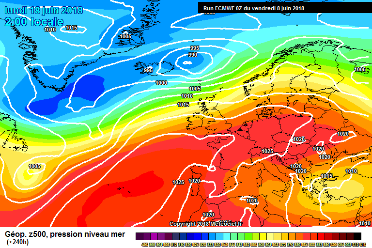
The unsettled return does just like a blip. There’s many signals out there saying we may be in for the warmest summer of the decade. ECM 240 sees a quick return of the Azores ridge. Because we’re at solar minimum the meridional jet looks like continuing and high pressure looks non existent around Greenland. A few similarities to the Ssw year of 2013
-
2
-
 1
1
-


Summer 2018 - Moans, Ramps, Chat etc
in Spring Weather Discussion
Posted · Edited by Matthew.
For my location we had the best May in living memory and summer is on course to be one of the best of the century only behind 2006, 2013. Depends on what August is like but I can’t see it betterin them 2 years here. 2003, 2014, 2016 could be beaten though.