


coldcomfort
-
Posts
1,525 -
Joined
-
Last visited
-
Days Won
10
Content Type
Forums
Blogs
Gallery
Events
Learn About Weather and Meteorology
Community guides
Posts posted by coldcomfort
-
-
41 minutes ago, Man With Beard said:
This rain band keeps moving, but if the Euro4 is right this morning (big if!), someone somewhere is going to have a very soggy BBQ tomorrow

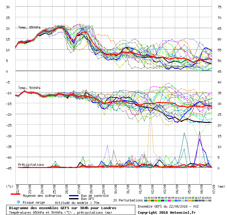
Can't remember the last time I saw such a large variation across such a short period, in fact the closer the event gets the greater this disparity becomes across the models. GFS now pretty much kills any rain completely away from the far SE, whilst the Euro4 moves it up to N England and as you suggest gives some places an absolute pasting!
-
Any Saturday heat even in the SE now looks to be on very shaky ground indeed, in fact average to slightly above looks the call there, with the vast majority of the UK looking cool, even very cool under the rain.
Thereafter with LP sat between Scotland and Iceland the final week of the month looks distinctly uninspiring, at least according to GFS, so we now look towards the upcoming hurricane/tropical storm season to shake things up and hopefully offer all of us some decent spells during the first half of Sept.
-
 3
3
-
-
8 minutes ago, Gordon Webb said:
I tend to agree with most of this , the only really hot weather after today will be mainly in the SE , not saying the weather will be terrible elsewhere
Indeed, I never suggested terrible, what I said was very average.... which in late August is generally pretty decent or at least usable.
Come 7.20 this evening the ECM will have shunted much of Saturdays heat further towards the east imo, but even if as GFS suggests 850's are in the range 15-19c across the SE, more in the way of cloud and even some thundery rain will supress maxima by several degrees imo. Elsewhere 16-23c looks a fair shout, with 16-22c not far off he mark for many on Sun. How that isn't 'very average' is a mystery to me!
-
2
-
-
4 minutes ago, knocker said:
It doesn't. See my earlier post.
And what odds do you place on that chart being similar at 7.20pm this evening Knocker.....I will say 20-30% and I suspect even that will be optimistic.
-
17 minutes ago, MR EXTREMES said:
well then jo forecast must be ready for the bin!
with all the expertise on here then id say coldcomfort that u seem to be the minority going against everything the models and experts are suggesting.
the ecm pretty much says low 30s
gem pretty much the same low 30s
navgem to suggests low 30s
could be some fireworks to imported heat unstable air could be some spectacular storms although hit and miss cool down out into fi so things likely to change in later model runs the low 30s i feel is a done deal as always beware of fi.
ive noticed how the gfs progressive in sweaping away the heat although it does keep things humid into the weekend bank holiday well could be fine or could be a washout.
and mid to high 20s for almost half uk
Maybe if you read my post correctly you would understand the point I'm making...that said I'm happy to clarify it for you once again. I said 'outside the far SE (for clarity based on the UK this means roughly southeast of a line from the Wash to the IOW, not just Kent and Essex) the very average weather will continue across the weekend, much as it will across the remainder of this week after today.
Perhaps using the charts above posted by yourself, you could show me why/how I'm so far off the mark with this claim, because to me the odds favour distinctly average conditions for 70-80% of the country between tomorrow and Sunday.
-
1 hour ago, Man With Beard said:
For Saturday: A closer look at the ECM 00Z using the Icelandic Met shows it is reasonably good for northern Scotland but a little fresh, warm and stormy from Central Scotland down to about Manchester, and a sizzler for all areas south of that, quite possibly being the hottest day of the week with temperatures between 30C and 34C fairly widely in this area, according to this one run:
Couldn't disagree more MWAB....pretty much zero chance of verifying as shown, indeed outside the far SE the very average weather will continue across the weekend, much as it will across the remainder of this week after today. There really is unworthy amount of hype surrounding the weather atm, with the vast majority of us well outside the heat zone - take Camborne for instance where 20c looks a push on any day after today..... and Camborne as Knocker will attest is a long way south of Manchester. Things have to be kept in context here imo.
-
1
-
-
13 minutes ago, Man With Beard said:
The desire for a second round of heat on Saturday has gathered pace quickly
Note some runs in there that keep it very hot for 3-4 days without a break. I'm pretty sure the hottest runs would see us up to 35C/36C.
As it is, I expect the ECM would get close to 32C, the GFS would exceed 32C, and the GEM saves it for Saturday when it could reach 35C
No everyone lives in London though MWAB, for many the reality of the next 3 or 4 days is very different...chalk and cheese in fact.
-
6
-
-
Still plenty to be resolved re detail across the working week......however what it ultimately boils down to is plenty of warm/very warm weather for most of England, but the far west of the country, along with much of Scotland, Wales and N Ireland look set to miss out on any heat (and in some cases even any warmth) once again. As for the BH weekend, still far too early to call with any confidence, but if there is to be any dry, warm and settled weather on offer it's looking increasingly likely that only the SE of England will see it, with 80-90% of the UK having to endure further distinctly average weather.....as per the summer in general.
-
1
-
-
3 hours ago, Matthew Wilson said:
A pleasant fine settled bank holiday for England and Wales as settled conditions nudge in. Hopefully this holds and lots of sunshine is on the cards.
Absolutely no point whatsoever in looking that far ahead atm, especially with GFS, which time and time again recently has been proven reliable for only one thing post T+120hrs, i.e building hopes of heat/plumes, only to dash them 3-5 runs later.
-
2
-
-
5 hours ago, 40*C said:
18z is a backtrack on next weeks heat, the low out to the west nudges in and squeezes the heat into the East, so rather than a N/S divide its more of a E/W divide - Blackpool at just 19c wheres in Great Yarmouth its 30c. I think we're seeing the same typical model scenario as last week.
Indeed, it didn't take long did it, with the 00 run franking the 18 and demonstrating another all too predictable climb down from GFS.
-
1
-
-
ECM and UKMO again pretty much on the same page in the 120-144hr range, leaving GFS once more ploughing something of a lone furrow, so expect it to fall in line sometime across the next 2-4 runs. It's looking very much like a repeat performance of what we saw with the plume that never was early this week, but it's a bit of a mystery why GFS seems to be struggling so much at this range compared to the other big two. On a positive note many central and eastern parts of England should again see a couple of days in the mid, locally high 20's next week, but for the vast majority of the UK it's shaping up to be another 'close but not close enough' event imo.
-
4
-
-
Better than many recent August yes, but next weeks warm up looks like being another fairly brief affair according to UKMO/ECM, and one which is again largely confined to England, particularly central and eastern areas. GFS looks a very optimistic interpretation of things in holding off the breakdown until next weekend, so whilst it might well pan out correct I expect it will drift more towards ECM once again across the next 24-48hrs. Probably wise not to forget just how bullish it was about the last plume and it's 22-23c 850's...
-
1
-
-
Still no real point in attempting to put lipstick on a pig, the 12 GFS is another out and out stinker bar a rogue and very unlikely plume, so IF it verifies we can pretty much write off the final fortnight of meteorological summer...or am I simply guilty of putting another unduly negative slant on things?
-
1 hour ago, No Balls Like Snow Balls said:
Some of us like pigs lol :-). Personally looking forward to some autumnal rain and gales.
Risky admission...
Anyway to each their own - fine, dry and warm means I make money, unsettled with rain or showers means I lose money....so it's a no brainer for me!
-
No real point in attempting to put lipstick on a pig, the 06 GFS is an absolute out and out stinker, effectively writing off the final fortnight of meteorological summer IF proven even close to being correct. August is currently looking a classic game of two halves, the 1st being considerably better than the 2nd!!
-
3
-
-
Well all I can say this morning is make the most of the coming 2 or 3 days. Thereafter and despite the GFS op we appear to be staring down the barrel of a really disappointing spell of late summer weather, indeed that description is probably being very charitable as things currently stand, with charts that wouldn't look out of place in late Autumn
-
1
-
-
06 already looking less plumey still at 120hrs, with the breakdown from the west also looking a tad more progressive. At this rate even the E/SE of England will be seeing a blink and you'll miss it event....
Looking at Tues cloud and potential showers I think even a 30c somewhere is starting to look a bit of a stretch, all in all very disappointing imo.
-
2
-
-
1 hour ago, knocker said:
Morning campers - a brief look at this morning's GFS starting with the weekend.
Midday Saturday sees the UK in a cool NW airstream with a few showers in the north otherwise mainly dry. But HP is nudging in from the SW and 24 hours later a high cell is centred over the Irish Sea so a dry cool day for all. At the same time, in this quite mobile pattern, a frontal system is girding it's loins out west.
From this point the HP moves east, then north, accompanied by a similar movement from the front ( just east) on which small perturbations form, so that by 18z on Tuesday the front lies just to the west of the UK. This scenario briefly introduces some WAA from the south so that the southern part of England will, again briefly, be quite warm with temps around the 28C mark.
The front continues the movement east bringing thundery outbreaks and possibly some substantial down pours to some areas over Tuesday/Weds. Eventually this system swings on it's axis and ends up over N. Germany as it slips under the high pressure which is now to the NE with once again the HP edging in from the south west.
Overall the next seven days are quite dry with the only substantial rainfall in NW Scotland. This is of course not taking into account possible localised rainfall from convective activity next week.
Whilst the forecast for the weekend is heading in the direction I've been suggesting for a few days, I'm not sure I'd describe both days as universally cool Knocker, especially across the southern third of the country. Here average to rather warm look a more accurate assessment to me based on the latest outputs, average to rather cool would then cover the middle third, with genuinely cool conditions only prevalent across much of Scotland and N Ireland.
Where we are this morning however is a long, long way from for very warm hor d'ouevre weekend that was set to precede a significant Spanish plume for early to mid week, indeed everything now looks very disappointing from a heat perspective, pretty much as one or two suggested as long as 3 or 4 days ago.
Hopefully IF this all pans out close to current projections another lesson about chasing eye candy charts a week hence will be learnt, but some how I doubt it!
-
1
-
-
10 minutes ago, ajpoolshark said:
good grief, look at the NMM output!....It is not misleading in the slightest!...If you think it's misleasding then I honestly suggest you go and look up the definition of the word 'misleading'....I have no agenda, and post only factual information when I do post, no guesses, hunches, or random interpretations.....It quite clearly shows the forecast temperatures I quoted in the south and south east.....If you can't see that, then I honestly recommend a visit to specsavers
Firstly I don't think there's any need to get personal and question my eyesight. Secondly you missed the point I was making. I was not questioning what the NNM model was saying, indeed I pointed out that GFS was going for even warmer temps across a very small area of the south, my point was focusing on these higher values no more paints a representative picture of the UK as a whole this weekend than mentioning the temps in Shetland. The comment was not aimed at you directly, it was just a general observation of how things can become skewed if we don't look at our whole island.
-
5
-
-
7 minutes ago, ajpoolshark said:
whilst the NMM medium resolution progs temps of 25C plus for friday/sat/sunday in the south/south east with not too much in the way of cloud and no ppn....quite a contrast of just goes to show that one model output's brings disappointment to some.....other model output's bring nirvana
GFS goes for 25-26c in the extreme south on Sat and 27-28c on Sun, but only across a very small area, so quoting those kinds of values is just as misleading as quoting the 11-12c expected in Shetland. On balance temps this weekend look set to be pretty close to average for the southern half of the UK and a little below average across the northern half...with the near standard local anomalies.
-
17 minutes ago, Karl. said:
I agree with coldcomfort, he's not being pessimistic he's being realistic about the weekend which now looks ordinary with temps only reaching 23c in the south / southeast on sunday. There looks like being a lot of cloud and even a few showers around.
Indeed, I think we all have to be mindful when posting that this might be a relatively small island but it is often very meteorologically diverse, with much of the northern half of the country only seeing temps somewhere between 13-18c during the rest of this week and right across the weekend.
-
2 minutes ago, Man With Beard said:
Good to have you back Knocker.
Well this morning's ECM sees trough disruption throwing a spanner into modelling. A mini-low appears over SW England, splitting in between heights to the north and south.
Now normally this would just be a case of who gets the rain - SW, central, east or north - the type of situation where those forecasted to be wet at T48 might end up dry by T0, and vice versa. But when this much heat is around -
- there is the potential for some incredible contrasts in weather that may not be fully forecast-able until very very near T0. The difference in modelling between 22C and 32C will be very small.
I think we're pretty well set now until Tuesday. But Wednesday onwards may end up a forecasters nightmare if the tendency to split a trough near our SW continues.
Coldcomfort - I wouldn't be so pessimistic - I think Manchester will get lows 20s over the weekend (Saturday a little dodgy but might be ok) and high 20s are possible any day from Monday to Wednesday, even Thursday if that low is a little further south. You'd settle for that wouldn't you?
Not being pessimistic at all given the charts in front of me. Low 20's is pretty much ave for Manchester in mid Aug, but upper teens perhaps 20c looks about the mark on Sat, maybe a degree higher on Sun...ergo average. Clearly a warm up early next week, which I think I covered fairly well, we just need to see if ECM is onto anything regarding the trough disruption the SW (a genuine possibility imo), so as ever more runs needed.
-
1
-
-
Well what was originally a warm/very warm weekend for may now looks set to be another rather indifferent affair, as does Monday, with temps close to normal for many across England/Wales and pretty cool for Scotland/N Ireland. Tues/Weds see temps lifting into the very warm, locally hot categories for inland parts of England and Wales, but any warm up across Scotland and N Ireland still looks fairly muted, especially north of the central lowlands.
Yes nice to see, but to my eyes we are still only looking at a localised heatwave Tues/Weds across much of England and Wales, with those north of the border and across the water in NI possibly being able to go down to only 1 jumper for 24hrs early next week....
-
5
-
-
40 minutes ago, ajpoolshark said:
It's a jolly good thing that the model output doesn't dictate the weather isn't it?.............The outputs are ebbing and flowing as usual when one considers all the variables that have to go into place for each data set especially when one takes into account how the verification percentages drop off rapidly the further the algorithms predict future timescales. With that in mind, I do find it a touch ironic that some are looking at a breakdown of any warmth/decent weather before the warm/decent weather is actually showing its hand in the here and now!
It's a model discussion thread is it not? Therefore if people wish to talk about a breakdown which is supported by charts from said models, does it really matter what the current weather setup is?


 Anyway to each their own - fine, dry and warm means I make money, unsettled with rain or showers means I lose money....so it's a no brainer for me!


Model Output Discussions 12z 03/05/2016
in Forecast Model Discussion
Posted
Another marked variation in the GFS/ECM outputs post T+120hrs, which then become ridiculously different post T+168hrs. Once again I suspect the reality come this time next week will lies somewhere in the middle, but I'm hoping ECM is wrong for obvious reasons!