
- Popular Post


Tom D
-
Posts
1,346 -
Joined
-
Last visited
Content Type
Forums
Blogs
Gallery
Events
Learn About Weather and Meteorology
Community guides
Posts posted by Tom D
-
-
Just had a brilliant storm here. Took some videos but the sound quality has failed. Will show the link anyway.
We had 18mm in an hour from that. Some cracking lightning and instant cracks of thunder. Been waiting for that after the last few days of near misses and disappointment!
https://plus.google.com/u/0/photos/103402818696004712865/albums/6038215440490078401
EDIT: Sorry it's the right link now.
-
 1
1
-
-
-
http://imgur.com/dHeE38a beautiful sky here in Herts
-
-
Language WarningI didn't swear in this one! I've just uploaded a video of the moment the squall line came through here. Hope it's turned out OK.-
5
-
-
Some trees down round here, but mostly branches (some very big) strewn around. Bright and breezy now! Andrews field (nr Braintree, recorded a 79mph gust. Probably close to that here 15 miles away.
-
1
-
-
0824:
BBC weather man Simon King says: "Strongest winds now across Kent, East London and Essex. 8am gust of 80mph just outside Braintree."
That confirmed that we had the same line of squally winds about half an hour before. Really cool to watch. Hope nobody is hurt.
Wish I could post my videos of the moment the squall hit. Will try to upload a vid later. Going out and about to see the damage now.
Pics don't quite do the intensity and strength any justice.
-
Caught some videos and pictures as the squall line went over. My word trees can take a lot.
Album here: http://imgur.com/a/WiKIA
-
2
-
-
Wind is crazy right now. Must be gusting 70 mph. Fences down.
-
Wind really picking up now.
-
Not a breath of wind here. Looks like we'll get an exceptional rainfall though.
-
Cannot believe it's still raining this morning. My rain catcher has recorded 34.9mm in the last 24 hours, but I think it's been raining for longer than that.
-
That little storm has woken me up! Lots of lightning actually, some very close. Nice surprise to be woken up by thunder,
-
A video capture of some lightning from yesterday. Have to admit we've been spoiled with thunderstorms over the past week or so.

-
We're in a lull here, frequent lightning to the north east, north, north west and now coming from the south. Great to watch.
-
Yes please to 216
Its early March so ill take something like this...better than early warmth
Check out that cold pool over the southeast USA... snow on the Gulf Coast in March?
-
Glorious ECM again this morning. Hope this trend continues.
-
It's been a decent spell here in London but definitely not remarkable.
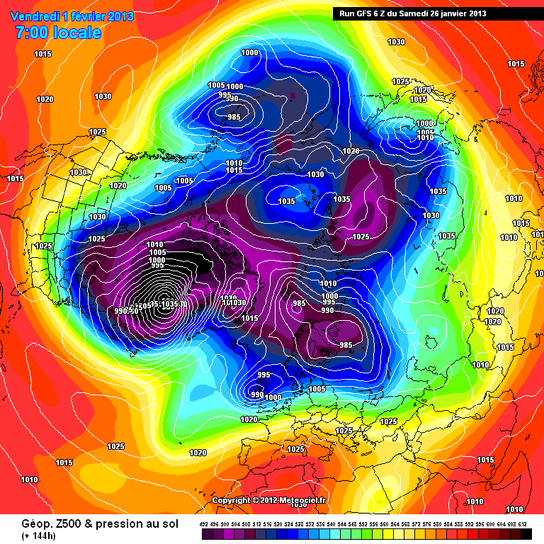
Not far from London here in Herts it's been fantastic IMO. We've had snow on the ground for 14 days, up to a depth of 14cm last Monday and currently still 5cm in places. It's been consistently -2c to 2c for two weeks too, with the odd overnight -10c or -8c. What is most remarkable in my view is the lack of sunshine - it's been almost completely overcast and grey during the spell. This morning was refreshingly bright. Also IMO what is remarkable is that, despite a lengthy cold spell for most of the UK, the CET will probably recover to only just below average because of the swing between much milder and much colder than average conditions.
Anyway, back to the models and it's hardly encouraging to see charts like this coming into the +144 timeframe. I hope others agree there's potential BUT given the strength of that vortex over Canada/W Greenland we may be stuck in this new regime for a while.
-
Just a quick one. Encouraging signs on the GEFS regarding the wider synoptic pattern. Low confidence at the moment.
What I see is a (low confidence) trend to high pressure building over Reykjavik and low pressure in Scandinavia (a reversal of the present pattern).
Which gives us this kind of set-up.
-
Although GEM has performed very well at handling this cold spell.
Have you any evidence to back up this claim?
-
Ecm lookin very similar to gem at 72 hours
Unfortunately the ECM has a much greater data input than the GEM (or so I would have thought).
http://176.31.229.228/modeles/gem/archives/2013012112/gem-0-120.png
Same old story. GEM vs the world.
-
Where"s the breakdown on met latest fax chart?
It's slightly hard to compare because meteociel measures pressure in 5s, but clearly the 1020mb line is more expansive over the UK than shown in the raw UKMO. Perhaps there's something to indicate the high holding on at least for a short time longer than some of the modelled outcomes.
-
LOL,not one comment on the 18z gfs tonight.
Not much to comment on before +192, much of the same if not worse than earlier for cold fans.
After +192 we see high pressure building over the Atlantic.
-
Come to think of it OMM you're right! Although it has been snowy and we have had the odd frost, it hasn't been that cold - something that really hasn't crossed my mind.
What?! I know what you're saying is that we haven't seen exceptionally low temperatures, but here day time maxima have been 0.8c or lower for all of the past 8 days, including today, where it's been sub-zero on three of those days and overnight on Tuesday we saw -9c.


Storm & Convective Discussion 12z 21/7/14 ------>
in Storms & Severe Weather
Posted
Genuinely unedited photos of the storm that just passed.
It's been a lively day.