- Popular Post
-
Posts
339 -
Joined
-
Last visited
Content Type
Forums
Blogs
Gallery
Events
Learn About Weather and Meteorology
Community guides
Posts posted by iceman1991
-
-
1 hour ago, Cheshire Freeze said:
I feel we’re on the cusp of something potentially extreme into December. That cold to the E has been building steadily for a while now.
How confident are you Cheshire from your experience majour cold spell hitting uk and do you think it will be a Scandi high easterly winds or a Greenland high ?
-
If we can get Eastley winds on weekend where the sea temperatures are still warm will that be like lake effect snow so to speak when that cold air blows over ?
-
 4
4
-
-
5 minutes ago, MATTWOLVES 3 said:
Darren bet pointing out the Low most likely staying South and a chance of much colder air moving in from scandy towards the weekend! And we all know Darren loves the mild. Keep the low away and let's get some proper cold in I say.
Yes sir
-
 2
2
-
-
34 minutes ago, Ali1977 said:
People are commenting as if the writing is on the wall long term, where as this actual cold spell kind of appeared from a wrongly modelled northerly at about Day 5 - the cold is coming, and any breakdown being modelled beyond day 6-8 is just as likely to swing colder again!!
Out of genrel interest why you think that is the case as I really hope your right of course ?
-
7 minutes ago, carinthian said:
Think I would agree. The current UKMO outputs seem to be latching on to a quicker evolution to a colder scenario over the coming 7 days. Looking at the latest Fax chart , even at 72t there is an upgrade with the 528 dam line further west. The North Sea will modify the 850mb values but the 500mb -1000mb values would be low enough for snow ❄ especially a bit inland at 200m . The main source of cold advection into NW Europe will be from Scandinavia where the cold pool is now currently intensifying. I expect upgrades over the coming days , especially for The British Isles.
C
Fingers crossed dude
-
13 minutes ago, MATTWOLVES 3 said:
I would say that next week going on the met update keeps the lows away! It points at some snow on Thursday before colder Nthly winds bed in for next weekend and the following week with plenty of sleet and snow showers for exposed parts! So severe frosts could be possible here.
And for me to bed the cold in for a week or more will greatly enhance our chances for the next bout of milder incursions. No mention of milder air getting in now during the first part of the update,yesterday it stated increasing likelihood of milder Atlantic conditions getting in early December.
Looks pretty good in my eyes folks.
Seems like gunna be similar to last year cold spell just dry and cold with no snow hope I’m wrong though better than the wet weather we’ve had
-
8 minutes ago, Mike Poole said:
ECM clusters this morning, starting with T120-T168:
Not really much difference here between these two!
T192-T240:
Cluster 1 maintains the -NAO, 21 members, this one perhaps not well represented by the morning op runs, which have tended to be more like clusters 2 or 3 which focus blocking around Greenand and more to an Atlantic ridge regime.
T264+
There has previously been no clear signal in this timeframe, but now I think there is a suggestive signal - for extending the cold. Cluster 1 maintains strong heights over Greenland and the north more generally out to day 15, and cluster 4 moves northern blocking towards Scandi.
Wow

-
 3
3
-
 1
1
-
-
29 minutes ago, MATTWOLVES 3 said:
Amazing brother
-
 3
3
-
-
43 minutes ago, blizzard81 said:
I hope the mods don't mind this but I would like to share something personal - After 8 years battling dementia, my sweet loving mum passed away last night. Her suffering is now at an end and she is at peace ❤❤❤ xxx
God bless you bro sorry for your loss
-
 5
5
-
 1
1
-
-
Everyone going on about seasonal ecm model and others predicting mild preety sure I see on here weren’t all the seasonal models saying a hot summer for this one and it’s been nothing but cold far from hot I’m down the south to not having a dig at anyone think people just need to relax a bit not saying we gunna be in for a cold winter just see what happens
-
 2
2
-
-
Might be wrong but how many times this happend on models and the low pressure system corrects more and more south when gets closer to the time and normally ends up in france or channel underestimate the blocking
-
 7
7
-
-
-
1 hour ago, Rayth said:
Saturday 24 Dec - Monday 2 Jan
Confidence is unusually low for the Christmas weekend; a north/south divide with cold air, wintry showers and increased risk of more significant snow in the north, and milder conditions with rain and showers in the south, is likely, but where the boundary will be is very uncertain. Eventually, as we head towards the New Year, the colder conditions are more likely to come to dominate, with wintry showers in the north and potential for a more settled spell to develop. This would bring below average temperatures, potential for areas of freezing fog with widespread overnight frosts, and very low temperatures given any snow cover. Towards the end of the period, there are signs of a trend towards more changeable weather, with an upturn in temperatures.
Updated: 14:00 (UTC) on Mon 19 Dec 2022
Wasn't really expecting this kind of wording to be honest from the METO , could be fun and games to come with some OP runs
Hmmm just seems high pressure on control no mention snow for south sounds the same as the cold spell we’ve just had just dry not the best really
-
-
Can someone explain to me what I don’t get is models were showing other day rain coming in from west slowly Breaking down cold now that’s not happen now mettoffice saying by Sunday mild weather will push through just like that I don’t understand how they can be so confident in that ?
-
Where’s crewe gone he’s was preety confident on good long lasting cold from his post good to here what he’s thinking on recent models
-
 2
2
-
-
11 minutes ago, Catacol said:
Pressure holding on longer than modelled to the NW forcing Atlantic lows further south as they travel east. This would help the colder air stay in place longer and potentially help in dragging continental air from east to west along the northern flank of any system as it passes through.
Thanks for that buddy

-
 1
1
-
-
2 minutes ago, Catacol said:
Yes. This is the trend that might be expected to continue.
What’s this meaning ?
-
 4
4
-
-
-
 Snow Risk Forecast Maps For The UK - Netweather.tv
WWW.NETWEATHER.TVLatest snow risk forecast maps for the UK - updated four times a day
Snow Risk Forecast Maps For The UK - Netweather.tv
WWW.NETWEATHER.TVLatest snow risk forecast maps for the UK - updated four times a dayGuys what this model like for accuracy got the south nearly 48hours of snow from early hours Wednesday morning ?
-
 2
2
-
-
Started snowing where I am Salisbury plain this wasn’t forecast ?
-
 1
1
-
-
This I such a boring cold spell doesn’t look like we gunna get any snow especially the south and if we do get a chance looks like will just turn mild what a waste
-
 2
2
-
-
2 hours ago, Decemberof2010 said:
Mild getting pushed back till new year
Not for the south I don’t think
-
5 minutes ago, Mucka said:
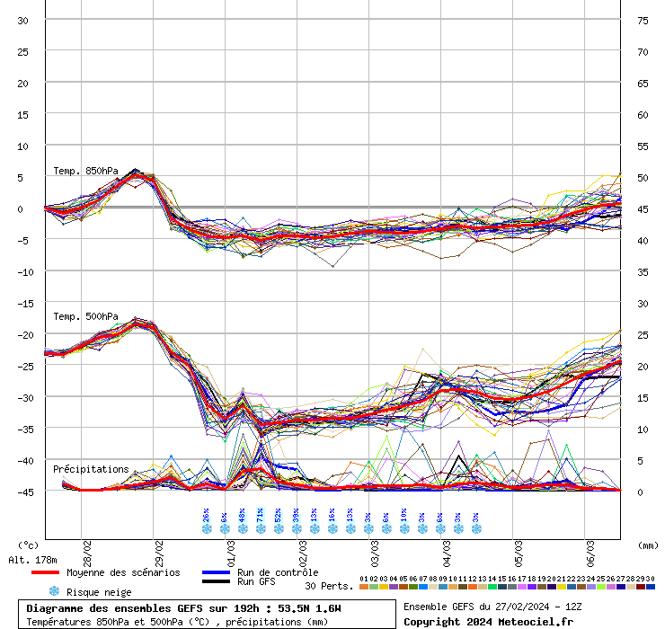
GFS ensembles now much firmer on cold spell locking in to mid month and beyond
This is all well and good this cold spell but there doesn’t seem to be much snow about in these models just cold and dry oh well least it’s better than wind and rain I guess
-
 3
3
-


Model Output Discussion - Into Winter
in Forecast Model Discussion
Posted
That’s hope the models up grade this cold spell just out on the mountain bike early ride light snow this morning Salisbury plain