


rory o gorman
-
Posts
215 -
Joined
-
Last visited
Content Type
Forums
Blogs
Gallery
Events
Learn About Weather and Meteorology
Community guides
Posts posted by rory o gorman
-
-
5 minutes ago, Moonbeem said:
What is a 528 DAM line -please excuse my ignorance
Simply put it's the thickness between the 500-1000 hpa layer, It's a strong indicator on the depth of cold in an airmass, generally under 528 is needed as a minimum, but the lower it gets the higher the probability of precip being snow.
-
 1
1
-
-
8 minutes ago, BIG LAD said:
was 3.5c when i got home from work at 6.30 so temps need to fall a good bit for snow to lay. can we expect any snow before midnight?
The all elusive 528 DAM line should be in over the north by about 00z. Precip should be of mostly of snow from there onward.
-
3
-
-
Just a quick undate ,
Looking over the latest data .There appears to be two main areas of interest in relation to organised snowfall. Firstly the running wave along southern counties should give some back edge snow as it clears given the depth of cold behind.The second feature is an embedded mid-level shortwave that moves across the country from north to south from above 4 to 8 pm . This should give good accumulations in many places. The only issue is how east the precip goes, that will be a nowcast as all models differ on placement. There is be also the standard sea effect snow showers running into the north and west most of the day.
-
7
-
-
Quite promising in the short term for the white stuff in many parts Thursday morning into the afternoon/evening 850's sub -8 country wide . Thickness <528 , DP's under zero. A number of subtle shortwaves moving down across the country. For a polar maritime airmass its as potent iv'e seen in years.
-
2
-
-
Bartlett /slug high develops again at 180hrs with a mobile westerly pattern resuming .
-
2
-
-
GFS trying to put the final nail in the coffin ? Shocker..
Although there are a wide range of solutions throughout the suite the op and control are very similar on how they model the greenland shortwave energy and 300mb flow. Of course a disengagement in the subtropical jet would lead to a much different outcome, but past experience would my give me little faith.
-
1 minute ago, SN0WM4N said:
It's almost like you know

Because the GFS low res will always revert back to zonal when the pattern is as erratic as shown. Expect a wide scatter on the suite later with the lack of upper air sampling this run is better off binned, there is obviously feedback within the algorithm regarding hemisphere pattern change.
-
2
-
-
1 minute ago, Carlrg said:
Easterlygate 2 anyone?
90% chance will end with a slug low and zonal . Searching for cold and reading what the models are actually depicting are different things..
-
1
-
-
We now have the room to develop a shortwave on wednesday .... Continues to trend west .
-
21 minutes ago, jgbgt said:
I count 5 members at 17/18th above the mean which still looks fairly cold to me. Bearing in mind the mean is screwed itself by the older solutions the probability is still for colder in my eyes.
Yes op and control are higher res, but from low res points both deviate from the mean quite drastically. (Pretty much the definition of an outlier)
jg
I don't really understand your point here? There is a clear shift in the ens pack to a broad number of outcomes. It doesn't mean that the chance of prolonged cold is finished , just that there are some plausible solutions which result in a mobile pattern being obtained. 24 hours ago it was as close to locked in as possible, in the timeframe with classic WAA to greenland and possible cross polar flow and rapidly deepening full-neg tilted trough pulling east . So this uncertainty is unfortunately classed as a downgrade.
-
1 minute ago, Kentish Snowman said:
You mean the ops are consistent? I believe Bluearmy has already stated that the parallel runs of both the ECM and GFS have trended colder than yesterday?
The GFS ensembles are not fantastic if it is cold weather you like but they are certainly not poor either with a number of perturbations keeping us in the freezer right out to the end of week two.
As for the ECM well we don't know where it sits within the ensembles yet although my money is on it being a mild outlier.
Anyway even if the doom mongers are correct and all everybody gets out of this upcoming spell is cold rain then so be it. It is only the weather after all!
Control backs the OP in both runs , but yes there are wild fluctuations some of which are backing prolonged cold . Taking some perspect almost all 21 members were depicting cold this time yesterday today is less than half . This is a downgrade as much as anyone may want to spin it. The rapid increase in the subtropical jet as a result of cut off heights is a credible solution that has been seen many times before. Just looking at this objectively and without bias.
-
2
-
-
9 minutes ago, Severe Siberian icy blast said:
I'm sorry but this place is so predictable. The very first words I look at is "this is a very depressing morning "
is it really ?
Firstly its only depressing if you allow yourself to be taken in by every signal model ,
secondl m what makes charts after t120 any more likely to be to come off than they showed yesterday , or the day before that ?
We still have a cold spell on , ok not freezing cold next week like everyone was hoping , still cold enough for snow , which is enough for me .
i didn't believe for one minute we would be basking in -10 850's , it's been a developing situation and it still is . The models will play around with different outcomes until they get it right , and they won't get it right until inside t72 with this type of scenario .
just enjoy the ride and don't get depressed every time the models change.
Very bias post I'm afraid. The gfs is consistent now in it's output , with the ECM backing the evolution this morning.
-
17 minutes ago, mountain shadow said:
And what about the boys and girls at NOAA? Do you think they'll be trumped by a pub run too?
You do realise they can change their output overnight , I have a number of friends that work in the NWS and they often follow the ECM raw output as it models the midwest and eastern board rather well.
-
1
-
-
3 minutes ago, Continental Climate said:
UKMO isn't a cut off Greenland high
The ukmo doesn't run out to 168 hrs you said all 3 models? , the gfs and ecm have no to toppler with almost full cross polar flow.
-
1 minute ago, Continental Climate said:
Yes if you look at all three charts in quick succession it seems it could be toppler territory at 168. Hope not though!!
How does one topple a cut off greenland high ?
-
3
-
-
2 minutes ago, PolarWarsaw said:
The low plays ball on this run...but as far as I can see, each run that gets closer to the time frame, waters the cold uppers out and delays them coming in.. the ECM last night and a couple of other runs in the last 48 hours had -7 uppers down over the centre of the spine of the country by Tuesday...then last night it's Wednesday...now it's Thursday and even then - they are modified.
Not to be negative, the runs are very good - but these small features shouldn't go un-noticed. Its another very good run. But as far as I can see the main trend for today so far seems to be;
- Delay of the proper cold getting in.
- Snow chances reduced for the south/centre of England
- Colder uppers being modfieid to make things more marginal..
ONE HUGE Tick for the 6z..
- The low plays ball (thank god).
Wrong.
If someone said to me... I'll give you a 3 day cold spell, with temps hovering just on the marginal bracket, but you will get 2 systems that produce 5cm and then 8cm of accumulating snow...or I get 10 days of ice days, that are sunny and frosty but don't bring snow to anyone bar coast fringes and Scotland then I would take the first one with my eyes closed, enjoy it and then search for another spell.
The greater majority of people want SNOW, not cold and frost.
You realise that the 'low' is entirely different from the one depicted in the 00z . This low forms as a result of falling heights and a 700mb vort lobe embedded within, known to many here as a 'trigger low' . Not related to the AZ trough on the 00z in any way.
-
1
-
-
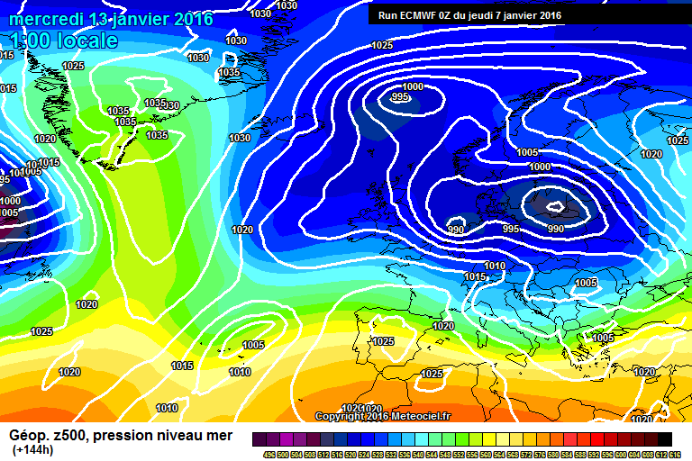
06z is far more in line with the ECM mean , Heights building back east and a much more pronounced gradient north of developing surface low.
-
7 minutes ago, Man With Beard said:
GFS 00Z ensembles are a bit more mixed than yesterday's
http://www.meteociel.fr/cartes_obs/gens_panel.php?modele=0&mode=1&ech=192
In particular, the Azores trough has blown up into an Atlantic low on quite a few runs, cutting off the cold feed for at least a time and taking milder air much further north.
Studying the different members shows even more clearly how the Atlantic low could be friend or foe. For the first one, scroll down the page quickly if you don't want to spill your breakfast:
The coldest ens members keep the Azores trough well to the south:
leading to this by T216
It's a 50/50 call this morning regarding a longer cold snap, according these ensembles
Basically what I was gearing up to write , Looking at it objectively there is still quite a spread in the GFS ENS regarding the ridge placement ,The development of the AZ trough my infact over amplify and result in a blow torch instead. This is far from a slam dunk and a non bias forecaster would would still air on the side of caution .
-
1
-
-
4 minutes ago, Captain Shortwave said:
Both the UKMO and ECM begin to bring the low near the Azores into play at day 6.
UKMO ECM
I must admit this is the first point so far where I am starting to feel a little nervous about this.
I agree a very west based ridge here, You can see the Met office's evolution to a westerly pattern clearly here.
-
14/21 ENS members go for a greenland / mid atlantic block , the slight concern exists with a trend to a more westerly based height increase which hampers deep cold arriving .
-
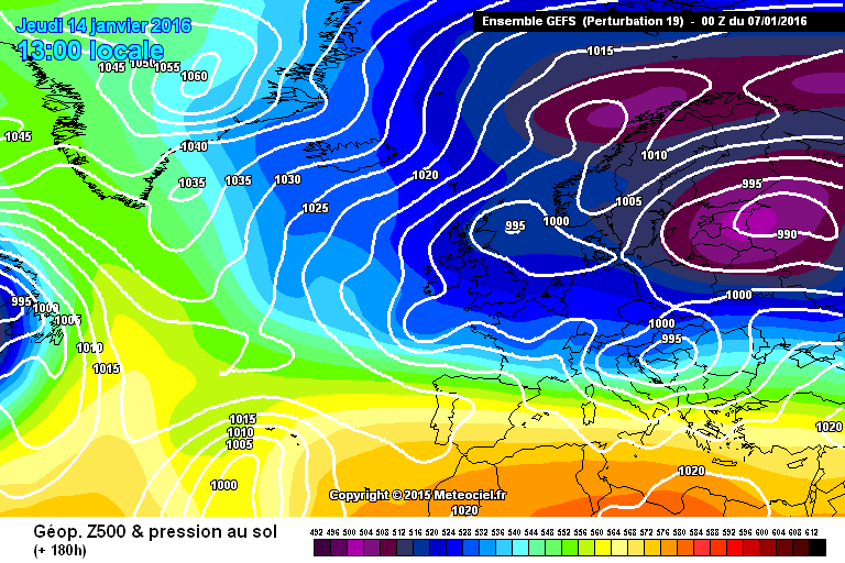
Gfs finishes with a nor'easter , London becomes New York ... Again all arbitrary after 180 hours on specifics .Upstream is at 09/10 levels.
-
2
-
-
4 minutes ago, snowangel32 said:
Yh could be an interesting Fi PV being attacked from all sides. Details still up for grabs. But it's safe to say we can lock in the cold for next week at least. After that anything is possible but we are in the game big time.
Yes , I would ignore the downstream modelling at this point as synoptically it's quite unlikely to be so slow given the amplification . This as a pattern is a very encouraging run for sustained cold.
-
1
-
-
Far better WAA to Greenland on this run. Trough appears to centred further west though resulting in slower timing of deep cold. I wouldn't overly read into this though, focus on upstream.
-
3
-
-
Given the SST'S current and the 500mb to 850mb temps, any 700 mb shortwaves ejecting south would be highly convective and provide quite a bit of snow even inland. Again the chance's of polar low development in the 12z output seems favorable . ECM is key , often seeing eastern seaboard amplification differently. Again we wait...
-
3
-


Ireland Regional Weather Discussion
in Regional
Posted
There is a slight warm sector in the low Hence the more widespread precip and higher DP's