


skatefan
-
Posts
37 -
Joined
-
Last visited
Content Type
Forums
Blogs
Gallery
Events
Learn About Weather and Meteorology
Community guides
Posts posted by skatefan
-
-
2 minutes ago, Bristle boy said:
It's only 2 days ago the NW 'big guns' were confidently predicting 2 weeks of severe cold; what's gone wrong? (So to speak). A silence has descended today, on the forum, from NW's most respected posters. Stunned?
Too fast retrogression of the HP creates a level playing field for the LP's. Impossible to say what will happen but the charts don't promiss much!
-
3 minutes ago, CK1981 said:
Yes, you could be right there, I’m just trying to keep positive. A west based -NAO will nail it for us ?
Always good to keep positive! But a westbased -NAO is almost bound to happen as I see it.
-
4 minutes ago, CK1981 said:
Cast your minds back to the first SSW. The models were in chaos dealing with the outcome. Many favoured a mild solution, but they were wrong, and at a short time frame.
Since then, we’ve had a secondary warming. The models will now be in the same position and trying to work out the solution (but with the additional chaos following the first warming)
I firmly believe they will correct to a colder solution, as before.
I don't believe that, how much I would like to: the SSW and secondary warming determined the positioning of the HP's: and that gives too much retrogrssion and a free game for the LP's.
-
6 minutes ago, ICE COLD said:
Keeps the the low a lot less intense ? Is that right ? Or am I talking ??
I would love to have this but Navgem over-estimates the HP above Greenland. ECM, UKMO and GFS don't see this.....
-
 1
1
-
-
3 minutes ago, Mike Poole said:
GEFS ensemble mean at T144 might just calm the nerves:

Still think this will go further south, we'll see!
Nope! The HP above Greenland retrogresses too fast and LP's coming in from the SW will create a big mess of changing conditions, merely S to SE driven..
Although the ECM12 was at the end clearly a warm outlyer, it presents the trend in the models. After next weekend it is clearly gone with the cold.
-
 1
1
-
-
3 minutes ago, Purga said:
Any good folks?
What do you mean?????
-
12 minutes ago, AmershamMike said:
The real Stormzy!!!
And more! Great to have someone aboard this thread who can take some distance and describe the beauty!!!!
-
3 minutes ago, jethro said:
An ode....
The charts they have shown from long, long away
That the SSW would hold immense sway
Some urged caution, some said doubt
They said 'la la la, we're not listening, our faith is devout'.
Their ideas they have shown with chart after chart
Their belief, their knowledge, it came from the heart
I always reckon, credit where credit's due
So take it from me, an enormous 'thank you'
I can't read the charts, they're blob after blob
I rely on you all doing a fantastic job
So the beasterly's coming, inching closer each day
The temperature's dropping, the rain's gone away
What wonders await? Well no one can say
But I do know one thing, I'm polishing my sleigh
Pondering starts, what can it be
Surely it means '91, maybe '63?
With charts such as these, manna from heaven
Sure can mean just one thing, another'47
The cold, it's a coming, we all know that
Wrap up warm folks and remember your hat
Will we get an inversion or plenty of snow?
Or that mythical beast, a channel low?
Our dreams they've been busted many times in the past
The cold came and it went, it just didn't last
This time it is different, our boffins of gold
Foresaw and predicted and then we were told
Look up to the sky, high over the cloud
Stratosphere it said 'yes' and it said it loud
So when it comes, go out to play
Sure check the charts but then step away
Synoptics like these, well we know that they're rare
Ski, skate, slip and slide, sledge without care
Dear Mods I may be a tad off topic
But charts such as these, by god, they're epic
Please forgive me I beg, the rule, I don't mock it
But such weather porn made this lass poetic
Epic poetry to an epic development.........
-
2
-
2
-
-
Well, the first week cold will be there, whether or not delayed by a day or so!
Then we go to FI-watching: will the Greenland high hold itself and tilt clockwise due to the energie on the Asian side or will there be a new pressure-rise from the south? Both scenarios open the door for a new invasion of cold.
Obviously there are numerous other scenarios but i like to look at it from the cold side......
-
3 hours ago, chionomaniac said:
I'm here - been working and have also had to pick myself off the floor after checking the 12Z.
Best ever trop response that we have been able to track following a SSW, oh those of little faith lol.
I did think of buying all the snow shovels and salt in B&Q yesterday and then selling it back to them next weekend....
I have been convinced of an epic cold spell for a long time now (since before the split but my resolute belief was reinforced when I saw the residual Hudson Bay daughter vortex getting taken down).
It may have taken the best part of 10 years but finally we are seeing the makings of an epic spell when you take the strat vortex out of the equation. Even @TEITS may finally have to concede that there is something in this teleconnections Malarkey!
I want to pay my respects to Chionomaniac, who has tried so long to bring the effects of a SSW on the tropospheric conditions to attention!
We are currently seeing what that means! CHIO gave the first signals on the stratosphere thread and: Yes, we are seeing an incredible SSW and we are seeing incredible tropospherical response. Let us remember how long it took for the models to take a grasp on this and, certainly with this kind of events, Keep the eyes on the large-scale movements when SSW events occur and a lot off uncertainty from models wil take a place!
-
7
-
1
-
-
12 hours ago, Glacier Point said:
So far, text book.
First tropospheric response will not be the last. Second and third waves, the latter with the most pronounced impact in the AO still likely, these timed around mid to final third March into early April.
The MJO wave from January and February left a footprint in the Equatorial Pacific.
Don't think this was oceanic Kelvin wave given its timing and duration.
Yeah textbook. Currently the second wave is happening:
but where will this lead us? It looks like this SSW is slowly moving into the final warming? I have never seen this before.
-
1
-
-
Don't forget that the second blow on the remnants of the split strat. vortex is currently taking place. Anything beyound T144 is therefore soo uncertain!
It will take some time again before the models get a hold on this...... but that is what makes model-watching great!
-
3 minutes ago, Quicksilver1989 said:
A glance through the 18z ensembles at T102 suggests that support is increasing rapidly for the development of an intense Scandi high. Phase 1 of getting things set up to our NE looks like its going to succeed.
Next step is to not avoid any awkward shortwaves forming in the cold air to our east like a few other members have mentioned. That stopped the core of the cold air in February 2012 hitting our shores. However with an Azores low instead of a high this time we have less to worry about.
Still cautious but belief is increasing this may come off.
Being born in the late 80's I cannot remember a truly cold easterly hitting us. That has to be the best run of the internet era.Fantastic runs today!
I don't believe, as I argued earlier, that shortwaves will change the large-scale synoptics caused by the SSW:
- Ridging N/NE of the UK and HP across the pole
- PV energy slowly transferred to the Pacific side
What you see today is that when the models grasp the large-scale developments without to much disturbances from small to medium scale waves, the crossmodel agreement becomes clear.
Obviously, shortwaves can have a big effect on local development in cold and snow but the big picture is quite clear now....
-
2
-
-
As I tried to point out yesterday: the developments are dominated by the largescale movements due to the SSW: as a consequence of the revearsal in the Stratosphere the tropospherical vortex-energie above Canada/Geenland is bound to move to the Pacific side.
It is strange to see that most models see this in the longe range but fail to incorporate it in the short-range. It is still my opinion/question that this is because hi-res models are mislead by shortwave activity!
The positioning of the HP across Europe is an example of this: it will occur because of the large scale dynamics, the only question is: where will it land.
-
2
-
-
Maybe this has been discussed on this forum before, I don't know. But I was pondering about the role of shortwaves in the models in situations of large-scale stratospheric changes like the SSW we have at this moment. In my meteorology-classes I have learned that this kind of changes generally are dominated and driven by longwave activity/movement and that shortwaves are a consequence of those large-scale movements.
The essence of my "pondering": could it be that the high-res parts of the NWP models (specifically the OP's) in these situations inherently over-estimate the effect of short-waves and could lead to short-term fluctuations? I think that is what we are watching continiously!
As a consequence you could say that in these situations relatively low-res (ensembles, means and low-res models) is essentially better because it keeps focus on the large-scale development?
-
1
-
-
8 minutes ago, CreweCold said:
That's GFS low res for you...no way that low behaves like that if that was being modelled within hi-res. All academic anyway as it's the trending we're interested in at those timeframes.
Yes. It was interesting to see how GFS low-res played with the Greenland-scenario. We'll have to wait and see whether this develops in a FI-trend...
-
1 minute ago, blizzard81 said:
I am now lol. Just seen the day 10 chart
T240 reaching out for Greenland.......
-
1
-
-
20 minutes ago, Nick F said:
This time round the atmospheric drivers for change are a lot more favourable, namely the MJO coherently moving into colder phase 7/8, the best MJO propagation we've seen this winter, with enough amplification to induce HLBs rather than MLBs. The MJO forcing concurrent with planetary wave number 2 over Scandi/Svalbard propagating up from the trop will mean the stratosphere PV will be in an increasingly weakened state as we head through early Feb too. Could go wrong if the HLB doesn't position right, but more background support this time.
Yes, and you can see that very consistently in the modelled position of the Scandi-H: it systematically tends to be placed much higher, even elongated. Wether that is good or not remains to be seen but it is a big difference with the december situation! Back then it was always the question: will it be MLB or HLB.
-
1
-
-
It seems to me that in most models a slight HP zone above Greenland steers the energie more southward and thus creates a delicate balance between the heavy atlantic and HP above the continent. I can imagine that a small difference in the upstream modelling will create a large difference in the downstream battle...
-
1
-
-
25 minutes ago, blizzard81 said:
I can't believe more people are not seeing the trends today. The lovely negative tilt to the "attempted" Atlantic assault coupled with the ridging into north west scandi. I would advise some on here to look at the charts from yesterday at the 6 to 7 day timeframe and compare them to today's 5 to 6. You will see what I mean. Remember those long draw south westerlies the models were showing in the medium range 48 to 72 hours ago? Where are they now? Get my drift?
Yep, saw that too. The big 3 are also fairly agreeing on this (T144) although ECM has, again, the most N movement.
-
1
-
-
1 hour ago, More Snow said:
Well been here since October looking at charts and run after run after run looking for Snow and cold. im drained ive no energy left to keep looking into the future. the only thing stopping me from saying see ya next winter is the possible SSW.. if it doesnt show up by the end of Jan then im calling an end to winter 2016/17.. so much promise at the start.. the pv looked totally battered early doors and we all was very excited because we all thought that HLB was going to kick in and send us into a winter wonder land. didnt happen then we all went into overdrive with the mega cold that the charts showed for early Jan.. didnt happen. yes some of us saw snow for about an hour or 2 at best and then here we find ourselves at the back end of Jan and still nothing to make us want to get excited...give it 2 weeks and we will all be saying plenty of time left still 4 weeks etc etc.. but i just dont see it. i dont see any cold snowy spell coming up before the end of Feb.. even if we get a SSW it does not always mean cold and snow..
Models are what they are: models! They take into account what their creators know about the atmospherical processes and that is a lot. But there is also a lot they don't know or are unable to bring into the models. There is a lot of uncertainty, exponentially increasing after D1. When you can't stand this uncertainty don't look at models!
-
8
-
-
41 minutes ago, damianslaw said:
ECM did very well picking up the blocking theme holding back the atlantic this week, with GFS having none of it, but then showing the atlantic retreating, but ECM got it wrong with the northward extension of heights, instead they've ended up just to our SE. With little changing the overall pattern of recent weeks, no major forcings taking place to cause a sudden shift in things, I fully expect the ECM to continue to suggest scandi heights 7/8 day timeframe over coming runs. GFS show varying degrees of zonality sometimes with a major easterly push, sometimes holding back as the current GFS 18Z is showing, but the end result central core heights of the block being both sufficiently close to our shores to kick aside any significant zonal mobile westerly and also any cold continental air penetrating our way. So expect more of what we have had all winter so far for a bit more time yet... Feb holds chance of significant shift in things though, which way who knows...
An excellent wrap-up of developments i think. But it still strikes me as strange that ECM and GFS model so differently in a situation where there are, as you say, few major forcings taking place. In a relative quiet environment every model should be down to basic airo-, thermo- and other dynamic models..?
-
1
-
-
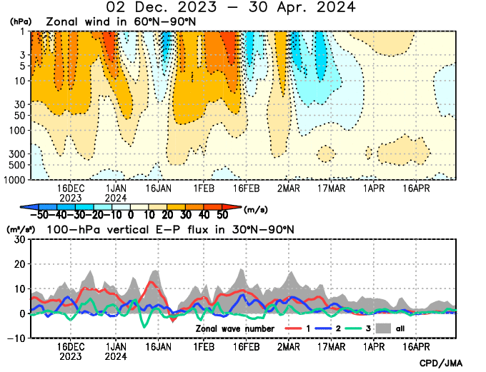
Quite a dramatic final warming of the stratosphere this year shown nicely when looking at the temperature and wind anomalies for the end of March.
temps...
time_pres_TEMP_ANOM_JFM_NH_2015.gif wind...time_pres_UGRD_ANOM_JFM_NH_2015.gifJust look at that rise in temperature at 30 mb over the pole!
It seems indeed quite dramatic. Remnants of the polar vortex are driven far into Russia and appear to reluctantly give way. A late Spring seems to be occuring. Symptomatically for this winter: a not too strong Vortex that is stronger than it appears...?
-
Hmm, awfully quiet over here.
I might be completely wrong but is there a reversal in the making?
Temps at 30 hPa are rocketing up like early Januari. At 10hPa less pronounced though.
I can imagine that these observations are illustrating the shift of the strat-vortex away from the pole?
-
3
-


Stratosphere and Polar Vortex Watch
in Spring Weather Discussion
Posted
As far as I can see this historic SSW is in fact (slowly migrating into) the final warming. I don't see any significant restoration happening coming weeks.
The stratospherical reverse flow has dropped but is still very neutral. I am asking myself what this dynamically quiet context will mean for the coming weeks and spring. Lingering LP's and shallow HP's don't sound good to me, and don't produce much trop-strat effects.
Do we have comparing years?