


thesnowman
-
Posts
20 -
Joined
-
Last visited
Content Type
Forums
Blogs
Gallery
Events
Learn About Weather and Meteorology
Community guides
Posts posted by thesnowman
-
-
check out 50 miles east of paris -! mega storm
-
... no snow for 2 weeks based on charts... winter is over for ireland now.... what winter? had one flurry! well done to carryduff chap , apart from carryduff no snow in ireland in winter 2012 /2013
see you all next December for
-
Yeah Glengormley has been hit with a huge snow stick last night and this morning!!!!
Baltic, I hope your little girl is ok!!!!
pictures please - none here - but pictures - I need evidence - please please
-
, u not get 6 inches last night>No fair, i never get snow up here.
;-()
-
.. What a MASSIVE DOWNGRADE from GFS - could this be the biggest reversal of the winter! and within reliable timeframes - within 36 hours - cold shunted to EAST with Zonal pattern established by Wendnesday... why did no expects pick this up?!? a cracking change by GFS model
we wait on for real cold
-
NO SNOW for Western Fringes on any chart - rain for Western Scotland, Northern Ireland and West WALES and S West areas. Only a 2 hundred mile shift to EAST would wipe out snow potential for everyone else - so care is required !! wet snow for most - with sleet at times
-
GFS backdown appears to have missed quite a few on the thread today...... diluted by 35% from 00Z charts.... upgrade possible but not likely I fear
-
Yes - I really have no idea why posts asking for caution are being shot down. GFS is showing another highly possible scenario, it's almost as though people have forgotten it exists! With the failed December easterly it was GFS that reacted first.
I have to laugh and agree - the MODEL of greatest respect is GFS - the daddy bear of all models - BUT when Daddy scolds us - everyone runs to Mummy bear and baby bears because they make us feel warm and cosy... deep down we all know who is boss! so GFS return to Zonal - a 4 day cool blip - thats the facts as they stand, and don't be thinking daddy bear GFS will be changing his mind at 10pm tonight!
lets see if daddy bear is consistent... he has been in the past
-
.. 50%/75% downgrade on GFS this morning - the reluctance to develop and easterly worth anything is quite startling - if anything the re establishment of high pressure to the West of Iberia looks more likely now - and what does this mean - MILD and WET, all likely it appear around days 5 to 7.
What a miserable outlook in the medium term. Longterm - to be ignored - bases on winter so far...
-
If I see one more one-liner "but we should remain cautious" post!!!??!!
Stick it in your signatures if you are that way of thinking, it's getting very boring!
Edit: Ah, I see Chiono beat me to it!

... still everything to play for past 96 hours... however zonal is the norm ! I'd say 75% we will revert back to Zonal once this HP has drifted SE and faded... 60 years experience I'm afraid - thats a lot of winters.. sorry to put a damper on everyones optimism, cooler because " its mid winter" and its been so so mild !
-
I'd love to know the stats so far on this winter... for me mild and wet, about 3 days of frost in October, no snow within 500 miles, and the date 4th January!!
Surely it is it the least snowiest winter EVER! I'd love to know if this is the case or is it just a perception
-
- Why are people guessing at the result of the SSW when no one knows the result for us? - NOT EVEN THE MET OFFICE EXPERTS KNOW!!
- Why do we need to be told that it won't be good for us, When no one Knows? - AGREE
- Why is the GFS wrong and ECM right, when no one knows? - WHEN PEOPLE LIKE HOW IT LOOKS
- To (TOO) many people want to make a judgement in the hope that they can say told you so. -THIS SITE IS FULL OF KNOW IT ALLS - only a few are sensible TEITS as an example
- There is more chance of cold now than there has been due to various indicators, so lets see how it pans out. I think everyone knows we may miss out but..... - THIS HAPPENS AS WE APPROACH MID WINTER
- Lets see where we go from here and learn as we go. - WHAT WILL BE WILL BE
at last.. a nice locally and unbiased view
- Why are people guessing at the result of the SSW when no one knows the result for us? - NOT EVEN THE MET OFFICE EXPERTS KNOW!!
-
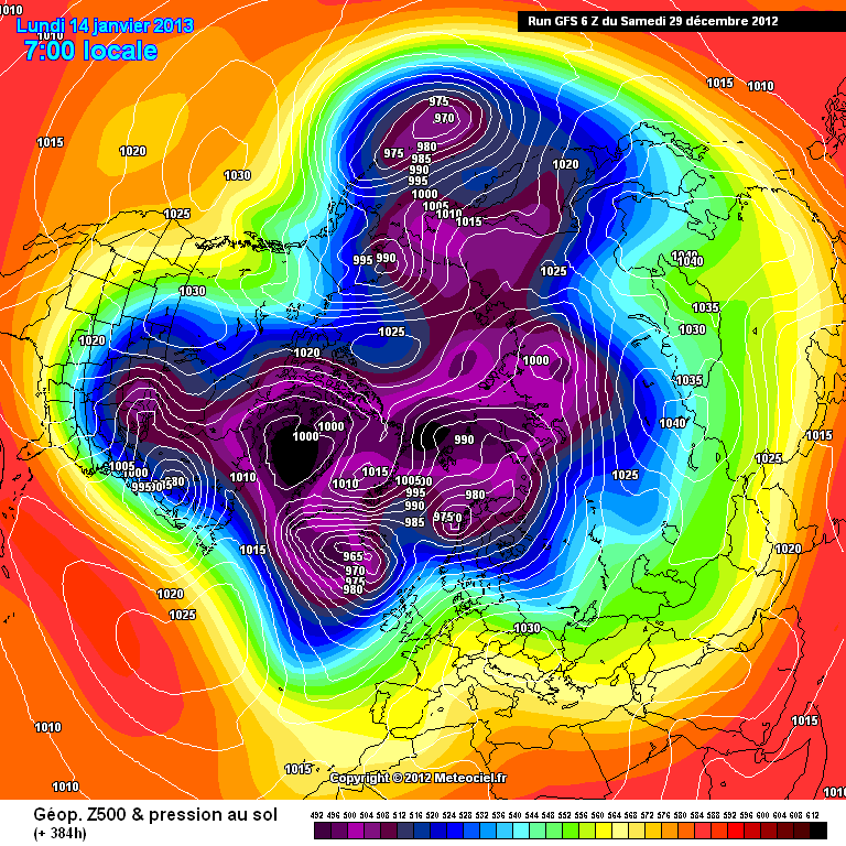
As +384 now takes us to mid Jan i've been hoping for some potential to be shown on the GFS runs.
http://modeles.meteo...snh-0-384.png?6
Unfortunately that isn't the case on the 06Z with more of the same i.e No N blocking, Strongly positive NAO
You evaluation is spot on TEITS, we are definitely now looking out beyond Mid January for anything remotely cold,
My concern is that with lengthening daylight hours, and the total LACK of cold in WESTERN EUROPE, the continent will not now hold onto deep cold if it arrives, the outlook is extremely bleak for anything cold in the winter 2012/2013
-
...What incredibly poor COLD charts all round this morning....... If anything they are getting"worse" if COLD is what we are looking for. 90% of the ensembles are indicating > 0C for next 2 weeks - thats awful for mid winter. Kids will grow up this winter not knowing what snow is.. Anyone fancy RAIN?
-
I would say only 6 weeks of winter left because the 06Z is dreadful until mid Jan.
Quickly losing faith in LRF's. All the talk of negative AO/NAO/Greenland HP and for the rest of the year into Jan we have the exact opposite!
At the moment the ECM seasonal output looks to be the only correct forecast which did indeed predict a mild, zonal Jan.
Fully agree TEITS... another spot on post...well done.... probably only 4 weeks of winter -these patterns last a long time, and we have only just got into this zonal rut, lack of snow is pretty remarkable so far this winter.. could we have a "snow free winter" look 75% likely looking at these runs
-
Everyone - must tell you this!! ( please don't delete)
.. Got up ... opened the curtains.. and guess what........ WHITE EVERYWHERE !!!!..........
Yes yes......... the wife covered our bedroom window in ARTIFICIAL SNOW from the outside....................... what a cool present on Xmas morning -
thankyou darling,,,XXX... thanks for nothing models (GFS etc bad humbug)
-
TEITS is spot on again over recent days - well done, very little out there to give us any confidence in cold or even "cool" over the next 2 weeks. This is probably as bad as it gets ( or has been) in recent years. Such a promising outlook from our friends in the Met - however nothing as we approach mid way through winter

Ireland Regional Weather Discussion
in Ireland Weather Discussion
Posted
Fine snow grains in Downpatrick and getting heavier with sky a lot darker ! hopefully 24 hours streamers on the way for us!