


CWT2012
-
Posts
261 -
Joined
-
Last visited
Content Type
Forums
Blogs
Gallery
Events
Learn About Weather and Meteorology
Community guides
Posts posted by CWT2012
-
-
Mixed feelings about that channel low
If it hits us then there could well be record breaking snow for the time of year but if it sinks south and misses us we are kept in the freezer for longer and more chance of reloads from the north and east
12"+ on Tuesday or a few more snow events, hard choice
-
If the GFS comes off an area from Brighton to Devon from the coast to about 20 miles inland could get upwards of 2ft of snow IMHO
People living particularly in Dorset, Somerset and Devon should be very excited right now
-
Definitely downgrades from the ECM and GFS but it is just one set of runs, no point taking them as gospel after run after run showing bitter cold and heavy snow, if the 12z and 18z are showing similar i will start to get a bit concerned but until then the 6z is going in the bin
-
You know snow is on the way when the server crashes under sheer volume of users
-
No it would not. Are you Yamkin reinvented ?
It could result in considerably snowfalls across Eastern and Southern England.
The chart mountain shadow posted showed a Thames streamer with the shower train stretching all the way back to Holland/Germany, with the uppers forecast I can see astonishing depths, dare I say it, equalling or even topping Feb 09
-
Wow just wow, am in shock
Hope there are enough soldiers not in Afghanistan after all these cuts as they may well be needed monday
Charts of the winter no exaggeration
-
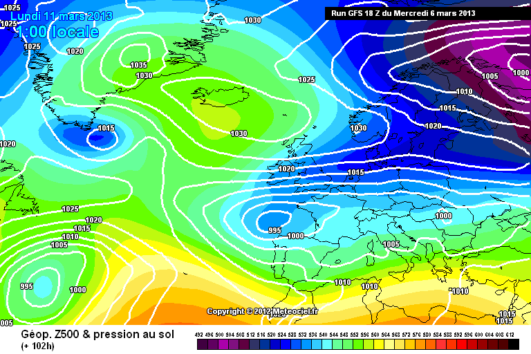
http://modeles.meteociel.fr/modeles/gfs/runs/2013030618/gfs-0-102.png?18
Chart of the winter / Spring for me & for most of England!
http://www.wetterzentrale.de/pics/Rmgfs1082.gif -13/-14c uppers, perfect flow allignment, -5c dewpoints, 20c gradient & sub 528 heights.
Perfect for heavy convective snowfall across england.
S
Agree Steve, drooling over that one, that would result in over a foot of snow across much of mainland Britain
Truly epic stuff
-
Thames streamer and a half..
http://cdn.nwstatic.co.uk/gfsimages/gfs.20130306/18/96/ukprec.png
Wouldn't think much of my chances of getting to work on Monday morning in some eastern and south eastern parts.
The army would be on standby if that chart verifies
Chart of the winter
-
Deep cold with heavy snowfall looks nailed on now, it is just a question of timing, amounts and length of the severe spell
-
GFS has been onions all winter and finally delivers the goods in style, roll on next week
-
Good times ahead, looks like potentially record snowfall for March if particularly the GFS verifies, 12-18" of snow quite widespread in eastern parts with the strength of those winds and those uppers.
Things can still go pear shaped but the 6z is definitely a massive upgrade which could paralyse eastern Britain
-
Surely the UKMO will admit they are wrong and fall into line with the ECM and GFS
-
I would bank that ECM chart, heavy deep snowfall and prolonged severe cold
With E/NE and those uppers has to be a chance of a Thames streamer too surely
-
Slightly off topic but what has happened to Ian Ferguson? i miss his updates on what Exeter are thinking
-
Think we can bin the UKMO
GFS has been consistent throughout in its forecasting of this potential snap but UKMO have been flip flopping and dithering
GFS it is
-
I suspect you are being a touch OTT re things being nailed on especially with regard to how much falls out of the skies. Predicting amounts this far ahead has about a 5% reliability on both summer and winter statistics I'm afraid.
I didn't make any depth predictions
 been stung there before, what i meant is for the time of year, with the strength of the sun it is almost impossible for snow that falls one day in March to still be around 24 hours later whereas with the uppers here any snow that falls would stick around so i meant special for time of year
 -
The only certainties are that it is going to be very cold (nailed on) and that areas particularly to the east are going to see very heavy snow showers (nailed on), it is all about the finer details now, length of the cold snowy snap and the intensity of the snow, all 3 of the big guns support the extremely cold and snowy weather but are just not agreed on timing and length of the spell and its severity.
But we are on the brink of something quite special for March
-
Think the ECM and UKMO can be binned
ECM is all over the place, it is simply throwing several balls into the air and hoping one lands, hasn't got a clue what it wants
UKMO goes against what the Met are saying, the Met seems to be siding with the GFS (snow in eastern parts)
-
You know we are desperate for snow when we are straw clutching with regards a model that has been quite frankly hopeless this winter.
It has to get something right sometime so lets hope it is this
-
Please define record levels of snow for the time of year CWT, agree Ecm certainly seems keen for a return to winter though.
Someone posted a history the other night that showed the record for the SE in March/April was13cm in 2006, if and its a big if the ecm verifies as it is now it would be a surprise if that total was not exceeded .
ECM has a habit of FI eye candy and nothing coming lf it so am not excited at this stage but if it is right for once in FI would be surprised if 2006 isn't exceeded
-
Record levels of snow for the time of year if the latest ECM came off, but with 9 or 10 days to go I expect downgrades
-
No point getting excited about stuff showing in FI, can't remember the last extreme FI solution that was actually right, this starts showing at 96 instead of 240 i will start getting excited but until then its meaningless eye candy
-
Hmmmmmm, Quite in here, In fact all over really. I wont let on where the next bit comes from as you will probably guess. Nice thought though.
Cold end to winter + winter set to continue into spring + snow risk dates
The end of the meteorological winter (end of February) and into the start of spring (start of March) is likely to see a continuation of winter conditions in terms of cold and snow episodes for the UK. It will also be particularly dry for this part of the forecasting period, but not in terms of precipitation as snowfall. There is also a risk that some major snow events will develop throughout this part of the forecasting period, but especially more so throughout the period of the 1st - 7th March.
This may then be preceded by a brief period of milder temperatures and wetter weather, especially across the southern half of the country. However, it is then likely to turn exceptionally cold for the time of the year once again. This is likely to lead to the development of some quite severe frosts and further snow events for a large portion of the remainder of the month, but especially more so throughout the period of the 16th - 24th March. There will also be some very strong winds at times, heightening the risk of some developing blizzards under the right conditions. It is therefore, plausible that March could turn out to be one of the snowiest that we have experienced for quite some time. There may also be the potential risk of it becoming one of the snowiest March periods on record, and it will be exceptionally cold at times too. However, one or two periods of brief moderation and milder temperatures still can't be ruled out throughout the start and later part of this forecasting period.
Have you guessed.?
Oh Happy Birthday Net weather.
Piers Corbyn?
-
In my opinion, Spring will be very late this year and winter will last longer
I only want an extended winter if there is going to be heavy lying snow, if not i want to get in my shorts and enjoy some heat and beer gardens
I don't think it is likely now this winter that there will be any more lying snow in March that lasts over 24 hrs, the strength of the sun will melt it quickly so for that reason I can't get too excited
 been stung there before, what i meant is for the time of year, with the strength of the sun it is almost impossible for snow that falls one day in March to still be around 24 hours later whereas with the uppers here any snow that falls would stick around so i meant special for time of year
South East and East Anglia Regional Discussion 12th March 2013
in Regional
Posted
Total non event here yesterday, a few heavy bursts of dandruff blowing in the wind but little to get excited about.
After Kent and Sussex stole all the snow our area deserves a pasting before the heat comes