


Gordon Webb
-
Posts
1,708 -
Joined
-
Last visited
Content Type
Forums
Blogs
Gallery
Events
Learn About Weather and Meteorology
Community guides
Posts posted by Gordon Webb
-
-
30 minutes ago, cheese said:
This is what the 06z UKV was showing, it's a pretty big shift south. Disappointing considering we never get really good thunderstorms here.

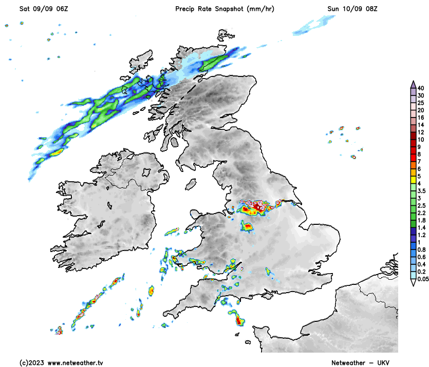
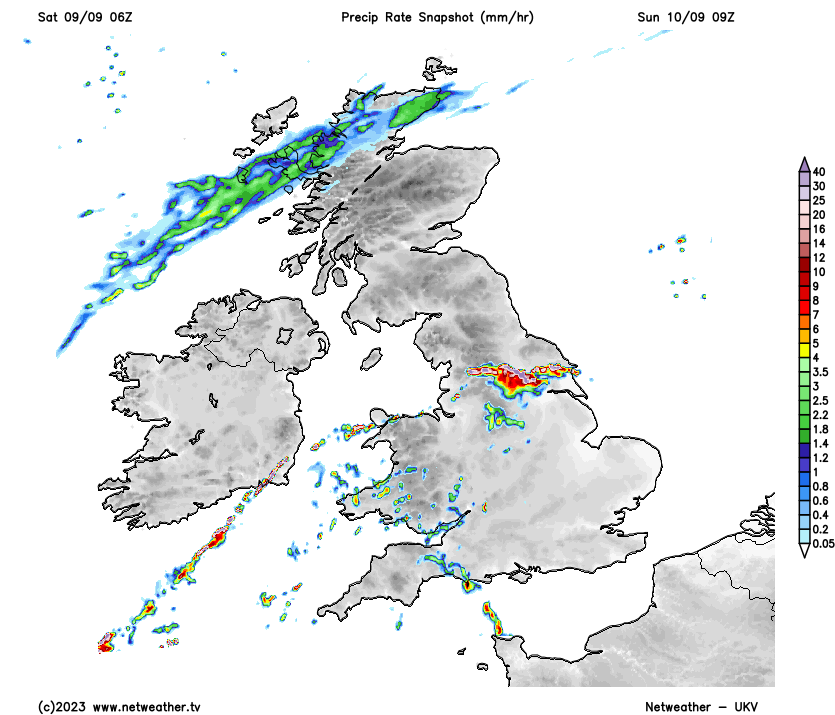
your times look wrong 8 and 9 am , that might be the elevated stuff from overnight that may or may not occur , it is another batch that is expected to develop for more n areas in the Afternoon
-
26 minutes ago, minus10 said:
Well that is significantly further south than the mo warning area...just need to nudge it bit further sse on future runs ....
not so convinced that is so further south , it's for a hour earlier than the met warning , the met also having it moving north and runs this close out should be treated with caution IMO
-
1 hour ago, multi cellular thunderstorm said:
Pleased to see this new Met Office warning for tomorrow.
70mm in a few hours for "unlucky" locations? I'd change that to lucky!
Looking forward to getting out chasing tomorrow.
unusually for the met office these warnings for today and tomorrow actually ties in what is expected
-
12 minutes ago, WheresTheSnow said:
34c has been mooted but I'd be surprised if it occured , if anywhere has a chance it'll be East Anglia / SE England as they are the only places expected to be or at least forecasted to be dry hot and sunny tomorrow with a lot more cloud and rain/showers/storms elsewhere
-
 1
1
-
-
hello
just an enquiry
Convective Weather has been quiet for weeks , just wondering if anything has happened ?
-
38 minutes ago, mb018538 said:
ARPEGE is showing a wide area of 34-35c on Sunday.....which looks incredibly optimistic. I think something closer to 33c in one or two spots, but an area that wide seeing above 34c just isn't going to happen.it should be pointed out this is mainly E Midlands Eastwards & SE England and nowhere else
-
1
-
-
52 minutes ago, Captain Shortwave said:
No secondary warm up likely now as the jet stream strengthens and slowly heads south during the weekend. Saturday looks decent for most but only the south hanging on to fine and very warm conditions on Sunday.
It looks like a weak cold front will become slow moving over northern parts, though rainfall is probably going to be limited.
Before then, Wednesday/Thursday still look good to hit 90F in places.
Arpege going for 33c on both days, Thursday the hottest conditions look more widespread.
just as well with people back at work after hols and kids back at school and the shorter days , weather like this now is rather academic except possibly for the die-hards
-
best to make the most of it
forecasts suggest it'll be less sunny and a lot colder in about 4.5 billion years
-
4
-
 1
1
-
-
14 minutes ago, Alderc said:
No worse than walking the dog in jumpers, waterproofs and through muddy paths in summer. Still don’t understand however people have such a low tolerance of even moderately warm conditions that only for a month or two at most.
why would you put jumpers and waterproofs on the dog in the first place ?
i mean I understand the dog walking through the muddy paths
-
5
-
-
well for me today is 2 seconds shorter than yesterday and to take from game of thrones - WINTER IS COMING
-
6
-
-
4 minutes ago, Scorcher said:
No doubt a breakdown is coming but I'm hoping (as many others are I'm sure) that we can at least eke out another very warm/hot day on Sunday rather than the heat being swept away overnight.
wouldn't bother me if it wasn't
-
Day 1 Convective Outlook
VALID 06:00 UTC Mon 19 Jun 2023 - 05:59 UTC Tue 20 Jun 2023
ISSUED 06:25 UTC Mon 19 Jun 2023
ISSUED BY: Dan
Heavy rainfall over Scotland on Monday morning, associated with a pronounced shortwave, will gradually clear northwards trough the day - although there is scope for embedded elevated convection in eastern Scotland, feeding inland from the North Sea. Elsewhere, a bright and breezy day is anticipated underneath a weak, transient upper ridge. That said, diurnal heating will yield 500-900 J/kg MLCAPE over Ireland/Northern Ireland beneath the eastern flank of a cold pool aloft associated with the broad upper low/trough to the west over the Atlantic. As such, scattered showers and a few thunderstorms are likely here, especially during the afternoon and early evening hours. Showers/storms may become particularly focussed along a couple of marked SW-NE convergence zones, especially from Munster to mid-Leinster and perhaps another from Connacht into Ulster. Modest southwest flow aloft with a unidirectional wind profile will result in 15-20kts effective shear, allowing some cells to become somewhat organised and capable of producing hail potentially 1.0-1.5cm in diameter (sub-severe). The risk of flooding will be augmented by stronger steering flow than recent days, however showers running along any marked CZ may tend to train over similar areas, resulting in locally large rainfall totals. A few showers/thunderstorms may also develop in parts of Scotland during the afternoon and early evening hours as well.
For England and Wales, while diurnal heating will lead to increasing instability, forecast profiles reveal substantial subsidence aloft and mid-level capping. It is still plausible a few heavy showers may develop, especially from north Wales and across northern England where a tongue of higher surface dewpoints may exist, although a few odd showers may be possible elsewhere - perhaps also from south Wales and across the Midlands to Lincolnshire. One or two cells may produce a few lightning strikes, but the risk overall is higher in Ireland. If any convection is able to punch higher than the mid-level capping then it may benefit from substantially stronger directional shear given the presence of a jet streak aloft.
While showers/storms will tend to decay during the mid-late evening hours, attention then turns to northern France as a shortwave rounding the base of the main upper trough to the west of Biscay engages with the western flank of a relatively high Theta-W airmass over France. The net result is a developing area of showery rain with embedded elevated thunderstorms over the Bay of Biscay during the afternoon hours, moving across the Brest peninsular through the evening hours, this then likely to grow upscale into an area of heavy rainfall across the English Channel and then moving into SW/Cen S England overnight. Exactly how much lightning activity occurs with this feature is uncertain, but there may still be pockets of activity embedded within the broader precipitation shield (perhaps most likely on the eastern flank of precipitation with unimpeded inflow). Additional, more localised elevated showers/thunderstorms will be possible further east along the south coast. The main threat will be the risk of locally high rainfall totals in some southern coastal counties of England, and perhaps also the Channel Islands.
-
6
-
 2
2
-
-
9 hours ago, Bats32 said:
If you're in the SE then yes, us in the NW not so much.
well you know how it is , some forget that the UK goes beyond the SE
-
1
-
-
updated
Day 1 Convective Outlook
VALID 06:00 UTC Sun 18 Jun 2023 - 05:59 UTC Mon 19 Jun 2023
ISSUED 06:44 UTC Sun 18 Jun 2023
ISSUED BY: Dan
A broad upper low will remain to the west of Ireland on Sunday, with a relatively high Theta-W airmass (>16C at 850hPa) covering much of the British Isles. A shortwave trough migrating northwards on the eastern flank of the upper low may provide the focus for scattered elevated showers or thunderstorms across parts of northern and eastern England on Sunday morning, the focus then shifting to W/SW Scotland by the afternoon. In its wake, a humid airmass persists (dewpoints 17-19C) which, coupled with subtle forcing aloft, could still generate semi-random elevated showers/thunderstorms throughout the morning and early afternoon, this perhaps most likely (but far from guaranteed) over East Anglia/SE England. Depending on the extent of this activity (and associated cloud cover/rain-cooled air), this may have ramifications as to how the rest of the day evolves. Otherwise, fairly extensive high cloud is anticipated across much of England and Wales, but sufficiently thin/broken in places to allow a degree of surface heating through the day. Forecast soundings suggest near-surface temperatures of 21-22C will be required to erode SBCIN, and so given the moist boundary layer it seems plausible scattered showers may develop fairly readily with CAM guidance indicating initiation over the Midlands and southern England from around 11-13z onwards. A weak surface low is expected to develop and slowly deepen over central England during the afternoon, with increasing low-level convergence in the vicinity also aiding forced ascent.
Later in the afternoon a more robust vorticity lobe, emanating from NW Iberia early in the morning, will approach southern England and the synoptic scale ascent associated with this will encourage thunderstorms to grow upscale during the late afternoon and evening hours, initially into an MCS across the East Midlands and western East Anglia, but eventually a larger mass of heavy rain over northern England later in the evening. Uncertainty/concerns over how quickly this occurs, given the potential for diminishing lightning activity as rainfall becomes increasingly stratiform, precludes issuing a HIGH threat level.
Forecast profiles appear very moist, yielding rather tall but skinny CAPE, which coupled with PWAT 30-40mm and approximately one third of the convective cloud in the >0C layer contributing to efficient warm rain processes, suggests the potential for significant rainfall accumulations - perhaps locally in excess of 40mm in 1 hour. A SVR was issued primarily for the risk of flash flooding (especially where multiple cells train/backbuild over the same area), and to a lesser extent for isolated ≥2cm hail given a favourable kinematic environment for updraft/downdraft separation and cell organisation, with scope for a supercell, this perhaps most pronounced across the north and east Midlands into East Anglia where the low-level winds will be most backed on the north/northeast flank of the surface low. These areas will also have a slightly higher chance of an isolated tornado given substantial low-level directional wind shear and progressively lowering cloud bases through the afternoon.
A trailing line of thunderstorms may affect other parts of East Anglia/SE England during the evening hours, linked to a substantial bowing segment that is expected to form over NE France - although much of the lightning activity associated with this feature may remain over France/English Channel.
Elsewhere, numerous showers and thunderstorms are likely to develop across Ireland once again, likely already feeding into southern coastal counties in the morning and expanding in coverage further inland/to the northwest with time, where the environment will be supportive of 1,000 J/kg MLCAPE and 15-25kts effective bulk shear. A SVR was introduced here for the risk of isolated large hail 2-3cm in diameter and local surface water flooding.
Additional showers/thunderstorms are also likely during the afternoon and evening hours over mid/north Wales, NW England, W and SW Scotland, before these eventually merge into the broader area of heavy rain developing over northern England during the evening/night. Ahead of this feature, it is possible a few elevated showers/thunderstorms could develop over the North Sea and feed into eastern Scotland during the late evening, but confidence on much in the way of lightning with this activity precludes higher threat levels at this stage. Finally, during the overnight period a scattering of showers may feed into Wales and SW England from the Celtic/Irish Seas, perhaps producing the odd isolated lightning strike.
-
4
-
2
-
-
1 minute ago, Sprites said:
Any cows down there now?
be best taking your own milk
-
1
-
-
Day 2 Convective Outlook
VALID 06:00 UTC Sun 18 Jun 2023 - 05:59 UTC Mon 19 Jun 2023
ISSUED 21:14 UTC Sat 17 Jun 2023
ISSUED BY: Dan
A broad upper low will remain to the west of Ireland on Sunday, with a relatively high Theta-W airmass (>16C at 850hPa) covering much of the British Isles. A shortwave trough migrating northwards on the eastern flank of the upper low may provide the focus for scattered elevated showers or thunderstorms across parts of northern and eastern England on Sunday morning, the focus then shifting to W/SW Scotland by the afternoon. In its wake, a humid airmass persists (dewpoints 17-19C) which, coupled with subtle forcing aloft, could still generate semi-random elevated showers/thunderstorms throughout the morning and early afternoon, this perhaps most likely (but far from guaranteed) over East Anglia/SE England. Otherwise, fairly extensive high cloud is anticipated across much of England and Wales, but sufficiently thin/broken in places to allow a degree of surface heating through the day. Forecast soundings suggest near-surface temperatures of 21-22C will be required to erode SBCIN, and so given the moist boundary layer it seems plausible scattered showers may develop fairly readily with CAM guidance indicating initiation over the Midlands and southern England from around 11-13z onwards. A weak surface low is expected to develop and slowly deepen over central England during the afternoon, with increasing low-level convergence in the vicinity also aiding forced ascent.
Later in the afternoon a more robust vorticity lobe, emanating from NW Iberia early in the morning, will approach southern England and the synoptic scale ascent associated with this will encourage thunderstorms to grow upscale during the late afternoon and evening hours, initially into an MCS across the East Midlands and western East Anglia, but eventually a larger mass of heavy rain over northern England later in the evening. Forecast profiles appear very moist, yielding rather tall but skinny CAPE, which coupled with PWAT 30-40mm and approximately one third of the convective cloud in the >0C layer contributing to efficient warm rain processes, suggests the potential for significant rainfall accumulations - perhaps locally in excess of 40mm in 1 hour. A SVR was issued primarily for the risk of flash flooding (especially where multiple cells train/backbuild over the same area), and to a lesser extent for isolated ≥2cm hail given a favourable kinematic environment for updraft/downdraft separation and cell organisation, this perhaps most pronounced across the north and east Midlands into East Anglia where the low-level winds will be most backed on the north/northeast flank of the surface low. These areas will also have a slightly higher chance of an isolated tornado given substantial low-level directional wind shear and progressively lowering cloud bases through the afternoon.
A trailing line of thunderstorms may affect other parts of East Anglia/SE England during the evening hours, linked to a substantial bowing segment that is expected to form over NE France - although much of the lightning activity associated with this feature may remain over France/English Channel.
Elsewhere, numerous showers and thunderstorms are likely to develop across Ireland once again, likely already feeding into southern coastal counties in the morning and expanding in coverage further inland/to the northwest with time, where the environment will be supportive of 1,000 J/kg MLCAPE and 15-25kts effective bulk shear. A SVR was introduced here for the risk of isolated large hail 2-3cm in diameter and local surface water flooding.
Additional showers/thunderstorms are also likely during the afternoon and evening hours over mid/north Wales, NW England, W and SW Scotland, before these eventually merge into the broader area of heavy rain developing over northern England during the evening/night. Ahead of this feature, it is possible a few elevated showers/thunderstorms could develop over the North Sea and feed into eastern Scotland during the late evening, but confidence on much in the way of lightning with this activity precludes higher threat levels at this stage. Finally, during the overnight period a scattering of showers may feed into Wales and SW England from the Celtic/Irish Seas, perhaps producing the odd isolated lightning strike.
edit - seems already posted but map 4 posts above might be accurate reading this forecast and E midlands Eastwards seems best Tomorrow
-
2
-
-
30 minutes ago, Gordon Webb said:
Well the Gap filled in but I think we'll get off relatively lightly
Perhaps lightly was the wrong choice of words
-
1
-
-
18 minutes ago, cyclonic happiness said:
i'm in Park Road, we had leaves flying everywhere
Well the Gap filled in but I think we'll get off relatively lightly
-
1
-
-
Currently in the Gap with all the moving w through the midlands but boy it ain't half windy
-
1
-
-
19 minutes ago, damianslaw said:
My expectation for the summer to be an increasingly unsettled yet persistantly warm one gels with today's ECM outlook - though unusually I think it may be a bit over progressive whilst picking up the base summer state that often manifests by the time of the solstice.
In this case, heights nudging further north and east in time with the atlantic/ euro trough from the SW gainer continuously the upper hand.
This scenario allows for plume events albeit temporary but very potent with thundery breakdowns and in time some proper atlantic influence before repeat performance. The end of each cycle bringing very warm/hot brief settled weather.
With this in mind, the coming week could well be the best it gets this summer for lengthy settled conditions.
if there was a popular post the day award in this thread I suspect this would not win it
-
2
-
-
8 minutes ago, The Tall Weatherman said:
Day 1 Convective Outlook
VALID 06:00 UTC Sun 11 Jun 2023 - 05:59 UTC Mon 12 Jun 2023
ISSUED 07:25 UTC Sun 11 Jun 2023
ISSUED BY: Dan
On Sunday, an upper ridge will stretch from the North Sea and down across western Europe, while a cut-off upper low loiters over the Atlantic to the west of Biscay. Between these two features, a relatively high Theta-E airmass will cover much of the British Isles providing the potential for another day of deep convection and thunderstorms. The exact forecast evolution is very uncertain, with a considerable amount of inter and intra-model variability. As such, broad themes will be discussed but unlike Saturday when there was a clear foci for thunderstorms this will be more challenging for Sunday.
At the start of the forecast period, showery outbreaks of rain and embedded elevated convection may be ongoing across parts of Scotland (western areas especially), and perhaps also across parts of the English Channel / southern England, both associated with areas of PVA embedded within the rather weak south/southeasterly flow aloft. In these areas rain should gradually dissipate and/or clear through the morning, and while cloud cover across the British Isles is uncertain a degree of surface heating is anticipated given largely medium/high level cloud present (away from Ireland, western Scotland and SW Britain where fairly extensive low cloud/coastal fog is possible). The presence of a stout EML over central/eastern Britain will require near-surface temperatures to exceed 27-28C to eradicate surface-based CIN, while farther west towards Wales/West Country less capping is likely with lower initiation temperatures (23-24C, for example). The main caveat here is cloud cover and whether surface temperatures can reach/exceed these values, whereas in eastern Britain greater insolation should allow near-surface temperatures to reach/exceed required values. However, even if SBCIN can be eroded in eastern Britain, the strengthening upper high in the vicinity and associated very dry, subsided mid-level profile will probably work against any deep convection. Towards the Midlands, Wales, SW England, forecast profiles are moister with less evidence of subsidence and therefore more conducive to deep convection. Given the rather slack flow, convective initiation will probably rely heavily on both surface boundaries/upslope flow and any subtle features aloft - and this is where large discrepancies are evident in various NWP guidance.
A small surface low over SE England on Sunday morning is expected to migrate/expand slowly northwestwards into the Midlands, and this will influence the low-level wind flow while also maximising low-level convergence in its vicinity. Therefore the exact shape/track of this low will be instrumental to areas most likely to see shower/thunderstorm activity. In a broad sense, scattered heavy showers and thunderstorms may develop over portions of Wales (aided by upslope flow/sea breeze) and across the Midlands/Cen S England during the afternoon hours, persisting into the evening. Modified forecast soundings yield MLCAPE of 1,000-1,500 J/kg CAPE, locally higher, with cloud tops potentially to 40,000ft. However, given weak flow aloft (<10kts at 500hPa) effective shear will be rather weak, leading to rather pulsey/outflow-dominant slow-moving storms with cold pools aiding the development of daughter cells nearby. Nonetheless, the magnitude of CAPE will be sufficient for some fairly active thunderstorms, capable of producing marginally-severe hail in the strongest cells. Of greater concern, however, is the potential for surface water flooding, especially across the Midlands, Wales and West Country/Cen S England where PWAT of 30-40mm, moister profiles (less evaporation) and a tendency for storms to become prolonged/morph into clusters. The well-mixed boundary layer will also be supportive of wind gusts 40-60mph locally near the most intense cells. A SVR has been introduced primarily for the risk of surface water flooding, especially in urban areas, and to a lesser extent for isolated large hail. This whole scenario is also complicated by potential for PVA to arrive from France, partly enhanced by previous day convection, which could result in a much larger area of heavy convective rainfall across parts of S/SW England and south Wales - this aspect is uncertain.
Elsewhere, scattered heavy showers and thunderstorms are likely to develop over hills in northern England and portions of Scotland on Sunday afternoon and evening, drifting slowly to the north or northeast. Some of these storms could be fairly active lightning-wise, with scope for some marginally-severe hail over northern England and northern Scotland in particular. In Ireland/Northern Ireland, despite increasing instability in response to surface heating, a warm nose in the 600-700hPa layer and rather extensive low cloud (at least initially) may inhibit much in the way of deep convection, hence have refrained from including any higher threat levels at this stage. Depending on how things evolve on Sunday afternoon/evening, some clusters of showers/thunderstorms over Wales/NW England may migrate northwestwards across the Irish Sea on Sunday night towards the Isle of Man/SW Scotland/east coast of Ireland. In addition, there have been hints of mid-level showers drifting into SE England (and perhaps East Anglia) on Sunday night within the residual instability plume - although whether much lightning occurs with this activity is uncertain. Finally, there is scope for an uptick in showers/thunderstorms over eastern Scotland during the early hours of Monday, although limited cross-model agreement casts a lot of uncertainty over this potential.
and me and sheikhy still in the slight zone , looks like mostly same areas as yesterday
-
2
-
-
8 minutes ago, A Face like Thunder said:
Yes, unusually we seem to be in the centre of things here in S Cheshire. I shall be interested to see what happens outside later on, but more interested in seeing what happens in Istanbul later this evening!
best to avoid the big screens if they are doing that , recommend a pub of home with a few cans
-
1 minute ago, sheikhy said:
Oooh yeeaah!!!!!!latest ukv breaks out storms to the east of me between 1 and 2pm!!im still in the game as it stands
 !!!!
!!!!
one run and one model so I would advise caution and temper your hopes and expectations to avoid disappointment
-
1
-
-
Met office has 26c on Saturday with light showers then 24c and cloudy on Sunday for my location , not sure what happens after that though


Storms and Convective discussion - September 2023
in Storms & Severe Weather
Posted
glad there's a bank somewhere in the UK