


Cavehill Snow
-
Posts
112 -
Joined
-
Last visited
Content Type
Forums
Blogs
Gallery
Events
Learn About Weather and Meteorology
Community guides
Posts posted by Cavehill Snow
-
-
11 minutes ago, mountain shadow said:
GFS 18z firms up on the Atlantic undercutting and has three decent snow events across Ireland from Thursday through to Tuesday.
Still not convinced anything reaches the North East of the island but Central areas may do very well indeed.
That is good news. At least it doesn't look like mild breaks through other than for a day or so towards the SW.
ECM 46 dayer seems to show similar pressure pattern to what we currently have. Cold temp anomolies for GB but neutral for us over here.
-
10 minutes ago, Daniel* said:
That is just jaw dropping how ridiculously cold and prolonged ECM 12z is for London and a -12C low Thursday morning madness!

Anyone know where ECM OP sits with wrt rest of ensembles suite?
-
John Holmes on model thread has posted one of his NOAA anomoly charts - it shows cut-off high between N Scotland & SW Norway which could facilitate undercutting - John advises with his normal caution to wait a few days to ensure pattern persists. Backs up potentially ECM & GPS good runs tonight over UKMO run as per Mountain Shadow post earlier.
Radar app - showers dying out for a time down the east coast (S Down & Leinster) and perhaps pepping up again later in night. Some showers look like making it across Scottish central belt out into Atlantic, so some showers could make it onto north coast. Showers in SW Scotland probaby will dissipate so dry N Down & E Antrim coasts. A few isolated showers of southern Irish coast, mix of rain (west) and snow (east).
-
 4
4
-
-
Weather app - wind shifting slighy north of east. Showers moving into S Scotland & N England from North Sea, managing to stay intact whilst progressing towards west coasts. Perhaps a small chance for E Antrim & E Down to get something out of this
-
Showers have moved further up Co Down coast - some to hit Downpatrick & lower Ards peninsula. Unfortunately the wind is forecast to swing north east and the sea track becomes too short to generate further showers.
-
Looking at a precipitation app on my fone, there is a band of snow showers coming out of Liverpool / North Wales, they progress west out over the Irish Sea but turn to rain. They are hitting the east coast from Kilkeel to North County Dublin and travelling onwards west. Away from the coast they revert back to snow. Looks decent intensity and you never know, perhaps form into a proper long lasting streamer.
-
So anything we might get pre Thursday could be a brucie bonus
-
Just now, mountain shadow said:
The 12z GFS is actually very snowy across Ireland from Thursday right over the weekend, unfortunately the UKMO is not as good.
That sounds really brilliant if it was to happen - just as i was thinking everything was starting to downgrade slowly day by day.
-
3 minutes ago, mountain shadow said:
Even more on Sunday!
With a fair wind, certain area could see frequent snow for 48 hours.
Great news - which model is that?
Do you know if the cold persists through the weekend, or, will we get a thaw and breakthrough of mild temperatures?
-
For Belfast we need a decent length sea track to generate showers with the wind from east-southeast rather than direct east or north east.
Here's hoping.
-
The armageddon type cold for next week seems to have melted to slightly below average. Still no agreement on the detail for the snow event this Thurs / Fri across models, apps & forecasters.
-
4 hours ago, booferking said:
2013 was extreme but this this cold pool dislodges itself from the main Siberian vortex and a massive area of the cold pool marches towards us never in my day have i seen this.
My memory isn't always the best but i think there were two snowy outbreaks up north in early 2013. One event caused huge snow fall totals - from memory it was a diving low directed south instead of east by a slack wedge of heights over Iceland - not sure what the pattern was out over Europe. The snow was not forecast (very much a now event at the time) but the 850s weren't spectacular. I'm only at 50ft asl and had about 18 hrs heavy precipitation of wet snow resulting in about 2 inches of slushy snow. About 2 miles from me at 200 ft asl had many feet of snow drifting in the high winds - true blizzard like conditions. Painful to be so close but yet so far.
As well as worrying that the event at the end of the week may not happen, i would have a worry about the possible exceptional cold next week. The 2018 Beast from East ended much earlier than anticipated because the easterly pattern was so strong that a small low in the freezing flow over Portugal was pushed into the warm Atlantic and deepened rapidly because of the huge temperature differential. It created its own anti-clockwise circulation (creating a westerly wind for us) which cut off the easterly winds for a large part of western Europe.
The projected cold for next week is even colder than 2018, so if it were to happen, hopefully shortwaves don't spoil the party again.
-
3 hours ago, gman144 said:
Would it be fair to say models have been struggling for some time? Look at difference in weather apps met office and BBC weekly forecast. All must use different models and have differing reads.
I noticed this also. I know Met Eireaan use ECM for their app. I thought BBC did also through their weather services provuder the UK Met. But the BBC have changed their weather services provider, so maybe they use something else or a mix of models.
-
51 minutes ago, weathercold said:
These charts really are astonishing, how many LRF’s are a bust if these charts come to fruition. We are on the cusp of an historic February. Extraordinary.
I thought most LRFs were toast by New Year every year!!
-
1
-
-
As well as big slow down in eastward progression & better snowfall prospects for all, Radiohead posted some charts on Model thread:-
1. "Milder" air reaches Ireland on Friday, temps ranging from 9C W Kerry, 2-4C Irish Midlands and 0-1C NI.
2. By Saturday, cold air coming back from east. Upper air 850 Temps ranging from -4C to -6C.
3. By Monday everyone under uppers temps of -10C to -14C.
I would post his charts if i could but I can only work out how to post links on my phone.
Hopefully all this comes to pass though if the corrections keep happening at this rate the Atlantic fronts won't even reach us. Suppose we should wait to Monday / Tuesday for confidence on outcome.
-
2
-
-
12 minutes ago, Summer Snow said:
UK Met latest forecast hot off the shelves.....only a small chance that far South West of England sees snow or rain from front on Thursday.....NI not mentioned. that strongly suggests they see front stalling over southern / central Ireland on Thursday and not making much progress east......let's see how this pays out ....
That sounds really good for your location as the snow shouldn't turn back to rain and the mild air doesn't get in.
Up here we will be relying on streamers / showers coming in off the sea - very localised hit & miss stuff. Still looking forward to the cold & frost. It will be difficult watching the news & seeing the various regions get their snow if it is green and not white outside my window! If you get good snow cover, you will get sub -10C overnight lows and barely reaching zero daytime. But you will want too much more corrections south west as it may not reach your location either.
-
2
-
-
Latest GFS model run has very cold air in Scandanavia dropping into mainland Europe and heading towards SE England next weekend. Mild air gets into most of Ireland by next Friday though we should see some frontal snowfall Thursday night / Friday morning. Through the weekend the cold wants to head back westwards again and on Sunday temperatures for us range from 0 C across the northeast to 9C in southwest. At the same time many parts of England are circa minus 4C daytime and do not see any mild air next week at all. If this goes right, Ireland should be joining in the extreme cold temperatures again though probably staying dry at that stage.
-
Precipitation charts from various models show showers for east & south coasts Tuesday & Wednesday. East coast precip is in the form of showers, south coast in relation to its proximity to a small disturbance from Atlantic headed towards Cornwall & NW France on Tuesday night. Some model indicate modest snow cover from these events, others diddly squat. Still looking good for Friday's snow from Atlantic - lets hope it stays as snow, doesn't turn back to rain and the snow isn't a wet slushy mess.
-
Just to add a snow cover chart for Friday to back up Summer Snows post.
Looks like south & west will do better than north & east so most of the snow must be frontal snow approaching from Atlantic Thursday / Friday.
If i was any way tech savvi, id have been able to post the chart instead of everyone having hit the link to download
-
 1
1
-
-
4 hours ago, O'Maille80 said:
Where did you see this?
Its amazing how every precipitation and snow cover chart shows zip for Ireland with fairly strong winds. As you can see from the attached chart even the Isle of Man has 15cm snow cover.
At least tonight Met Eireann is forcasting snow for Belfast this day week & zero temps though other media indicate this to be a snow to rain event.
-
1
-
-
1 hour ago, ICE COLD said:
Wow freezing still . They’ll be 7 to 8 days straight of ice days
I think the chart shows temperstures are for midnight.
-
1
-
-
13 minutes ago, Battleground Snow said:
Wow, as late as 72, I was ready to conceed if the Ukmo and ECM at 144 hinted of the breakdown, the met office 15 day forecast may gives clues when it updates later, as I'm led to believe mogreps are later with the breakdown than even the ECM is showing. It's fascinating to watch this scenario play out either way
MJO is still is still supportive of blocking in our locale (ECM more so).
Maybe we just got unlucky with the depth of cold that's in north America right now spawning a couple of big lows in the Atlantic.
This GIF is for 2M temps, not 850mb temps, phenomenal depth of cold, I can't imagine what it would be like to live under those conditions.
As impressive as it is, the extreme cold has probably powered up the jet at just the wrong time for us. I know that some have said that in February it is possible for NE US/ Canada & ourselves to be cold simultaneously, however it is the depth of cold temperatures as the PV hits the Atlantic that has proven just too strong for heights to hold over here.
-
3
-
-
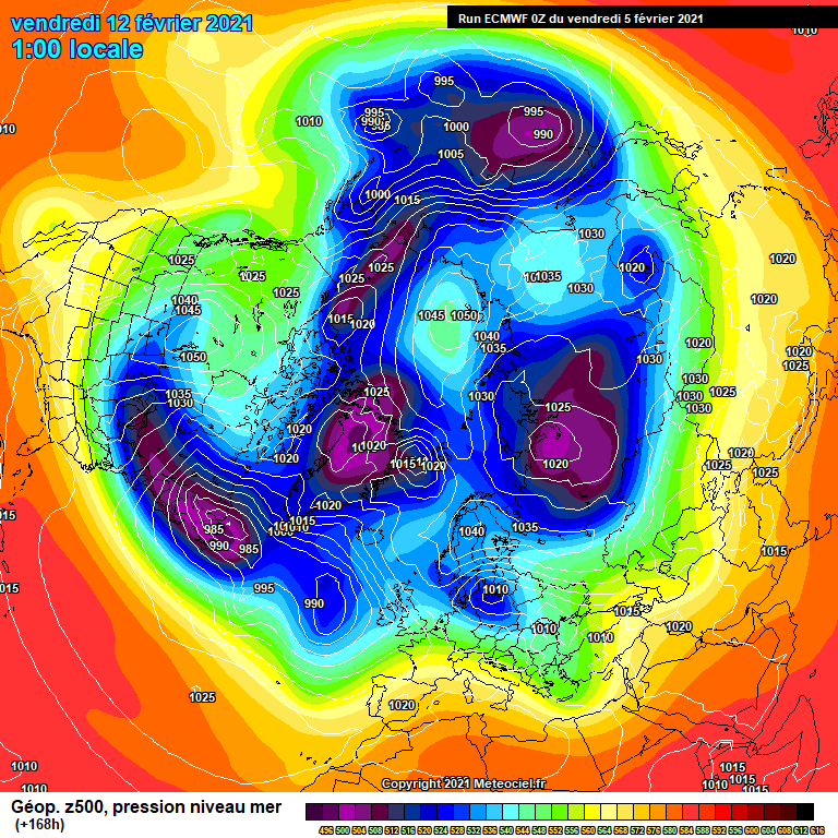
2 hours ago, chris55 said:
GFS is often to progressive, If we take ECM op Vs GFS 6z you can clearly see how GFS is forcing things east to easily. Those little wedges and the dense cold air can have more of an effect than it seems at face value. Steve M was always very good at reading charts like this, but as he's not here ill have a go lol.
GFS 6 z 168
Now look at ECM 168
In some ways i'm wondering if we would be better off if the major low at the end of next week didn't stall but carried on preferrably east but even northeast would do, so long as it advanced beyond the meridian. What causes this low system to stall - the temporary ridge extending down from Iceland on ECM 168 or the surface high over Scandi? Is this an example of high latitude heights not always assisting the chase for cold. I do of course understand that without the heights around griceland in the first place, we would never be in such an exciting pattern now.
-
1
-
-
3 hours ago, The Rock said:
Do they not do snow depths for Ireland
Look closer - there is 10 snowflakes showing for the Sperrins in Tyrone & 6 snowflakes for the Wicklow mountains. It's not all bad!!
-
2
-


.gif.a97aa48311795190851a6b365b546a5e.gif)
.gif.83e996ae9224adb9d4d22881f964371e.gif)


Ireland Regional Weather Discussion
in Ireland Weather Discussion
Posted
I think we would be closer to freezing daytime if we had managed to get some snow on the ground. Central belt of Scotland has an amber warning until 11pm tonight after getting heavy falls overnight. East Ulster coasts require winds a little south of east to get decent snowfall in sunshine & showers set ups.
Very disappointing overnight model runs, though i'll give it until tonight's runs before folding the cards. It looked last night like momentum was moving towards cold. How those models flip / flap so much - so much wasted time following the threads for weeks if we are to get nothing of substance.