


Kirkcaldy Weather
-
Posts
6,673 -
Joined
-
Last visited
-
Days Won
11
Content Type
Forums
Blogs
Gallery
Events
Learn About Weather and Meteorology
Community guides
Posts posted by Kirkcaldy Weather
-
-
Views on Lanark cams showing what I was generally expecting with snow falling but ground temperatures being a bit unsupportive for laying snow. Though snowstorms can have fairly large differences in snow depths across short distances which I'd not be shocked seeing repeated.
Discover Lanark
WWW.LANARK.CO.UK
Explore our new website and discover all that Lanark, New Lanark and the Falls of Clyde have to offer for visitors and locals.-
 2
2
-
-
With the flow starting to switch into the East this gets some north sea convection going as can be seen on the radar between Stonehaven and Aberdeen, a cracking view of this here currently..
 North Webcam - Seacroft Marine Consultants
WWW.SEACROFTMARINE.COM
North Webcam - Seacroft Marine Consultants
WWW.SEACROFTMARINE.COM-
5
-
-
- Popular Post
Quite an intriguing storm system this and I did always say the orientation would be a big player as it usually is when looking at snowstorms, generally the more elongated cyclones are better with cylindrical being less so and looks as if we'll get a combo this time.
The ground temperatures also tell a great story
We see during the approach of the storm ground temperatures are roughly 0 to 1C.
With the #1 ingredient the Dewpoint these start the day below freezing for many of us and itl be a gradual movement to less favourable
These give an idea that many of us could have snow falling but having a tricky time laying, then more of a wintry mix.
Another factor is the wind, hence why IMO it still deserves to be reffered to as a snowstorm with a large swathe of the precip being snow and gusts being such as ..
Significant waves being drawn into the East Coast too
Check the windchill values
 some parts with at least 3 consecutive days of sub zero windchill and as the storm moves north some places nearing minus double digits
Normally one of the key parameters I watch for snowfall is the 528 dam but interesting in this storm it actually isn't present during most of the snow.
The actual isotherm tells a story fitting what I've discussed as the snow height gradually increases.
With snowstorms even tweaks in parameters which may seem small often have large affects, I say pretty much all of us are probable to see snow falling just a question how much can lay given the ground temperatures and winds though again all of us cannot discount a dusting at the least.
Heading through the remainder of Feb week 2 and into week 3 it's looking lovely with the building of high pressure likely some good sunshine on offer


 as covered in my post yesterday the wet conditions become focused into Italy and the Ionian, Adriatic and Mediterranean regions as our current storms energy transfers into a cut off low.
Though this is not the main period of interest with regard to further wintry conditions its not without interest, though the 850hpa temperatures are probable of being above average
The flow will be switching toward more of an easterly which could give below average surface temps during this timeframe
With continuing retrograding into week 3 of February the blocking heads northwest to Greenland and the Atlantic and Scandinavian trough become our focus.
Moisture plume w Jet Interaction from the Caribbean has begun

-
10
-
 8
8
-
Very detailed outlook discussing the dynamics from this point and extending for the majority of February 🌨🌨🌨

 ️️🌩
️️🌩
-
5
-
1
-
-
- Popular Post
Super amount of work went into this one

 🌨🌨
🌨🌨
-
9
-
2
-
Longer post showing the dynamics at play leading into week 2 of February [and beyond]
Starting with developments for the rest of February week 1 into the start of week 2 as mentioned in my post here
"I do expect we'll have the PNA getting more into a negative setup during week 1 of Feb into the first part of week 2 with feedback of MJO phase 6"
'With the influence of more of a -PNA paired to MJO phase 6 I'd not be shocked seeing potential for a storm as the associated troughing crosses the UK between February 8th > 12th''
To understand the dynamics at play for the next major event for the UK / Ireland we need to look at events which have taken place over in Newfoundland and in particular Nova Scotia
This is the same cyclone which will come into the UK and Ireland through the February 8th - 12th period.
The influencing section of the Jet Stream for this system can be tracked from the Caribbean Island Chain into Portugal and the UK
On the Northern and Northwest flanks of the snowstorm we'll have the potential for significant amounts of snow, I wouldn't be one bit shocked seeing areas within the region of a foot of snow perhaps a bit more with current signals of these totals into the Pennines perhaps parts of Scotland, Ireland also a possible area of Northern Wales.
"Also increased threat of flash flooding into Portugal and extending across southern Europe in association with an increasingly strengthening Jet Stream in this region also within that timeframe."
As southern parts of the UK remain in a milder sector of the storm and connected to the section of the Jet Stream mentioned above the flash flood risk could extend into England perhaps Wales with a chance of thunderstorms. This flash flood threat looks to also move into Morocco places such as Casablanca and Rabat with some snow as it moves further inland.
During this timeframe we also see the Maritimes High extending into the US East Coast feedback from the trend to more of a negative PNA and MJO phases 5 and particularly 6
As the UK storm and associated troughing gradually moves East it will see quite a rapid weakening as an increasingly strengthening area of high pressure begins to develop further to it's east. This will force the trough energy southwards and this becomes a cut off low into Italy and the Adriatic, Inonian and Mediterranean also regions a bit east of here.
This leads into my discussions from my post here
"Looking to the 2nd and latter half of February with the MJO currently being in a phase 7 for the last days of January This gives the following feedback
From my post on Thursday which is linked above
''With continuing phase 6 starting to transition into phase 7 and pairing to a re emerging and strengthening +PNA as we get toward and past Mid February there will be lots of tantalising charts''
During this timeframe we'll also see a VERY impressive negative Arctic Oscillation with values perhaps exceeding those which preceeded the severe cold outbreaks of December 2023 and January 2024.
During February week 2 the 500hpa setups will begin to retrograde taking us into the MJO phase 7 patterns with a retrograding trough moving Southwest through Scandinavia and potential for further snowstorms toward Nova Scotia - Newfoundland and from Canada > Maritimes through Northern and Northeast America, also developments in line with the +PNA of cyclonic systems from the Gulf remain a possibility.
Full sequence
Also during week 3 of February the ongoing stratospheric warming looks set to keep intensifying with possibilities for a 2nd reversal of zonal winds this winter
I first discussed the liklihood of stratospheric warming in my post here


-
1
-
-
As the Gulf Cyclone moved east northeast it produced a plethora of tornadic supercells with a significant tor in Valdosta Georgia
-
- Popular Post
Quite a significant flash flood event for Northwest > West Scotland over the next day or so due to the boundary of cold and mild air which creates a bit of an Atmospheric river.
Little update on the snowstorm / blizzard, still coming in for this timeframe and many outputs still looking tasty
-
12
-
2
-
-
On 29/01/2024 at 14:25, Kirkcaldy Weather said:
Continuing trough and noteable cold across Alaska too.
On 29/01/2024 at 14:25, Kirkcaldy Weather said:Looking to the 2nd and latter half of February with the MJO currently being in a phase 7 for the last days of January This gives the following feedback
I'm really liking the CFS for this period already matching really great.
January phase 7 does give a window for colder conditions from the Northeast perhaps Easterly at times.
Further excellent representation continues to frequent the expected timeframes.
Following on from my post here
"As things stand we're looking at at least two weeks of the MJO being active in the Pacific roughly January 24/25 through January 7th but the extended data is supportive ATM of a 3rd week still prominent within the Pacific Taking the progress into / nearer Mid January "
Again the CFS has performed best and my overall thoughts above are generally how it's going, there is an interesting trend over the past few days between the CFS and GEFS suggesting a significant slowing of the MJOs progression out of the Pacific, i suspect this could have a bit of the stratospheric warmings influence here and also keeps the trend of said warming to continue further beyond mid February which is already being suggested within multiple modelling.
Ignore the lines crossing the page must be erranoues data.
We'll continue seeing patterns which are favourable precursors for continuing stratospheric warming too. C3-2, C2-2 & C3-3 in particular.
Say it again
EL NINÒ

-
7
-
1
-
-
Definitely need to bring this out again for this month's setups
-
2
-
-
From my recent post in the Scottish thread
''With the influence of more of a -PNA paired to MJO phase 6 I'd not be shocked seeing potential for a storm as the associated troughing crosses the UK between February 8th > 12th"
Exciting scenarios appearing within this timeframe, dependant on orientation of the low(s) but definitely potential here for a snowstorm - blizzard within the UK / possibly Ireland.
Also increased threat of flash flooding into Portugal and extending across southern Europe in association with an increasingly strengthening Jet Stream in this region also within that timeframe.
With continuing phase 6 starting to transition into phase 7 and pairing to a re emerging and strengthening +PNA as we get toward and past Mid February there will be lots of tantalising charts

Absolutely Textbook El Ninò, simply stunning 500hpa evolutions
Original post: https://community.netweather.tv/topic/99814-model-output-discussion-22nd-jan-2024-onwards/?do=findComment&comment=5027650-
2
-
-
- Popular Post
- Popular Post
From my recent post in the Scottish thread
''With the influence of more of a -PNA paired to MJO phase 6 I'd not be shocked seeing potential for a storm as the associated troughing crosses the UK between February 8th > 12th"
Exciting scenarios appearing within this timeframe, dependant on orientation of the low(s) but definitely potential here for a snowstorm - blizzard within the UK / possibly Ireland.
Also increased threat of flash flooding into Portugal and extending across southern Europe in association with an increasingly strengthening Jet Stream in this region also within that timeframe.
With continuing phase 6 starting to transition into phase 7 and pairing to a re emerging and strengthening +PNA as we get toward and past Mid February there will be lots of tantalising charts
Absolutely Textbook El Ninò, simply stunning 500hpa evolutions
-
10
-
4
-
On 30/01/2024 at 20:28, Kirkcaldy Weather said:
With the influence of more of a -PNA paired to MJO phase 6 I'd not be shocked seeing potential for a storm as the associated troughing crosses the UK between February 8th > 12th


Exciting scenarios appearing within this timeframe, dependant on orientation of the low(s) but definitely potential here for a snowstorm - blizzard within the UK / possibly Ireland.
Also keeping a watch for increased risk of flash flooding impacts for Portugal which could extend across Southern Europe as an increasingly strong Jet Stream moves across the region also in this time period.
-
9
-
-
-
On 23/01/2024 at 18:12, Kirkcaldy Weather said:
As the cut off low(s) [troughing] gradually progresses east and in connection with more of a classical +PNA setup we'll have a system which has potential of becoming a potentially disruptive snowstorm into Northeast America, I'm expectant of this during the 28th - 30th of January
Excellent
Models did become confident on Newfoundland doing particularly well from this snowstorm
On 23/01/2024 at 18:12, Kirkcaldy Weather said:From the last days of Jan through week 1 of Feb this will have a significantly wet anomaly for California up the US west coast into the Pacific Northwest and moving into the Southwest States and Mexico. Some of the precip will fall as snow in higher terrains such as the Sierras.
We'll see 2 simultaneous cyclones bringing an increased liklihood of flash flooding, as the first which is currently coming into the west coast begins to traverse southeastwards it brings a significant flash flood threat into the Gulf States and we get our classic El Ninò setup / appearance.
With the Gulf cyclone I expect significant flash flood impacts between February 3rd and February 9th with this gradually moving east Northeast, might be a chance for a transition from rain to wintry precip - snow on the northwest flank as the cyclone approches the Carolina coast however this could also remain just offshore.
Some extreme amounts currently shown for Feb 4th somewhere in Louisianna such as Pilottown etc
-
2.3C and 100.8mm please
-
- Popular Post
Wind warnings out for tomorrow certainly strongest across the Western Isles pushing into the Northwest probably over toward the Great Glen with somewhat of a weakening as the front moves southeast across Scotland though still gusts topping 50+ mph.
Nice posts by @Jo Farrow as storm Ingunn develops and heads into Scandinavia, this is feedback from recent MJO phase progression which can be seen with phases 4 , 5 and 6 in particular for January
following this cold front we'll have some colder air coming in again most significant for the Northwest & North with some snow for the Northwest
Not sure who in here has read my recent posts
''Following on from this as the preceeding MJO phases input begins to feed into the setups from week 4 of Jan onward the above remains true with further developments.
Looks like this initial cut off low will develop into a +PNA during the very end of Jan"
As the positive PNA feedback progresses eastward pairing with the MJO patterns I've covered in depth, a +PNA does have a tendency of being supportive for Atlantic ridging / blocking which moves in the direction of Greenland and in connection to a trough further east ie Scandinavia, Baltic regions which gives a doorway for something cooler > colder from the north.''
'Though I'm not putting a massive amount of emphasis into exact timeframes from my POV ATM it's looking favoured for this by approx February 4th / 5th and starting to see a possible redux around 1 week later ie 11th / 12th February.'
I do expect we'll have the PNA getting more into a negative setup during week 1 of Feb into the first part of week 2 with feedback of MJO phase 6
With the influence of more of a -PNA paired to MJO phase 6 I'd not be shocked seeing potential for a storm as the associated troughing crosses the UK between February 8th > 12th
As mentioned in my posts lately heading into the 2nd half of February quite the tasty setups loom with a re emerging positive PNA pairing to MJO phases 6 and 7
Truly spoilt for choice in February we've got the ongoing stratospheric warming which increases in strength during half 1 of Feb incoming too

-
11
-
5
-
Warnings issued


Starting to get a cleaner idea of the likely direction / evolutions through February and heading into March, firstly I'd like to show whats been happening with the below average temperatures zone I mentioned which is running across the southern regions of the Northern Hemisphere
Azerbaijan & Iran
The colder temperatures at surface and upper levels will gradually continue eastward and move across Asia by one of the timeframes I'll talk about in a sec.
'As the positive PNA feedback progresses eastward pairing with the MJO patterns I've covered in depth, a +PNA does have a tendency of being supportive for Atlantic ridging / blocking which moves in the direction of Greenland and in connection to a trough further east ie Scandinavia, Baltic regions which gives a doorway for something cooler > colder from the north'
"Though I'm not putting a massive amount of emphasis into exact timeframes from my POV ATM it's looking favoured for this by approx February 4th / 5th and starting to see a possible redux around 1 week later ie 11th / 12th February."
Looking like a decent set of estimates and further excellent representation of exactly what I'd expect from the MJO feedback.
Low pressures crossing the UK in particular the northern portions which feed into the Scandinavian trough developments, Troughing and aforementioned colder conditions into Asia > East Asia, High pressure / block across the East > Northeast of America and the Maritimes with further above average temperatures no surprises from my POV on that. Continuing trough and noteable cold across Alaska too.
Looking to the 2nd and latter half of February with the MJO currently being in a phase 7 for the last days of January This gives the following feedback
I'm really liking the CFS for this period already matching really great.
January phase 7 does give a window for colder conditions from the Northeast perhaps Easterly at times.
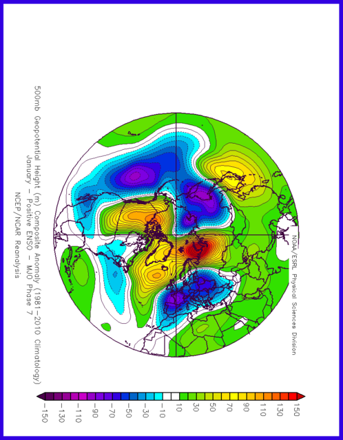
Moving forward a February phase 7 sees feedback bringing high pressure development to our East Northeast and extending across the UK
Both of these setups can be seen in the below
With the supportive precursors and MJO the stratospheric warming did indeed begin in small amounts during week 4 of January and as the MJO influence within the Pacific takes place the warming increases during the first half of February
Prime time showcase of El Ninò in February
We might have a brief re entry of phase 6 during week 1 of February though there is no complete agreement for this, however it's relatively similar to the setups currently materialising should it occur.
We'll continue seeing patterns which link to El Ninò throughout March and I'd favour potentially the first few weeks or so of April, following that time it's a gradual move into ENSO Neutral with some themes continuing of heading into La Ninà by late spring and particularly Summer 2024.
As 2012>2013 is among my top analogues it wouldn't be shocking for relatively similar setups to occur should MJO progression be conducive and potential feedback of stratospheric events.
Original post: https://community.netweather.tv/topic/99814-model-output-discussion-22nd-jan-2024-onwards/?do=findComment&comment=5026092-
1
-
-
- Popular Post
- Popular Post
Warnings issued
Starting to get a cleaner idea of the likely direction / evolutions through February and heading into March, firstly I'd like to show whats been happening with the below average temperatures zone I mentioned which is running across the southern regions of the Northern Hemisphere
Azerbaijan & Iran
The colder temperatures at surface and upper levels will gradually continue eastward and move across Asia by one of the timeframes I'll talk about in a sec.
'As the positive PNA feedback progresses eastward pairing with the MJO patterns I've covered in depth, a +PNA does have a tendency of being supportive for Atlantic ridging / blocking which moves in the direction of Greenland and in connection to a trough further east ie Scandinavia, Baltic regions which gives a doorway for something cooler > colder from the north'
"Though I'm not putting a massive amount of emphasis into exact timeframes from my POV ATM it's looking favoured for this by approx February 4th / 5th and starting to see a possible redux around 1 week later ie 11th / 12th February."
Looking like a decent set of estimates and further excellent representation of exactly what I'd expect from the MJO feedback.
Low pressures crossing the UK in particular the northern portions which feed into the Scandinavian trough developments, Troughing and aforementioned colder conditions into Asia > East Asia, High pressure / block across the East > Northeast of America and the Maritimes with further above average temperatures no surprises from my POV on that. Continuing trough and noteable cold across Alaska too.
Looking to the 2nd and latter half of February with the MJO currently being in a phase 7 for the last days of January This gives the following feedback
I'm really liking the CFS for this period already matching really great.
January phase 7 does give a window for colder conditions from the Northeast perhaps Easterly at times.
Moving forward a February phase 7 sees feedback bringing high pressure development to our East Northeast and extending across the UK
Both of these setups can be seen in the below
With the supportive precursors and MJO the stratospheric warming did indeed begin in small amounts during week 4 of January and as the MJO influence within the Pacific takes place the warming increases during the first half of February
Prime time showcase of El Ninò in February
We might have a brief re entry of phase 6 during week 1 of February though there is no complete agreement for this, however it's relatively similar to the setups currently materialising should it occur.
We'll continue seeing patterns which link to El Ninò throughout March and I'd favour potentially the first few weeks or so of April, following that time it's a gradual move into ENSO Neutral with some themes continuing of heading into La Ninà by late spring and particularly Summer 2024.
As 2012>2013 is among my top analogues it wouldn't be shocking for relatively similar setups to occur should MJO progression be conducive and potential feedback of stratospheric events.
-
4
-
9
-
Wouldn't be surprised seeing a bit of flooding and potential rainfall warnings particularly for parts of Wales most likely Northwest and into Northwest England into Tuesday with increasingly heavy precip running along the boundary of colder and milder temperatures.
-
4
-
-
Events Across China January 2024
cold and snow
Heat / warm temperatures
BOTH
-
1
-
-
-
As mentioned in my post here
"With the above we can see some of the important 500hpa setups developing into our current timeframe and into week 4 of January (and beyond)
Low pressures from Greenland and into the Arctic
High pressure forming across the Maritimes. A secondary high toward the Northwest of the US and Canada which links with PNA behaviour more on that shortly.
Formation of cut off low(s) in that southwestern America > Mexico regions which also will lead into PNA behaviour.'
'Following on from this as the preceeding MJO phases input begins to feed into the setups from week 4 of Jan onward the above remains true with further developments.
Looks like this initial cut off low will develop into a +PNA during the very end of Jan"
As the positive PNA feedback progresses eastward pairing with the MJO patterns I've covered in depth, a +PNA does have a tendency of being supportive for Atlantic ridging / blocking which moves in the direction of Greenland and in connection to a trough further east ie Scandinavia, Baltic regions which gives a doorway for something cooler > colder from the north.
Though I'm not putting a massive amount of emphasis into exact timeframes from my POV ATM it's looking favoured for this by approx February 4th / 5th and starting to see a possible redux around 1 week later ie 11th / 12th February.
Original post: https://community.netweather.tv/topic/99814-model-output-discussion-22nd-jan-2024-onwards/?do=findComment&comment=5024752-
2
-


Global interconnected weather - Model Output, Pattern Drivers plus Impact worldwide
in Hurricanes, Cyclones and Extreme weather worldwide
Posted
Lovely patterns in line with the teleconnections continuing to materialise with a great setup for some significant snowy cyclonic developments from February 11th through at least 1 week thereafter as low pressure from southwestern America / Mexico moves Northeastwards with a track as mentioned previously through Northern and Northeast America and particularly Newfoundland and Nova Scotia


Heading through week 3 of February remains the next significant setup for potential wintry conditions with a building high in Greenland and retrograding Scandinavian trough as energy connections begin with the trough in the Atlantic