


Kirkcaldy Weather
-
Posts
6,682 -
Joined
-
Last visited
-
Days Won
11
Content Type
Forums
Blogs
Gallery
Events
Learn About Weather and Meteorology
Community guides
Posts posted by Kirkcaldy Weather
-
-
On 11/04/2024 at 20:28, Kirkcaldy Weather said:
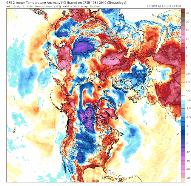
As shown in my post from October and other occasions a negative PNA can lead to a cold - potentially significantly cold temperature anomaly from the Northeast-East

Recent GFS outputs.
Quite exceptional performance from the GFS particularly with the European cold anomalies.
On 17/04/2024 at 22:06, Kirkcaldy Weather said:Overall a prolonged period with below average temperatures will continue with some significant anomalies across Europe in particular, we then look during April week 4 as the High retrograde gets going for these below average conditions to extend into the UK > Ireland.
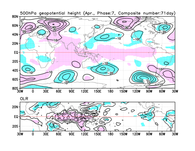
The UK, Europe and North + Northwest Africa Cold Anomaly can be noted here within recent MJO feedback.
On 17/04/2024 at 22:06, Kirkcaldy Weather said:
During the latter stage of April week 3 through April week 4 the Atlantic and Ireland-UK high will begin to take on the MJO and PNA feedback of blocking to our Northeast > Scandinavia and Russia, this will also retrograde into Iceland and Greenland as discussed prior with a good representation of many of the major European weather regimes / teleconnective feedback.
As low pressure interacts with the below average temperature airmass we'll have a mix of wintry conditions with increasing precip moving in tonight combining with a Lowering Isotherm this will fall as snow particularly across Northern Scotland and parts of Northern England, predominantly higher elevations with accumulating snow though mixing of sleet snow and maybe hail can't be ruled out at low levels. We'll have the 528 dam and low isotherm values present for a number of days especially for Northern England and Scotland with a focal point clinging onto the North Sea Coastlines. We'll see multiple chilly nights with frosts for some areas worth noting for gardeners, all in all very noteworthy given its April week 4.
Could be a brief window for above average temperatures during the first days of May as High Pressure looks to build to our East.
Currently this looks to be brief warmth as this high retrogrades and reinforces the prominent theme for further high pressure and blocking to our North Northeast and particularly Northwest with trends hinting at the Atlantic Ridge regime by May week 2 with further trough developments to our East & NorthEast.
All fits excellently with feedback of El Ninò, IOBW warm phase, SSW, PNA and NAO in particular.
Credit JMA
 KW
KW
-
 2
2
-
 1
1
-
-
11.8C and 79.8mm please
-
-
-
I've already discussed that a lower amplitude cycle of the MJO's global progression was going to occur and also a feature linking to El Ninò but I thought this would be a good example which links with my post back in July.
A great example again that a low amplitude MJO cycle can still give active weather conditions.
Currently the main part of the MJO is travelling from South America through Africa and into the Indian Ocean. [Credit JMA]
This will enhance what I believe is a CCKW - Convectively Coupled Kelvin Wave from South Africa. As the MJO moves across South Africa and enhances the CCKW this sees significant rainfall and flash flood risks particularly off the coast of Tanzania & Kenya with places such as Zanzibar and Pemba Island prone.
Current timing shows the MJO starting to move across the Maritimes during April week 4 into May week 1. As the CCKW moves Southeastwards the significant rainfall impacts could extend into Madagascar similar to recent weeks.
I've discussed the teleconnective feedback playing into our ongoing 500hpa developments and looking into the MJO composites with recent and ongoing progression of this cycle not surprising seeing high pressure - blocking being a prominent feature again trends continuing into Greenland. The UK trough / Low Pressure can also be noted within these MJO phase feedback. There may be opportunities for some high pressure extending toward the UK and Ireland at times though there isnt any concrete signal for this in current modelling though the 00z GEPS did hint toward the latter part of May week 1.
-
 3
3
-
1
-
1
-
-
-
'Tornadoes' leave trail of destruction across UK: Country is battered as gale force winds and 450 lightning strikes wreak havoc - damaging homes and cars and overturning caravans | Daily Mail Online
WWW.DAILYMAIL.CO.UK
The first possible tornado struck Knutton in Staffordshire, damaging cars and ripping off tiles at about 6.30am - before the second swept through the West Bridgford area of Nottingham at 7.30am.
‘Tornado’ hits town as strong winds batter the UK
WWW.AOL.CO.UK
Parks, bridges and tourist attractions across the UK were closed on Monday due to the windy weather conditions.The very active weather will continue to evolve throughout Europe with multiple significant weather events.
Snow
Ongoing significant snowfalls continuing across the Alps.
Another potentially significant snow event could swing back into Albania, Kosovo, current trends really keen into Montenegro, Bosnia and Herzegovina, perhaps North Macedonia and parts of West and Southwestern Serbia, this event currently modelled for Sunday and Monday.
There is also an ongoing snow event from the Belarusian border crossing Russia with significant accumulations.
And another area of snow intensifying as it moves across Norway again further significant accumulations likely.
Significant flash flood threat.
A significant rainfall event will develop through Saturday into Sunday across Greece and moving into Turkey, after crossing the Black Sea this could continue bringing a significant flash flood risk into Moldova and Ukraine and possibly Belarus.
-
On 29/01/2024 at 14:25, Kirkcaldy Weather said:
We'll continue seeing patterns which link to El Ninò throughout March and I'd favour potentially the first few weeks or so of April, following that time it's a gradual move into ENSO Neutral with some themes continuing of heading into La Ninà by late spring and particularly Summer 2024.
Want to start by revisiting the above statement from January, there can often be discrepancies between the various Meteorological Agencies particularly regarding ENSO statuses but we have BOM first to declare ENSO Neutral.
Per my recent post here
I discussed that the Super El Ninò Event had transitioned into more of a West Based Event, the latest ENSO discussion from NOAA agrees and gives further info
We'll have to await JMA and NOAA anouncing ENSO Neutral conditions and personally I dont get involved in debates a la Twitter last year with many arguing we weren't in an El Ninò though as I have discussed prior no 2 ENSO events behave indentically though there are common characteristics of each ENSO, and there can be lag in the Oceanic > Atmospheric 'coupling'.
Newest ENSO outlooks from Met Office suggest ENSO Neutral heading into May with the oncoming La Nina conditions intensifying in the 1 & 2 Regions quite fast.
Starting to see more details to add to some of my recent posts.
On 11/04/2024 at 20:28, Kirkcaldy Weather said:We can watch as the extremely cold airmass associated with the Tropospheric Vortex begins to move from the Russian end of the Arctic across toward the Alaskan and Canadian end. Values at -28C 850hpa ongoing possibly some nearing -30C and still maintaining at least -24C at 850hpa upon the position shift.
On 11/04/2024 at 20:28, Kirkcaldy Weather said:Trends show the coldest conditions becoming centred across Europe.
On 11/04/2024 at 20:28, Kirkcaldy Weather said:From now through Mid April we see the Atlantic Ridge regime which could extend across Ireland possibly the UK for a time, with this transitioning into blocking to our Northeast, North and most likely Greenland too.
Looking in more detail, the most significant developments upcoming, as the cyclonic system discussed here
Merges with a cut off low in Northwest America this will link to the Tropospheric Vortex which is modelled to greatly intensify with indication potentially record breaking low pressure into Canada.
Part of the MJO Indian Ocean > Maritimes feedback in an El Ninò in April as posted prior
As shown in my recent post we continue to see the Atlantic Ridge in an El Ninò setup with another cold plunge during the next few days.
Following on we have the high pressure moving into Ireland and the UK as mentioned prior plus as the Tropospheric Vortex developments occur in Canada this paired to the Negative PNA will see a high descending from West Canada across America with a new Arctic air outbreak, a relatively common pattern of the last few months which I've covered in the global thread. This will bring significantly below average temperatures.
On 11/04/2024 at 20:28, Kirkcaldy Weather said:As shown in my post from October and other occasions a negative PNA can lead to a cold - potentially significantly cold temperature anomaly from the Northeast-East
During the latter stage of April week 3 through April week 4 the Atlantic and Ireland-UK high will begin to take on the MJO and PNA feedback of blocking to our Northeast > Scandinavia and Russia, this will also retrograde into Iceland and Greenland as discussed prior with a good representation of many of the major European weather regimes / teleconnective feedback.
Euro-Atlantic weather Regimes in the PRIMAVERA coupled climate simulations: impact of resolution and mean state biases on model performance
LINK.SPRINGER.COM
Recently, much attention has been devoted to better understand the internal modes of variability of the climate system. This is particularly important in mid-latitude regions like...Nothing surprising here factoring in recent MJO progression with an ongoing probable further feedback of multiple Stratospheric > Sudden Stratospheric Warming Events, *though the current zonal winds are above average.
Overall a prolonged period with below average temperatures will continue with some significant anomalies across Europe in particular, we then look during April week 4 as the High retrograde gets going for these below average conditions to extend into the UK > Ireland.
Thanks for reading. KW
Original post: https://community.netweather.tv/topic/99814-model-output-discussion-spring-has-sprung/?do=findComment&comment=5058911 -
- Popular Post
- Popular Post
On 29/01/2024 at 14:25, Kirkcaldy Weather said:We'll continue seeing patterns which link to El Ninò throughout March and I'd favour potentially the first few weeks or so of April, following that time it's a gradual move into ENSO Neutral with some themes continuing of heading into La Ninà by late spring and particularly Summer 2024.
Want to start by revisiting the above statement from January, there can often be discrepancies between the various Meteorological Agencies particularly regarding ENSO statuses but we have BOM first to declare ENSO Neutral.
Per my recent post here
I discussed that the Super El Ninò Event had transitioned into more of a West Based Event, the latest ENSO discussion from NOAA agrees and gives further info
We'll have to await JMA and NOAA anouncing ENSO Neutral conditions and personally I dont get involved in debates a la Twitter last year with many arguing we weren't in an El Ninò though as I have discussed prior no 2 ENSO events behave indentically though there are common characteristics of each ENSO, and there can be lag in the Oceanic > Atmospheric 'coupling'.
Newest ENSO outlooks from Met Office suggest ENSO Neutral heading into May with the oncoming La Nina conditions intensifying in the 1 & 2 Regions quite fast.
Starting to see more details to add to some of my recent posts.
On 11/04/2024 at 20:28, Kirkcaldy Weather said:We can watch as the extremely cold airmass associated with the Tropospheric Vortex begins to move from the Russian end of the Arctic across toward the Alaskan and Canadian end. Values at -28C 850hpa ongoing possibly some nearing -30C and still maintaining at least -24C at 850hpa upon the position shift.
On 11/04/2024 at 20:28, Kirkcaldy Weather said:Trends show the coldest conditions becoming centred across Europe.
On 11/04/2024 at 20:28, Kirkcaldy Weather said:From now through Mid April we see the Atlantic Ridge regime which could extend across Ireland possibly the UK for a time, with this transitioning into blocking to our Northeast, North and most likely Greenland too.
Looking in more detail, the most significant developments upcoming, as the cyclonic system discussed here
Merges with a cut off low in Northwest America this will link to the Tropospheric Vortex which is modelled to greatly intensify with indication potentially record breaking low pressure into Canada.
Part of the MJO Indian Ocean > Maritimes feedback in an El Ninò in April as posted prior
As shown in my recent post we continue to see the Atlantic Ridge in an El Ninò setup with another cold plunge during the next few days.
Following on we have the high pressure moving into Ireland and the UK as mentioned prior plus as the Tropospheric Vortex developments occur in Canada this paired to the Negative PNA will see a high descending from West Canada across America with a new Arctic air outbreak, a relatively common pattern of the last few months which I've covered in the global thread. This will bring significantly below average temperatures.
On 11/04/2024 at 20:28, Kirkcaldy Weather said:As shown in my post from October and other occasions a negative PNA can lead to a cold - potentially significantly cold temperature anomaly from the Northeast-East
During the latter stage of April week 3 through April week 4 the Atlantic and Ireland-UK high will begin to take on the MJO and PNA feedback of blocking to our Northeast > Scandinavia and Russia, this will also retrograde into Iceland and Greenland as discussed prior with a good representation of many of the major European weather regimes / teleconnective feedback.
Euro-Atlantic weather Regimes in the PRIMAVERA coupled climate simulations: impact of resolution and mean state biases on model performance
LINK.SPRINGER.COM
Recently, much attention has been devoted to better understand the internal modes of variability of the climate system. This is particularly important in mid-latitude regions like...Nothing surprising here factoring in recent MJO progression with an ongoing probable further feedback of multiple Stratospheric > Sudden Stratospheric Warming Events, *though the current zonal winds are above average.
Overall a prolonged period with below average temperatures will continue with some significant anomalies across Europe in particular, we then look during April week 4 as the High retrograde gets going for these below average conditions to extend into the UK > Ireland.
Thanks for reading. KW
-
7
-
1
-
4
-
- Popular Post
Most well defined rain shaft I've witnessed in a long time.


-
12
-
1
-
- Popular Post
- Popular Post
Most well defined rain shaft I've witnessed in a long time.

-
14
-
On 09/04/2024 at 03:48, Kirkcaldy Weather said:
Looks like another Rossby Wave Break Event is likely by next weekend though exact positions of cut off lows and high pressure TBD
As the cut off low across West America via this Rossby Wave Break Event transitions into Northern States the next significant flash flood threat will evolve as the cyclonic system enters Iowa.
Newest data suggesting highest precip rates at the border of Nebraska, South Dakota and Iowa, with the flash flood threat moving into Minnesota and Wisconsin then progressing Northeastwards.
Severe weather associated with this event too.
-
On 07/04/2024 at 19:34, Kirkcaldy Weather said:
Heading toward Mid April I'm watching for a plunge of Arctic air as troughing develops to the North of the UK and moves toward Scandinavia and Europe bringing a flow from the Northwest and North.
Active period of weather with this.
Number of dynamics going on, we have a cold front which will be finishing its journey through Ireland and the UK by midday Monday.
With a strengthening Jet Streak interacting with the cold front there are a few heightened threats these being increased wind gusts with trends for embedded potentially damaging gusts and also a potential for tornadic activities embedded along the cold front I'd suggest parts of Ireland and also Wales and Southwest England being particularly at risk though it's a wide area overall.
To the Northeast of this active Jet Streak we have a deep cold pool moving in at 500hpa, this corresponding brilliantly with a pool of increased instability meaning the showers having a higher expectation of being thundery in nature and combining to the Lowering Isothermic values a wintry mix with snow mostly at high levels though not exclusively with hail and sleet to lower levels. Northwest, North and Northeast England and Scotland seeing the most of this activity.
As this Arctic plunge descends through Europe this brings yet another significant snowfall event across the Alps, a very repetitive and common occurence during this El Ninò. I'm also noticing the signal of a significant snow event in Bosnia and Herzegovina from Wednesday through Friday.
Original post: https://community.netweather.tv/topic/99814-model-output-discussion-spring-has-sprung/?do=findComment&comment=5057797 -
On 07/04/2024 at 19:34, Kirkcaldy Weather said:
Heading toward Mid April I'm watching for a plunge of Arctic air as troughing develops to the North of the UK and moves toward Scandinavia and Europe bringing a flow from the Northwest and North.
Active period of weather with this.
Number of dynamics going on, we have a cold front which will be finishing its journey through Ireland and the UK by midday Monday.
With a strengthening Jet Streak interacting with the cold front there are a few heightened threats these being increased wind gusts with trends for embedded potentially damaging gusts and also a potential for tornadic activities embedded along the cold front I'd suggest parts of Ireland and also Wales and Southwest England being particularly at risk though it's a wide area overall.
To the Northeast of this active Jet Streak we have a deep cold pool moving in at 500hpa, this corresponding brilliantly with a pool of increased instability meaning the showers having a higher expectation of being thundery in nature and combining to the Lowering Isothermic values a wintry mix with snow mostly at high levels though not exclusively with hail and sleet to lower levels. Northwest, North and Northeast England and Scotland seeing the most of this activity.
As this Arctic plunge descends through Europe this brings yet another significant snowfall event across the Alps, a very repetitive and common occurence during this El Ninò. I'm also noticing the signal of a significant snow event in Bosnia and Herzegovina from Wednesday through Friday.
-
5
-
4
-
-
Ski resorts Australia: First snow falls on ski fields almost eight weeks ahead of winter
WWW.9NEWS.COM.AU
The first snow of winter has fallen at Australian ski resorts in NSW and Victoria.
First Aussie mainland snow of 2024
WWW.WEATHERZONE.COM.AU
Snow has fallen overnight in Australia's mainland ski resorts and continues to tumble down on Tuesday morning as a cold front sweeps across southeast Australia. As a heavy band of moisture... -
Recent cold temperature records - low maximums & minimums via NOAA
*Temperatures in Fahrenheit
India
South Africa
Australia
Argentina
Chile
-
-
First 20C of the year yesterday with a max of 20.1C
32 minutes ago, SW Saltire said:approximately 110mm for the month so far
Similar here sitting on 114.13mm so far.
-
3
-
-
Tonnes of fascinating evolutions occuring teleconnectively


I'll start by revisiting the Arctic Oscillation which I discussed here
On 02/04/2024 at 21:04, Kirkcaldy Weather said:With the teleconnective pairing of the move from a strong -NAO toward positive NAO values with recent stronger +AO values we'll see a focus of troughing and cyclonic developments more centering effects for Northwest and Northern UK and Ireland with a building of higher pressure having greater impacts toward southernmost UK and Europe.
Taking the data from the above post
Easy to see the -AO event has become even stronger than anticipated, the strongest positive values for a long time and stronger than during the whole entire winter season.
On 07/04/2024 at 19:34, Kirkcaldy Weather said:All fitting in ideally with expectations this is an excellent teleconnective configuration for significantly cold air to be entreched across the Arctic I expect helping the Arctic Ice too
We can watch as the extremely cold airmass associated with the Tropospheric Vortex begins to move from the Russian end of the Arctic across toward the Alaskan and Canadian end. Values at -28C 850hpa ongoing possibly some nearing -30C and still maintaining at least -24C at 850hpa upon the position shift.
On 07/04/2024 at 19:34, Kirkcaldy Weather said:Heading toward Mid April I'm watching for a plunge of Arctic air as troughing develops to the North of the UK and moves toward Scandinavia and Europe bringing a flow from the Northwest and North.
This can be noted from the above animations but delving slightly deeper.
Trends show the coldest conditions becoming centred across Europe.
Very fascinating setup hemispherically we've got a number of Rossby Wave Break Events.
I have already discussed most of these and some of their impacts here
Focusing on the North Pacific this looks the most impressive and set to continue development into an ongoing Rossby Wave Train - RWT
We also have a developing Rossby Wave Break Event from the North Atlantic through Europe and North Africa by Mid April 14th > 15th.
The right hand cut off low will be part of the significant cold temperatures across North Africa as discussed in my post in the global temperature thread however this will also bring a significant flash flood risk as a significant rainfall event occurs in Tunisia extending into Northeast and North Algeria.
To fully understand the upcoming developments beyond this timeframe we need to look in detail at recent and ongoing teleconnective developments.
To do this I'd like to revisit my posts from the start of January, January 20th and March 4th.
Beginning with the MJO and El Ninò, a lower amplitude cycle was always going to occur and upon doing research this is a common occurence during the latter stages of strong/super El Ninò Events with the following excerpts from
"The eastward propagation of MJO was also observed during the decaying stages of the three super El Niño events, but its intensity was weaker compared with the developing and mature stages."
"3.3 Decaying stages
The eastward propagation of the MJO could be observed during the decaying stages of the three super El Niño, but their intensity, duration and propagation distance were significantly weakened compared with those in the developing and mature stages (Figure 2). The spatiotemporal spectral analysis in Figure 3 also showed that power spectrum of intraseasonal eastward propagation during the decaying stages of the 1997/98 and 2015/16 El Niño events were relatively stronger than those during the 1982/83 El Niño. The central periods of the eastward propagation for the MJO were mainly 40 days and 75 days during the decaying stages of 1997/98 El Niño, and it was primarily 40 days for the 2015/16 El Niño. However, there is no center of intraseasonal eastward propagation during the 1982/83 El Niño. The strong wave of eastward and westward propagation of lager than 90 days appeared in the decaying stages of the 1982/83 and 1997/98 El Niño events, which may be induced by the conversion of the MJO energy to low-frequency energy of above 90 days (Li and Zhou, 1994; Li and Li, 1995). At the same time, the high-frequency wave activities of the eastward propagation were prominent at 20–30 days during the decaying stages of the 1997/98 El Niño. In addition, the eastward propagation center of zonal wave 2 was detected during the decaying stages of the 1982/83 El Niño.
The evolution and composite results of the RMM index during decaying stages of three super El Niño illustrated that the MJO activity in the decaying stages is significantly weaker than that in the developing and mature stages. The MJO intensity in the decaying stages was the weakest, especially for the 1982/83 and 1997/98 El Niño events (Figure 2; Figure 4; Figure 5). The RMM indexes of phase 4–8 during the decaying stages of the 1997/98 and 2015/16 El Niño changed from positive anomaly in the mature stages to negative anomalies, particularly in phase 6–8 (Figure 5C). The strong MJO activity led to the increase in the average RMM index of phase 4-5 in May 1998. The two robust MJO activities in June and July 2016 also enhanced the average RMM index of phase 1-2 during the decaying stages of the 2015/16 El Niño. Many studies had indicated that the robust MJO activity in May 1998 triggered the easterly anomalies, resulting in the termination of El Niño. After the MJO event, the Niño 3.4 index rapidly decayed from positive anomaly to negative anomaly (Takayabu et al., 1999; Miyakawa et al., 2017). Figure 2 showed that during the decaying stages of three super El Niño, when Niño 3.4 index turned from positive to negative, the MJO easterly existed in the eastern Pacific, which demonstrated that the MJO easterlies may accelerate the extinction of strong El Niño. Meanwhile, the MJO westerlies in April 1998 and June 2016 existed in the eastern Pacific, while the decaying rate of the Niño 3.4 index was prominently reduced. The anomalous MJO zonal wind amplitudes in the Indian Ocean and Pacific were weakened in the decaying stages, especially in the 1982/83 and 1997/98 El Niño, while they were enhanced in the central and eastern Pacific, particularly in the 2015/16 (Figure 6). The MJO zonal wind amplitudes strengthened over the eastern Pacific, which may lead to the stronger 2015/16 El Niño. These results indicate that the MJO plays a critical role in the decaying stages of El Niño while it is necessary to further study the interaction between the MJO and the decaying stages of El Niño."
Taking the MJO progression of late we see this evolution occuring again with the lowest amplitude involved with progression across the Indian Ocean.
There are many areas of importance and interest here.
With ongoing discrepancies between all models on amplitude and progression / timing of this cycle its no surprise seeing associated differences within the outputs which will continue until this is worked out however there are patterns which are increasingly probable given recent progression and continuing feedback of El Ninò which I will discuss below.
As I discussed in my posts during January it's not overly shocking seeing the MJO decreasing in amplitude across the Indian Ocean given interesting recent developments involving the Indian Ocean Dipole.
Taking the data from my post in January the IOD looked to weaken markedly and be at neutral - potentially negative by this current timeframe.
Met Office
BOM
This weakening close to neutral has occured but a re-emergence into positive IOD conditions are occuring a bit earlier and stronger than those outlooks.
Newest Data courtesy of Met Office and BOM
Other seasonal models also trending into more of a noticeable +IOD
Looking at upcoming developments and revisiting my post from October
"I've enjoyed researching the PNA further extending more information than the bits I knew already and having found multiple papers there's a clear connection with the PNA and upstream blocks either Scandi Greenland or a mix of both which stems from Rossby Wave Breaking in most scenarios as we are and have witnessed lately."
We are seeing the most negative PNA since Late February.
Pairing this with the MJO in the Indian Ocean and the Maritimes in April in an El Ninò plus feedback typically seen in association with El Ninò
From now through Mid April we see the Atlantic Ridge regime which could extend across Ireland possibly the UK for a time, with this transitioning into blocking to our Northeast, North and most likely Greenland too.
As shown in my post from October and other occasions a negative PNA can lead to a cold - potentially significantly cold temperature anomaly from the Northeast-East
Recent GFS outputs.
Thanks for reading, KW

 ️
️
Original post: https://community.netweather.tv/topic/99814-model-output-discussion-spring-has-sprung/?do=findComment&comment=5057116 -
- Popular Post
- Popular Post
Tonnes of fascinating evolutions occuring teleconnectively
I'll start by revisiting the Arctic Oscillation which I discussed here
On 02/04/2024 at 21:04, Kirkcaldy Weather said:With the teleconnective pairing of the move from a strong -NAO toward positive NAO values with recent stronger +AO values we'll see a focus of troughing and cyclonic developments more centering effects for Northwest and Northern UK and Ireland with a building of higher pressure having greater impacts toward southernmost UK and Europe.
Taking the data from the above post
Easy to see the -AO event has become even stronger than anticipated, the strongest positive values for a long time and stronger than during the whole entire winter season.
On 07/04/2024 at 19:34, Kirkcaldy Weather said:All fitting in ideally with expectations this is an excellent teleconnective configuration for significantly cold air to be entreched across the Arctic I expect helping the Arctic Ice too
We can watch as the extremely cold airmass associated with the Tropospheric Vortex begins to move from the Russian end of the Arctic across toward the Alaskan and Canadian end. Values at -28C 850hpa ongoing possibly some nearing -30C and still maintaining at least -24C at 850hpa upon the position shift.
On 07/04/2024 at 19:34, Kirkcaldy Weather said:Heading toward Mid April I'm watching for a plunge of Arctic air as troughing develops to the North of the UK and moves toward Scandinavia and Europe bringing a flow from the Northwest and North.
This can be noted from the above animations but delving slightly deeper.
Trends show the coldest conditions becoming centred across Europe.
Very fascinating setup hemispherically we've got a number of Rossby Wave Break Events.
I have already discussed most of these and some of their impacts here
Focusing on the North Pacific this looks the most impressive and set to continue development into an ongoing Rossby Wave Train - RWT
We also have a developing Rossby Wave Break Event from the North Atlantic through Europe and North Africa by Mid April 14th > 15th.
The right hand cut off low will be part of the significant cold temperatures across North Africa as discussed in my post in the global temperature thread however this will also bring a significant flash flood risk as a significant rainfall event occurs in Tunisia extending into Northeast and North Algeria.
To fully understand the upcoming developments beyond this timeframe we need to look in detail at recent and ongoing teleconnective developments.
To do this I'd like to revisit my posts from the start of January, January 20th and March 4th.
Beginning with the MJO and El Ninò, a lower amplitude cycle was always going to occur and upon doing research this is a common occurence during the latter stages of strong/super El Ninò Events with the following excerpts from
"The eastward propagation of MJO was also observed during the decaying stages of the three super El Niño events, but its intensity was weaker compared with the developing and mature stages."
"3.3 Decaying stages
The eastward propagation of the MJO could be observed during the decaying stages of the three super El Niño, but their intensity, duration and propagation distance were significantly weakened compared with those in the developing and mature stages (Figure 2). The spatiotemporal spectral analysis in Figure 3 also showed that power spectrum of intraseasonal eastward propagation during the decaying stages of the 1997/98 and 2015/16 El Niño events were relatively stronger than those during the 1982/83 El Niño. The central periods of the eastward propagation for the MJO were mainly 40 days and 75 days during the decaying stages of 1997/98 El Niño, and it was primarily 40 days for the 2015/16 El Niño. However, there is no center of intraseasonal eastward propagation during the 1982/83 El Niño. The strong wave of eastward and westward propagation of lager than 90 days appeared in the decaying stages of the 1982/83 and 1997/98 El Niño events, which may be induced by the conversion of the MJO energy to low-frequency energy of above 90 days (Li and Zhou, 1994; Li and Li, 1995). At the same time, the high-frequency wave activities of the eastward propagation were prominent at 20–30 days during the decaying stages of the 1997/98 El Niño. In addition, the eastward propagation center of zonal wave 2 was detected during the decaying stages of the 1982/83 El Niño.
The evolution and composite results of the RMM index during decaying stages of three super El Niño illustrated that the MJO activity in the decaying stages is significantly weaker than that in the developing and mature stages. The MJO intensity in the decaying stages was the weakest, especially for the 1982/83 and 1997/98 El Niño events (Figure 2; Figure 4; Figure 5). The RMM indexes of phase 4–8 during the decaying stages of the 1997/98 and 2015/16 El Niño changed from positive anomaly in the mature stages to negative anomalies, particularly in phase 6–8 (Figure 5C). The strong MJO activity led to the increase in the average RMM index of phase 4-5 in May 1998. The two robust MJO activities in June and July 2016 also enhanced the average RMM index of phase 1-2 during the decaying stages of the 2015/16 El Niño. Many studies had indicated that the robust MJO activity in May 1998 triggered the easterly anomalies, resulting in the termination of El Niño. After the MJO event, the Niño 3.4 index rapidly decayed from positive anomaly to negative anomaly (Takayabu et al., 1999; Miyakawa et al., 2017). Figure 2 showed that during the decaying stages of three super El Niño, when Niño 3.4 index turned from positive to negative, the MJO easterly existed in the eastern Pacific, which demonstrated that the MJO easterlies may accelerate the extinction of strong El Niño. Meanwhile, the MJO westerlies in April 1998 and June 2016 existed in the eastern Pacific, while the decaying rate of the Niño 3.4 index was prominently reduced. The anomalous MJO zonal wind amplitudes in the Indian Ocean and Pacific were weakened in the decaying stages, especially in the 1982/83 and 1997/98 El Niño, while they were enhanced in the central and eastern Pacific, particularly in the 2015/16 (Figure 6). The MJO zonal wind amplitudes strengthened over the eastern Pacific, which may lead to the stronger 2015/16 El Niño. These results indicate that the MJO plays a critical role in the decaying stages of El Niño while it is necessary to further study the interaction between the MJO and the decaying stages of El Niño."
Taking the MJO progression of late we see this evolution occuring again with the lowest amplitude involved with progression across the Indian Ocean.
There are many areas of importance and interest here.
With ongoing discrepancies between all models on amplitude and progression / timing of this cycle its no surprise seeing associated differences within the outputs which will continue until this is worked out however there are patterns which are increasingly probable given recent progression and continuing feedback of El Ninò which I will discuss below.
As I discussed in my posts during January it's not overly shocking seeing the MJO decreasing in amplitude across the Indian Ocean given interesting recent developments involving the Indian Ocean Dipole.
Taking the data from my post in January the IOD looked to weaken markedly and be at neutral - potentially negative by this current timeframe.
Met Office
BOM
This weakening close to neutral has occured but a re-emergence into positive IOD conditions are occuring a bit earlier and stronger than those outlooks.
Newest Data courtesy of Met Office and BOM
Other seasonal models also trending into more of a noticeable +IOD
Looking at upcoming developments and revisiting my post from October
"I've enjoyed researching the PNA further extending more information than the bits I knew already and having found multiple papers there's a clear connection with the PNA and upstream blocks either Scandi Greenland or a mix of both which stems from Rossby Wave Breaking in most scenarios as we are and have witnessed lately."
We are seeing the most negative PNA since Late February.
Pairing this with the MJO in the Indian Ocean and the Maritimes in April in an El Ninò plus feedback typically seen in association with El Ninò
From now through Mid April we see the Atlantic Ridge regime which could extend across Ireland possibly the UK for a time, with this transitioning into blocking to our Northeast, North and most likely Greenland too.
As shown in my post from October and other occasions a negative PNA can lead to a cold - potentially significantly cold temperature anomaly from the Northeast-East
Recent GFS outputs.
Thanks for reading, KW
️
-
5
-
8
-
On 09/04/2024 at 03:48, Kirkcaldy Weather said:
This Rossby Wave Break Event is transitioning into an ongoing significant flash flood threat which intensifies particularly though not exclusively toward the Gulf Coast States over the next few days.
-
-
-
Whilst there will be ongoing MJO feedback some additional significant teleconnective developments of late giving a global temperature evolution featuring noteworthy amounts of cold / below average - significantly below average temperature scenarios throughout both Southern and Northern Hemispheres.
The switch back into a strongly positive AAO [Antarctic Oscillation] which has been a persisting feature of this El Ninò will continue to have feedback across the Southern Hemisphere especially.
However the main influence I believe will be the recent evolution of the 2023-2024 Super El Ninò into more of a west based El Ninò which occurs with Western Pacific ENSO regions [3,3.4 &4] being noteably warmer than Eastern Pacific ENSO regions [1&2]
We can see this evolution via the NOAA ENSO SST animations upto April 3rd
And via the 15 day smoothed means from cyclonicwx
Doing my research I found the typical April temperature setup during a West Based El Ninò bearing in mind no two ENSO events are ever 100% identical and other teleconnective feedback also factors in, however it is a good match to the temperature evolutions from now through the next 10 days at least.
One of the most noteable below average anomalies is across Australia, there were many cold records broken following cyclone Megan last month and I wouldn't be one bit shocked seeing further records tied and/or broken.
Sticking in the Southern Hemisphere there are other noteworthy significant below average temperature anomalies in South America and South Africa.
Moving to the Northern Hemisphere some of the most significant cold events,
Alaska discussed here
A predominantly cold pattern moving across the Middle East intensifying as we head nearer to Mid April with significantly below average temperatures potentially record breaking I'd imagine.
850hpa and surface temperatures.
Dynamics involved see a new cut off low become very slow moving and maintaining intensity / reintensifying.
Significantly cold temperature anomaly across Tibet.
Cold - significantly cold anomalies will also develop across India particularly Northern India likely in part connecting to the Middle East cut off low / trough.
Multiple cold air outbreaks farther north toward Russia though this looks likely to trend into Higher pressure and associated above - significantly above average temperatures.
Northern Africa seeing a significant cold plunge this coming weekend
Predominantly cool - cold setup initially before a gradual transition into above average, though the below average temperatures in the south are associated with Monsoon rains still noteably colder than average with above average rainfalls.
Global view.
-
1
-


Global interconnected weather - Model Output, Pattern Drivers plus Impact worldwide
in Hurricanes, Cyclones and Extreme weather worldwide
Posted
Interesting small cyclonic system in the Atlantic which has been given 10% to obtain tropical characteristics over the next few days
After decaying this systems moisture will become part of a Rossby Wave Break Event during this weekend into early next week.
Looks like this system spawned from a CCKW from South America
With influence of CCKW activities and the MJO itself mentioned in the above post, there will be a significant - possibly major snow event across the Himalayas as a mix of troughing and cut off lows converge by April 28th. Overall a significantly snowy setup for Russia and Asia with accompanying cold > significantly cold temperature anomalies which will extend into parts of the Middle East.
This once again coinciding with a move into a negative phase of the Arctic Oscillation.
This CCKW and MJO activity will also keep significant rainfall and significant flash flood risk events ongoing across East and Southeast China, Taiwan and Japan through at least May week 1.