
- Popular Post


Nick F
-
Posts
9,889 -
Joined
-
Days Won
18
Content Type
Forums
Blogs
Gallery
Events
Learn About Weather and Meteorology
Community guides
Posts posted by Nick F
-
-
That low that develops off the eastern seaboard along a baroclinic zone left in wake of the storm currently affecting NE USA and heading east over the Atlantic causing a right roller coaster in here for what to expect over Christmas.
The low was held back on the 00z and 06z runs, allowing a cold NWly flow over Christmas Eve, but now on 12z GFS, UKMO and ICON are much more progressive and quicker to merge with the low pressure to the north and northeast of the UK or move the low across northern Britain Xmas Eve - bringing a milder westerly or southwesterly flow.
The saving grace is that the quicker clearance of the low from west to east allows a cold polar flow to follow from the west on 12z GFS through Christmas Day.
But who's to say there won't be a low developing out west along the cold/mild boundary that will scupper this polar incursion shown by GFS on Xmas Day too?
-
 7
7
-
 2
2
-
-
Both GFS and EC take MJO out of COD into phase 1 by the weekend, not the most exciting phase looking at Dec P1 analog composite in Nino, but it does at least suggests, perhaps after a brief spell of mild W or SW winds from around Xmas Day, chances of further polar incursions from the NW or N returning around New Year.

The GEFS day 15 mean looks remarkably similar to the phase 1 analog composite in Nino over N Atlantic and N America - taking into account the lag.
-
2
-
1
-
-
9 minutes ago, Nick F said:
00z EC high res right at the top (mild) end of the T2m temp spread 24-25th for London
Looks like a mild outlier towards the end for T850s for London too on the basic meteociel.fr plots.

-
7
-
 1
1
-
-
- Popular Post
- Popular Post
00z EC high res right at the top (mild) end of the T2m temp spread 24-25th for London
-
6
-
10
-
Well worth a look where the 12z GFS op sits amongst the ensembles when they're out, could well be the cold end or an outlier from around 24th, but may not be if there is a new direction the model is picking up on with regards to developments upstream.
-
5
-
-
- Popular Post
- Popular Post
Oh no, 12z GFS leading us up the garden path again?

Certainly would bring widespread chances for a white Christmas! With the cold hanging on for a few days after too.
-
9
-
1
-
- Popular Post
- Popular Post
Morning, I've been guilty of doing it myself, but it's easy to be drawn in by charts out of the reliable range showing cold setups, especially when they were seemingly consistently shown by GFS. But when the EC has not been showing the same level of amplification upstream and there's a strong jet stream involved, it's often a tall ask to expect the jet stream when it's flat and strong to get far enough south to bring cold air across all parts.
Can imagine there's been a lot of hours put in by some posting on here optimistically speculating and backing up with clusters and ensemble graphs that in some way backed up the cause of a cold snap/spell coming off, alas when the MJO forecast stalled the wave into COD before reaching the favourable 7/8 phases at low amplitude, it started to look like we wouldn't get the amplification late December needed to get decent cold for snow. The last straw was that the TPV drifting over towards Scandinavia may push far enough south over the NE Atlantic to push the jet stream south of the UK, but that looks less likely now too. Scotland could still be prone to cold incursions with risk of snow, especially higher ground as we head to Christmas and beyond.
But for the rest of us, we probably need to kick the can into the New Year and hope the top down weakening of the polar wind field from stratosphere forecast can perhaps induce some high lat blocking in January, but it could be a long wait. In the meantime, there are hints of MJO reawakening over the western Pacific, so that may help bring some amplification in the high latitudes early Jan.
But for now, I'm not going to get too excited by cold and wintry northerlies or easterlies shown past 7-8 days.
-
16
-
1
-
1
-
2 minutes ago, frosty ground said:
Not sure how you get to it’s dire, the solution is slower but also colder
Trouble is, the longer the cold air is delayed getting down across the UK, the more can go wrong with lows developing to the NW or W to quickly cut off the flow. We're talking 9 days away on GFS the cold air pushes across all the UK, that's a long way off in forecasting. so good chance it may change and be even more delayed or not arrive at all.
Original post: https://community.netweather.tv/topic/99584-model-output-discussion-into-winter/?do=findComment&comment=4976446 -
High pressure builds from the south this weekend, bringing drier and more settled weather for England and Wales, though western Scotland will be rather wet. Turning more unsettled and potentially stormy and colder later next week just before Christmas.
-
-
- Popular Post
- Popular Post
2 minutes ago, frosty ground said:Not sure how you get to it’s dire, the solution is slower but also colder
Trouble is, the longer the cold air is delayed getting down across the UK, the more can go wrong with lows developing to the NW or W to quickly cut off the flow. We're talking 9 days away on GFS the cold air pushes across all the UK, that's a long way off in forecasting. so good chance it may change and be even more delayed or not arrive at all.
-
8
-
2
-
3
-
-
-
4 hours ago, Ali1977 said:
528 cleared the U.K., cold dew points, severe wind chill - charts for the end of next week off this run - just one run but pretty mad!!
Oh and 100 mph winds from Greenland
Looks pretty wild for a week's time on 00z GFS and EC, very strong northwesterly jet stream could spawn one or two deep lows late next week onwards. GFS and EC show a deepening low moving southeast from Greenland towards Scotland next Thursday, air becoming cold enough for snow in the north, so could be blizzards given the wind speeds both show.
EC
-
3
-
-
24 minutes ago, Vikos said:
Overall, the route is rather mild‘ish than cold in terms of winter weather conditions…
next stop of hope would be a ssw somewhere in January, but we all know how long it takes to deliver any goods (if at all)…
we have to face it, December isn’t a winter month any more, last one was 13 years ago and was peaking out in a series of mild winters…
Think many on here will disagree with regards to the UK, many saw snow last week, while around 11th/12th Dec 2022 it snowed a lot in places, and Dec 2022 was below average. For Germany in your location, there's been cold and snow this December, e.g, Munich 40cm of snow.
Back to the models, going through the GEFS postage stamps on Xmas Day, hardly any members going for amplification over the Atlantic on Xmas Day, most looking flat, fair few are mild SWly, a few cold zonal or cold NWly.
-
8
-
-
12 minutes ago, Penguin16 said:
Underwhelming ECM. The odd chillier day that’s about it.
It highlights the danger of relying on a very strong and flat jet stream over the N Atlantic to shift south to bring us cold for long enough, the flow needs to be more amplified upstream to give anything more than brief shots of marginally cold air.
GFS buckles the jet stream upstream to the south of Greenland weekend of 23/24, so delays lows moving in from the west enough to get a brief cold blast just before Christmas, before it flattens the jet Christmas onwards, EC just too flat.
We are seeing the typical watering down of cold and flattening out of any amplification when we get nearer when we get these strong upper flows from the NW.
-
6
-
2
-
-
All looks very nice and wintry on 12z GFS from Thursday next week right up to Christmas Day (when mild air invades from the west).
But there is the danger without the amplified flow over N Atlantic, with upper N Atlantic ridge further north into Greenland, that the strong and flat jet stream / sharp baroclinic zone from New Foundland to SW UK could spawn a few lows that could scupper cold getting to the south for long or altogether before Christmas.
We are very reliant in the south for the jet stream to get south of the UK. North looks best placed in this kind of set-up with low heights and more likely to get north of the jet for longer.
When there is not much amplification to work with, we are relying on the trop PV pushing S and E towards UK and Scandinavia to push the jet stream south of the UK. Tall order, but we may get lucky even in the south. Albeit it could be brief without amplification upstream.
Original post: https://community.netweather.tv/topic/99584-model-output-discussion-into-winter/?do=findComment&comment=4975724-
1
-
-
- Popular Post
- Popular Post
All looks very nice and wintry on 12z GFS from Thursday next week right up to Christmas Day (when mild air invades from the west).
But there is the danger without the amplified flow over N Atlantic, with upper N Atlantic ridge further north into Greenland, that the strong and flat jet stream / sharp baroclinic zone from New Foundland to SW UK could spawn a few lows that could scupper cold getting to the south for long or altogether before Christmas.
We are very reliant in the south for the jet stream to get south of the UK. North looks best placed in this kind of set-up with low heights and more likely to get north of the jet for longer.
When there is not much amplification to work with, we are relying on the trop PV pushing S and E towards UK and Scandinavia to push the jet stream south of the UK. Tall order, but we may get lucky even in the south. Albeit it could be brief without amplification upstream.
-
14
-
2
-
5
-
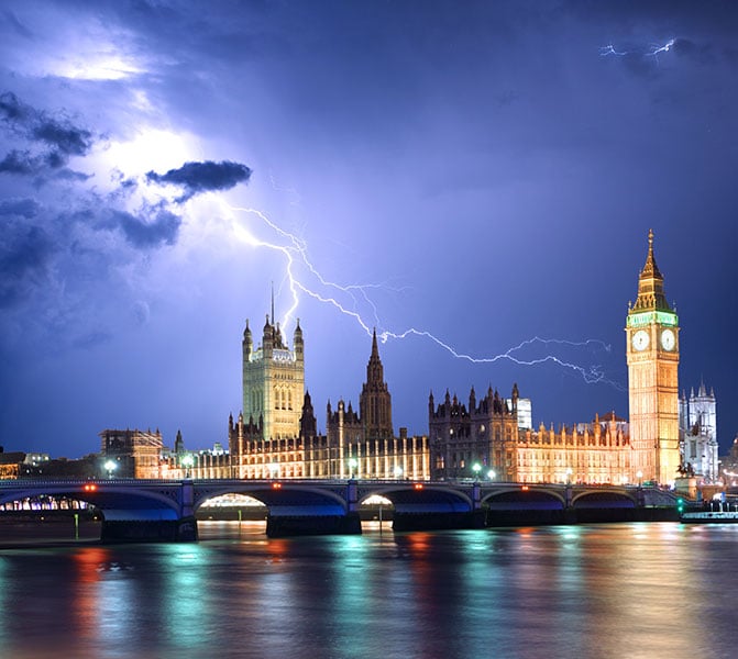
Had some thunder & lightning here in Caterham-on-the-hill with this bad boy moving through London now.
-
4
-
-
Don't think I've seen a 1050 hPa Azores high forecast before, as shown by EC at T+216, perhaps enhanced by the very strong jet arcing across the N Atlantic?
The danger of such a strong jet aimed at the UK is potential for one or two nasty deep lows in the run up to Christmas, which will be in stark contrast from the settled anticyclonic conditions prior taking over later this week.
GFS shows the jet stream pushing further south by and beyond day 10, hence the threat of colder arctic incursions by Christmas, but still bit too far away for my liking to be confident of some cold and wintry weather a few days before and over Christmas. Especially, given the strong jet stream forecast over the N Atlantic, it stays flat and zonal and doesn't sink far enough south. More runs needed.
Original post: https://community.netweather.tv/topic/99584-model-output-discussion-into-winter/?do=findComment&comment=4974812-
1
-
-
Don't think I've seen a 1050 hPa Azores high forecast before, as shown by EC at T+216, perhaps enhanced by the very strong jet arcing across the N Atlantic?
The danger of such a strong jet aimed at the UK is potential for one or two nasty deep lows in the run up to Christmas, which will be in stark contrast from the settled anticyclonic conditions prior taking over later this week.
GFS shows the jet stream pushing further south by and beyond day 10, hence the threat of colder arctic incursions by Christmas, but still bit too far away for my liking to be confident of some cold and wintry weather a few days before and over Christmas. Especially, given the strong jet stream forecast over the N Atlantic, it stays flat and zonal and doesn't sink far enough south. More runs needed.
-
4
-
5
-
-
THUNDERSTORM WATCH - TUES 12 DEC 2023
Issued 2023-12-12 08:46:32
Valid: 12/12/2023 0600 - 13/12/2023 0600Forecast Details
Upper and collocated surface low will move east across England and Wales on Tuesday, upper cold pool will steepen lapse rates across southern Britain, particularly over relatively warmer SSTs which are forecast to generate 200-500 j/kg CAPE, this instability moving inland from the coasts in moist southwesterly flow for a time across Wales, central and southern England ahead of surface low centred over Wales by 15z. Increasing forced ascent of this unstable airmass ahead of the low moving east will support heavy showers and a few brief thunderstorms – which may produce hail, gusty winds and intense rainfall leading to localised flooding. A few funnel clouds or even a brief waterspout/weak tornado can’t be ruled out with stronger updrafts near coasts where relative warmer SSTs will create more buoyancy of air.
Issued by: Nick Finnis
Severe Convective Weather & Storms Forecast - Netweather.tv
WWW.NETWEATHER.TV-
1
-
-
UK Severe Convective & Storm Forecast - Issued 2023-12-12 08:46:32Valid: 12/12/2023 0600 - 13/12/2023 0600Click here for the full forecast
THUNDERSTORM WATCH - TUES 12 DEC 2023-
1
-
-
- Popular Post
- Popular Post
2 minutes ago, Jacob said:Honestly I saw this coming. While people were all doom and gloom about warm weather, you were treating it like it was a few days away when it’s well known that weather models flip all the time, especially in FI
It will lift the doom and gloom for 6 hours, unless the pub run follows suit with a similar stonker of a northerly, then we can wait for a reality check in the morning

-
16


Model Output Discussion - Into Winter
in Forecast Model Discussion
Posted
I'm afraid it's likely another GFS garden path that goes nowhere in the end, like the many we've been chasing down for cold and snow fixes the last few weeks.
Not sure I trust the 12z GFS operational's little wedges of high pressure and little lows over 7 days out.