The stratospheric polar vortex is now in its early stages of development, find out more on how it can influence winter weather patterns.
Like it or loathe it, but the autumn and winter seasons are on the way. The summer period is certainly well and truly behind us, despite whether we end up with some warmer and drier weather through the second half of September.
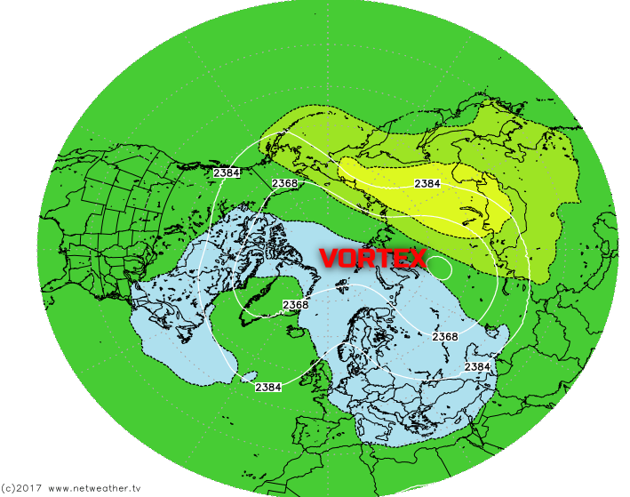
As we progress through September, it is the time of year when the initial development of the stratospheric polar vortex begins to take place. The development of the vortex occurs every year during the autumn period as the polar regions begin to cool. High up in the stratosphere, near 30miles (50km) or so above the earth’s surface, a low-pressure area starts to develop at this time of year and with polar-westerly winds then become apparent. As the polar region continues to cool, the area of low pressure develops further and, by the time we get into October and November, a significant area of very cold air, with associated low-pressure, is in evidence over the northern polar regions.
Now, the importance of this feature is that, amongst other variables, of course, the stratospheric polar vortex can play a significant role in determining the weather across the northern hemisphere through the autumn and, particularly, the winter period. If you’re wondering how some meteorological event so high up in the atmosphere can influence the weather at the surface, then there’s a lot of scientific reasons why, but the connection is well known.
Through the winter period, depending on some situations and circumstances the stratospheric polar vortex can weaken, but also strengthen. At times the whole winter period can be dominated by a strong, compact and powerful vortex, the winter weather that usually develops from a UK’s point of view, is often one dominated by a strong westerly jet stream across the N Atlantic. This weather pattern brings wet and windy conditions to the UK, often frequently and persistently. However, at times, the vortex can weaken, or, particularly importantly, can break down and this can then lead to the potential, at least, of cold weather spilling down from polar regions into the UK and other areas.
So, let’s take a look at the two primary states of the stratospheric polar vortex and how this can influence the weather across the UK and the northern hemisphere.
Cold Stratosphere:
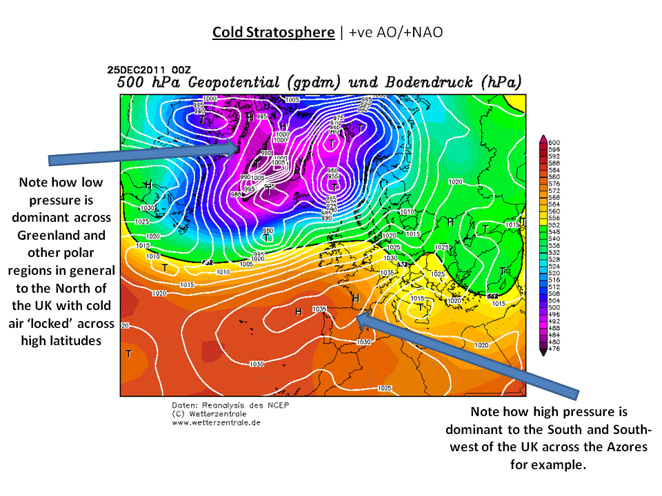
When the stratosphere is particularly cold, sometimes with temperatures as low as -70C, the associated vortex is incredibly powerful. Strong westerly winds within the stratosphere can propagate downwards into the troposphere, the part of the atmosphere where all our weather occurs, and help to promote an active jet stream. The resultant weather across the N Atlantic is one where low pressure dominates over Greenland, while high pressure dominates over the Azores and a zonal jet stream pattern develops.
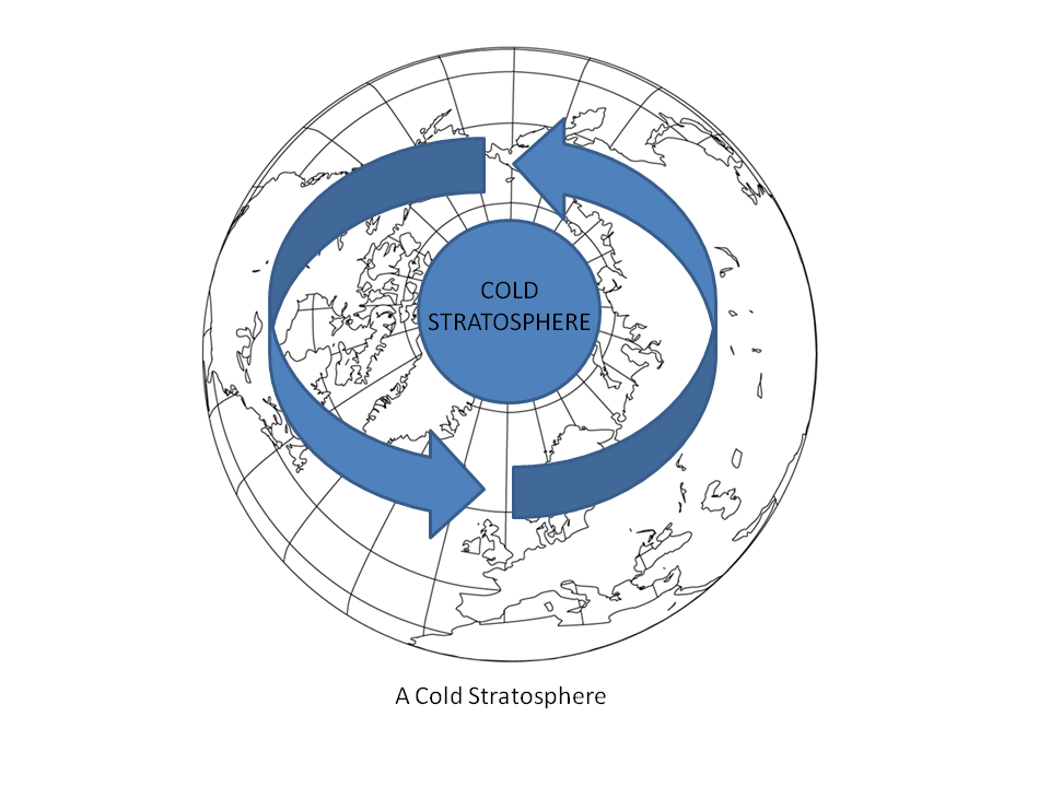
There have been some examples of that over the years, most recently being the winter of 2013/2014 which brought some extremely stormy conditions. Equally, another example is from the Christmas period of 2011. All these examples are very similar, but as shown in the below analysis from Christmas Day in 2011, a pronounced region of low pressure dominates to the north of the British Isles. In contrast, higher pressure is in evidence to the south, with a zonal flow in evidence across the N Atlantic. This pattern is also known as a +ve NAO (North Atlantic Oscillation) and a +ve AO (Arctic Oscillation).
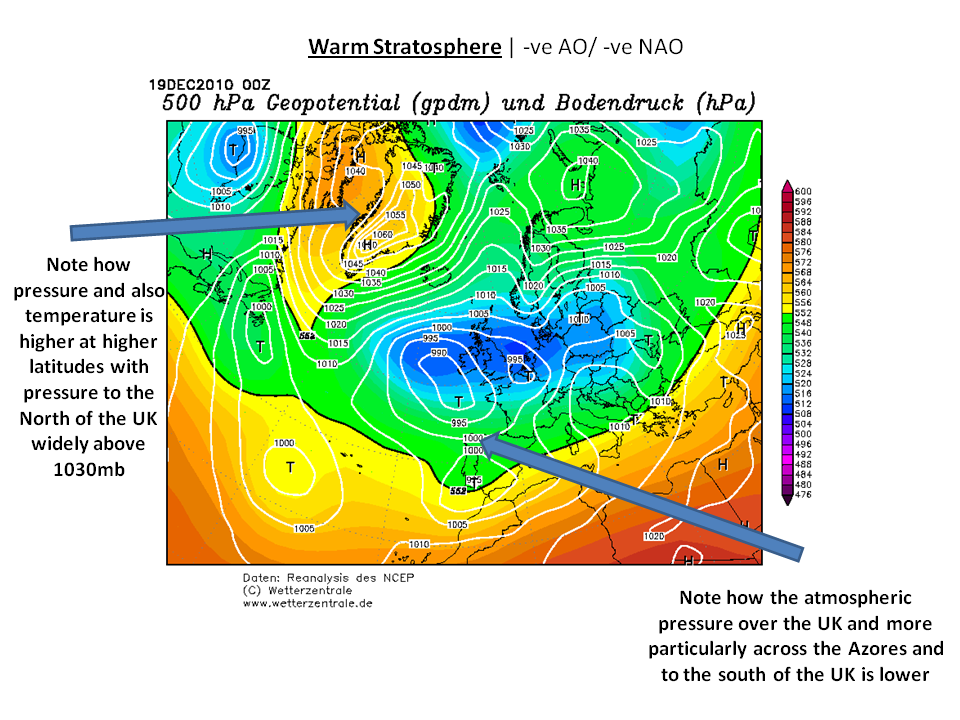
Warm Stratosphere:
Now, this is often the essential part of the autumn and winter season. The natural progression through autumn and into winter is for the stratosphere to cool. However, depending on some circumstances and variables, there are times when the stratospheric polar vortex can come under ‘attack’. Essentially what this means is that warmer conditions can become entrained into the polar region and this can help disrupt the vortex, or, importantly, break it down. When this occurs, the natural flow of westerly winds within the stratosphere degrades, and this is when there is the potential for colder weather to develop across the UK. This development of warmer conditions entering into the polar regions can help to promote what is known as ‘northern blocking’. What this means is that higher pressure can replace the lower pressure that often dominates across polar regions. When areas of high pressure become established across northern latitudes during the winter period, this increases the potential for colder air to flood southwards towards the UK and across other landmasses across the northern hemisphere, rather than the cold air being locked away to the north.
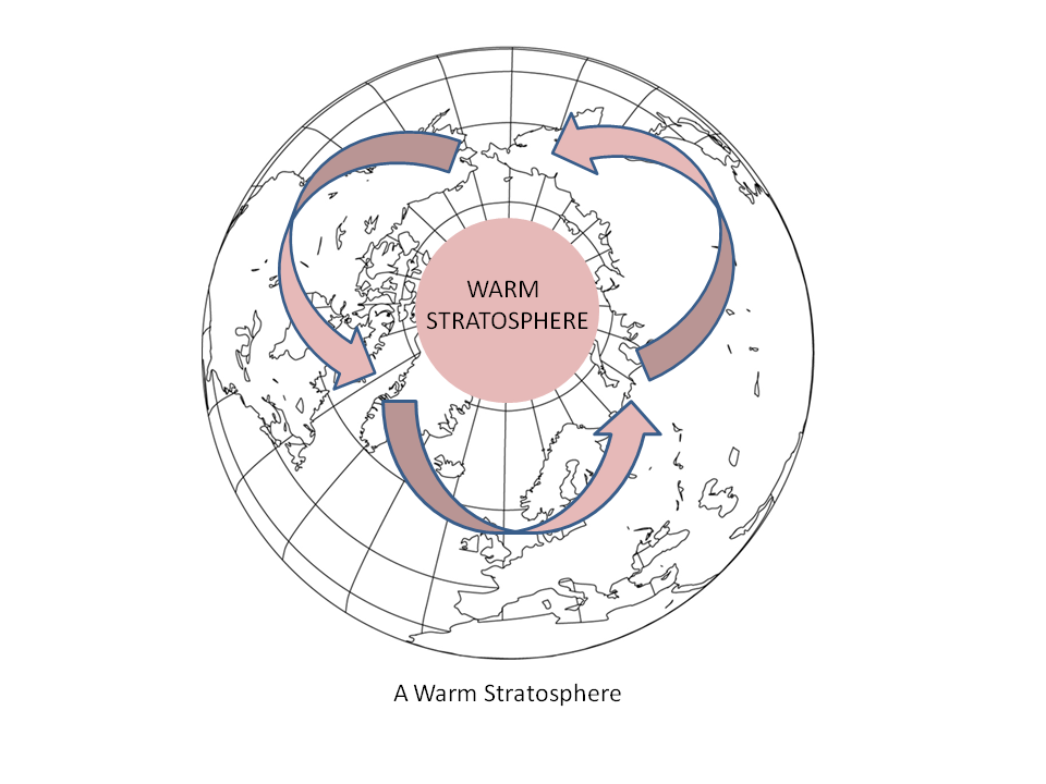
Now, the perfect example of a highly disrupted vortex, due to what is known as a sudden stratospheric warming, was back in December 2010. I’m sure many will remember that December for being very cold indeed and with the persistent wintry weather not lasting for days, but for weeks. Now, if you compare the below chart to the previous one, you’ll notice a distinct difference. High pressure has replaced the low pressure over Greenland, and this also extends eastwards towards northern areas of Scandinavia. It is on the southern flank of this region of high pressure that freezing polar air is allowed to filter down, out of the polar regions often on north, north-easterly or easterly winds. This pattern is also known as a –ve NAO (North Atlantic Oscillation) regime, along with a –ve AO (Arctic Oscillation).
Latest Developments
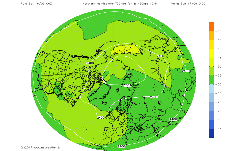
At the moment the stratospheric polar vortex is in its early stages of development. The temperatures across the polar regions, within the stratosphere, are quite uniform with little variation, the meteorological name for this is a barotropic environment. The latest GFS model, into Sunday 19th, highlights this initial development.
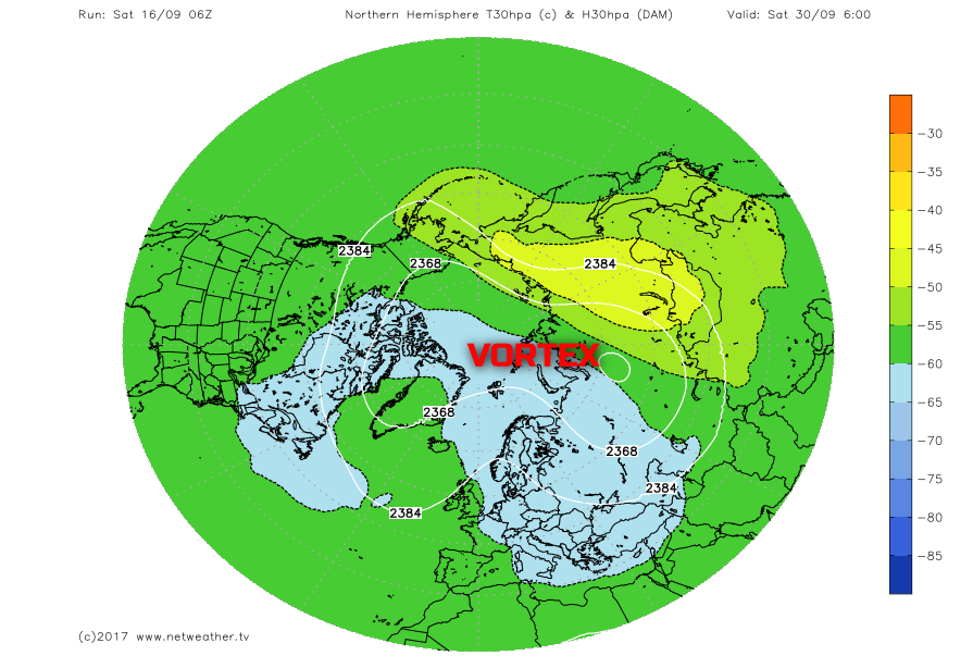
However, if we progress through the forecast sequence to the end of September you can see that the temperatures across the polar regions have continued to cool, currently forecast to be below -60C, as the overall development of the vortex continues, albeit still in a rather weak state.
As we continue to progress into October and November, then the vortex should continue to strengthen. Wind speeds within the stratosphere will steadily increase, as the westerly flow develops and the temperatures will continue to fall. As we get into November and then particularly into December, all eyes will then be on the development of the vortex at that point. If, like in the example above, from December 2011, the vortex is well compact and a ‘cold vortex’, then early winter could well be dominated by generally unsettled and wet and windy conditions. However, depending on other variables there could well be the potential for the vortex to already be under some duress, potentially putting the vortex into a more weakened state. If that were to occur then, possibly, the early winter period could well see a greater risk of some colder, more blocked weather patterns developing.
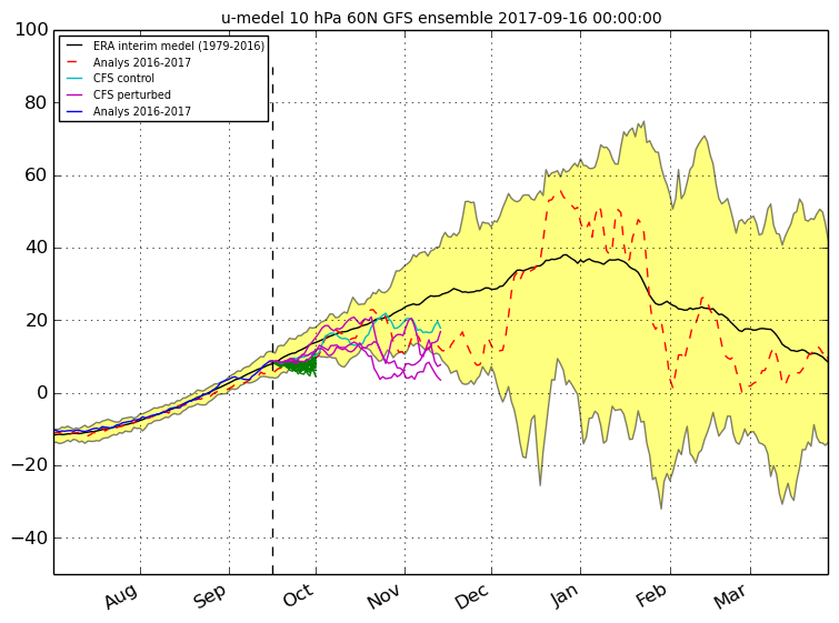
One forecast model, from the CFS, does indicate that as we progress into November, the vortex may well be weaker than would normally be expected. This is exampled by pink lines on the graph below generally being lower than the solid black line, which portrays the mean wind speeds within the stratosphere at that particular time of year. Many factors can impact on the development of the stratospheric vortex, but a couple of interesting ones this year are the expected development of an easterly phase of the QBO (Quasi-Biennial Oscillation) which can help to disrupt the natural westerly winds of the vortex. Equally, we continue to progress towards a solar minimum, of which was the case around 2009/2010. There is some evidence to suggest that when the sun is less active, so in a minimum solar period, the overall stratospheric vortex is less intense, or at least has a greater potential to be broken down.
So, here’s to the coming weeks and months to see how the vortex may develop and behave as we progress through the remainder of autumn and as early winter approaches. For those of you out there that long after cold and wintry weather, then you’ll need to hope for a disrupted vortex this winter. Equally, if no-one wants a repeat of the stormy winter from 2013/2014, for example, then a less organised vortex would be of some help there too. It is of worth to emphasise though that the stratospheric polar vortex does not independently and directly drive the winter weather patterns, there are other factors too. However, as experience and examples have shown us, it does have a significant influence at times, especially when it's either in a pronounced cold phase or a warm one, as discussed.