|
|
Winter Forecast 2010/11
This forecast issued on the 18th October 2010 and written by our long range expert Stewart Rampling is a technical and in depth seasonal forecast for Winter 2010/11. Usually only available to commercial clients of Netweather.tv, it is being made freely available this year in addition to the usual long range forecasts and features that are available on the site.
Will it, won't it ? But the dryness will be the real story
Following back to back cold winters for much of the UK, there is a lot of focus whether this year will follow suit. However, with temperatures forecast to be close to or slightly below average, we believe the most significant aspect of this winter will be the very much below average winter rainfall following on the back of a largely dry summer for parts of the UK and very likely dry spring to follow.
Headline Summary:
- Anomalously cold ocean temperatures in the Tropical Pacific or La Nina conditions have become well established. There is a high probability that these conditions will intensify over the coming months and become one of the strongest La Ninas on record.
- With a strong coupling between the atmosphere and ocean signal, global weather patterns are very likely to be forced by a strong La Nina with dominant high pressure centres in the northern Pacific and in the North Atlantic.
- La Nina winters have a variable influence on the weather in Europe although we anticipate no sustained extremes of cold and the emphasis on dry, settled weather. Some wintry weather is however expected, particularly during mid to late December an early January.
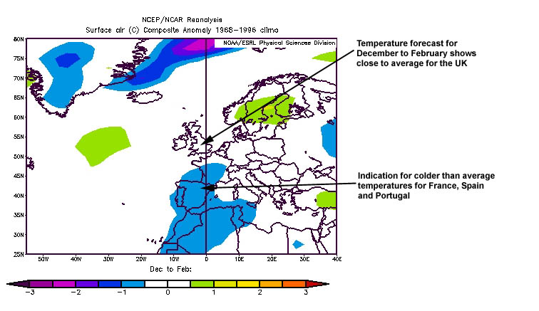
- Temperatures are likely to be close to or slightly below average with the coldest weather (relative to long term averages) centred over France and Iberia, the south-east of the UK closest to this cold. Compared to many winters of the last two decades, this coming winter would probably be regarded as cold although not of the same degree as last year or 2008/9.
Background to this forecast:
- This forecast is based upon the likely influences of La Nina in the Tropical Pacific, atmospheric signals and air temperatures high up in the atmosphere over the Arctic which are seen as key variables, many of which are dissimilar to last winter.
- However, the last twelve months (probably thirteen months after October's data) have seen a negative or cold phase of the North Atlantic Oscillation (a key measure of the difference in pressure between Iceland and the Azores). This is unprecedented since the index was first compiled in 1950 and reflects a reversal in the normal pressure patterns which played a significant part in last winter's weather.
- This forecast based upon an understanding of the dynamical processes involving the world's oceans and atmosphere, the use of historical-based analogues and Netweather.tv's customised seasonal predictive model based upon the Climate Forecast System (National Centre for Environmental Prediction).
Record strength La Nina
- Sea temperatures are widely below normal across much of the Tropical Pacific and these colder waters extend to several hundred metres below the surface in the central and eastern Pacific Ocean. This is characteristic of a La Nina event of medium strength magnitude.
- The pattern of surface winds and cloudiness across the Tropics is very typical of La Nina event and model forecasts continue to suggest the sub-surface anomalously cold waters will work their way to the surface over the next 2-3 months further strengthening La Nina to strong category event, potentially the strongest La Nina of the last 60 years given the large volume of below average waters with temperatures up to six degrees below normal.
- Since July, global weather patterns have been very consistent with La Nina. The European weather patterns associated with La Nina in winter are somewhat variable. Most were dry and mild although there were some colder events in 1955/56 and 1964/5.
Figure 1: Global Sea Surface Temperature Anomalies
Global SST Anomlaies
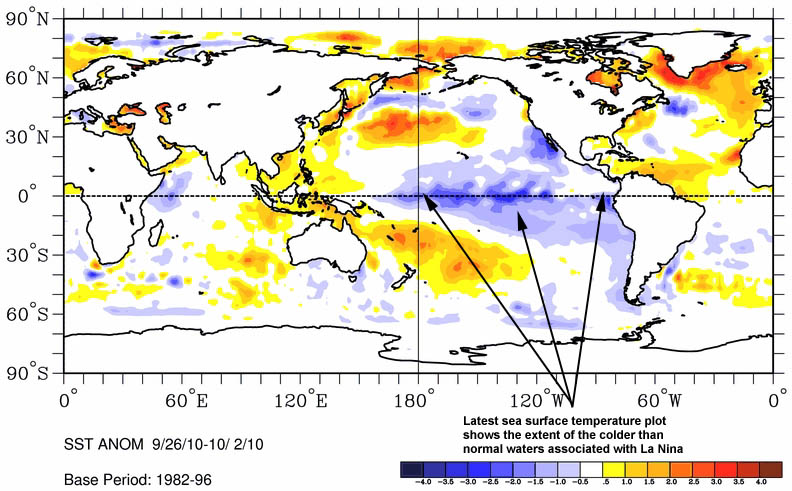
Click to enlarge
- One of the keys to understanding La Ninas and their warm counterpart El Ninos is how the atmospheric variables react to the temperatures of the ocean and whether or not the atmosphere is 'going along' with these changes.
- Most atmospheric variables are also exhibiting extreme La Nina like behaviour. Overall levels of storm activity in the Northern Hemisphere is at a 30 year low despite an active Atlantic hurricane season whilst forward intertia in the atmosphere was the third lowest in 60 years during July and August. The pressure differentials measured in the Southern Hemisphere, which usually indicate the future trends of La Nina have been advertising a strong event in the making.
- Of the strong La Nina events, these atmospheric indicators suggest we are historically much further advanced at this time. Given feedback loops, atmosphere reinforcing La Nina, La Nina reinforcing the atmospheric variables, it is very likely that an exceptionally strong La Nina event will take place this winter with a probable peak in December or early January.
Temperatures in the stratosphere
- One of the key elements of last winter's cold weather was above average temperatures in the upper atmosphere high over the Arctic which promoted blocking highs displacing polar air into Europe.
- This year we expect the combination of low solar activity and a westerly wind over the Tropics to be less conducive to blocking highs with colder than normal atmosphere over the Arctic driving polar westerlies which tend to favour blocking highs further south around the UK.
Seasonal Model Guidance (Climate Forecast System)
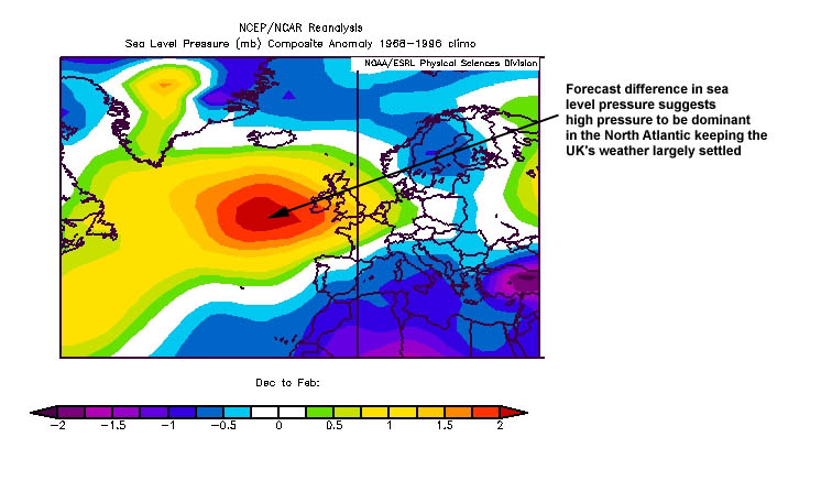
- Model guidance is for high pressure close to or north and west of the UK for the majority of the winter with a slight tendency to shift further away to the west during February.
- Model sees average or slightly colder than average temperatures for the UK, coldest in the south-east and mildest in the north with central Europe slightly below average.
- Model sees rainfall below average.
- Good consistency between model updates and output appears to be consistent with historical analogue guidance adding confidence to forecast.
Winter Forecast details
December
- High pressure likely to be centred to the north-west of the UK with winds from the north-west with northerly interludes.
- Temperatures likely to be below average, the largest departure of the three months compared to long term averages with the coldest temperatures in the south-east.
- Rainfall likely to be much below average.
January
- Large area of high pressure in the central Atlantic gradually edging towards the UK although an unsettled phase likely with potential for snow, particularly in western areas.
- Likely to be cold to start with fog and frost persistent.
- Rainfall below average.
February
- High pressure centred over the UK with a lot of settled weather.
- Temperatures likely to be slightly above average although surface temperatures may be depressed by fog and cloud.
- Rainfall likely to be much below average.
Forecaster: Stewart Rampling for Netweather.tv Issued: 18/10/10
Figure 2: Forecast mean sea level pressure (deviation from long term average)
Sea Level Pressure
Click to enlarge Temperature
Click to enlarge
If you would like to download this forecast as a pdf, please click here.
The standard (updated monthly) long range forecast on Netweather will can be found here (updated later today).
Questions?
If you would like to ask questions about this forecast, please feel free to contact us by clicking here or why not join in the discussion on our community forums.
Both a less technical summary of this forecast and a very in depth detailed version will be available soon. As will a video show in which Stewart will explain the forecast and hopefully answer any questions you may have.
For media or commercial enquiries, please contact us on 01386 576121 or email [email protected]
|
|


