


Election Day turning wet and windy for many, hill snow in the north. Staying unsettled & windy through the weekend and next week, with further hill snow, chilly before turning milder later next week.
More wet and windy weather at times can be expected as we head towards the end of the week and through the weekend, as a succession of low pressure systems roll in off the Atlantic across the UK riding on a strong jet stream. The jet stream will be meandering close to south of Britain over the next few days, so although it will turn milder across the south today, it will be cold in the north. This colder air filtering south across all parts through Friday and into the weekend and it will be cold enough for hill snow across central and northern areas with any precipitation from fronts or showers, perhaps falling to lower levels in the north over the weekend too.
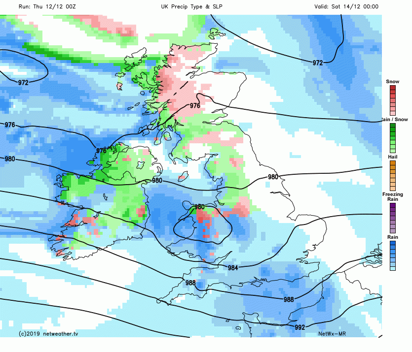
.png)
Low pressure will remain close to the north early next week, so remaining showery and on the chilly side. But as the jet stream buckles north from mid-week and low pressure repositions to the west, so we pull in a milder southerly flow with temperatures rising into double figures, but remaining unsettled, with further rain.
For now, the morning has got off to a cold and, in places, frosty start across the north and east where skies have remained clear overnight, a warning for ice is out across inland parts of Scotland, due to showers overnight possibly washing away salt on roads creating slick surfaces. Though the lowest temperature before dawn was in Kent, where Headcorn had fallen to -3C. So there is a risk of ice on wet surfaces following yesterday’s showers. However, in the west it’s milder, as cloud and rain spreads in from the west.
Cloud and outbreaks of rain already in the west, with hill snow in the north, will continue to spread eastward through the morning, reaching all parts by late morning. Rain will be heaviest and most persistent across the south as a frontal system bringing it moves east ahead of low pressure moving towards the northwest. A swathe of strong southerly winds accompanying the heavy rain as it spreads east across England and Wales. Showers will follow the rain from the west, with outbreaks of rain across eastern England gradually clearing through the afternoon, scattered showers across the west in the afternoon, wintry over higher ground in the north, with snow over 300m. Some brighter spells developing between the showers.
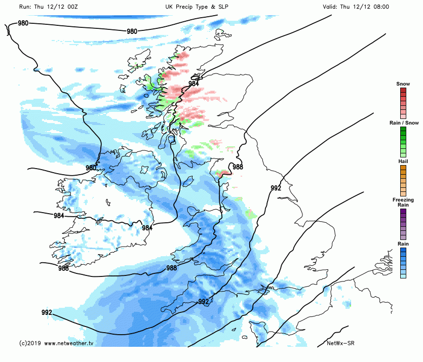
Temperatures struggling across Scotland and NE England, reaching 3-5C at best. Further south it will get progressively milder, with 6-8C for N. Ireland, NW England, north Wales, Midlands and E Anglia. South Wales and southern England reaching 9-11C.
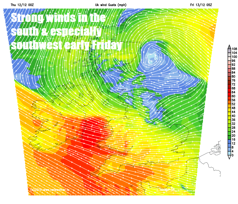
Low pressure will slide southeast across southern Scotland overnight, so although it will push today’s rain away from eastern England, it will spread back in across northeast Scotland overnight, falling as snow over higher ground. Further south, generally cloudy with outbreaks of showery rain spreading southeast, very windy across Wales, southern and western areas of England, with coastal gales.
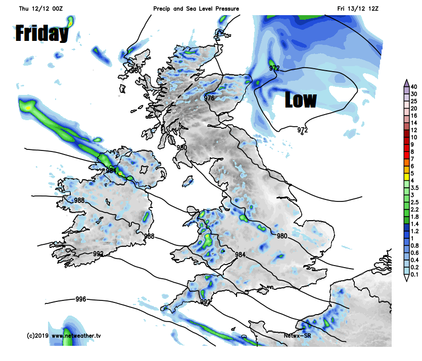
With low pressure slow to clear over the North Sea close to the northeast, a hang back of persistent rain and hill snow affecting NE Scotland in the morning, before clearing into the afternoon. Otherwise Scotland mostly dry and bright with just the odd shower near coasts. Further south, it’s a case of sunshine and showers, most of the shower feeding in across N. Ireland, Wales, NW England and the Midlands, perhaps reaching the southeast, elsewhere mostly dry with just the odd shower. Some snow over the hills from these showers, as it will be chilly day for all, temperatures reaching 5-7C in the north, 7-9C in the south.
There will be low pressure sticking by close to Scotland over the weekend, feeding in showers across much of Scotland and Northern Ireland, most frequent in the north and west. And as it will be cold here, showers falling as snow over higher ground where there will be further accumulations and to lower levels at times too. Highs in Belfast, Glasgow and Edinburgh only reaching 5-6C at best both Saturday and Sunday.
Across England and Wales, a more complicated picture over the weekend, Saturday during daylight looking mostly dry and bright with just the odd shower passing through the south and wintry showers in the northwest. But then Saturday evening a secondary area or wave of low pressure tracks across Wales and northern England, bringing a spell of heavy rain and northern hill snow, perhaps even snow to lower levels across north Wales and northern England for a time. Strong winds developing south of the low, with a spell of gales across southwestern then southern counties overnight. Sunday’s looking like a day of sunshine and showers for England and Wales, showers most frequent across the south and west, falling as snow over northern hills.
Next week remaining unsettled. Chilly early in the week with Monday showery thanks to low pressure close to the north, Tuesday perhaps drier and sunnier - away from western coastal areas where showers are likely. Low pressure repositioning to the west from mid-week, so winds turning more southerly bringing in milder air. Showers or longer spells of rain affecting mostly northern and western areas.


