


The UK's weather is in a rut, as our more traditional Atlantic westerlies try to get themselves re-established.
We are presently in somewhat of a rut, as our more traditional Atlantic westerlies try to get themselves re-established. It's a time of pressure re-organisation that often occurs in late May, and as a result, any changes will be slow. So what you have today you'll probably keep.
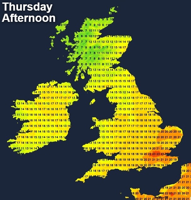
It's a sunny start over much of southern Scotland and North East England, while other parts of northern England mostly West of the Pennines have cloud and patchy light rain. For most of England and Wales though it'll be pleasant enough with some sunshine, although cloud amounts will vary. It'll also be mainly dry, although cloud could build sufficiently across the South West and Dyfed to perhaps produce the odd shower. It'll feel warm in the sunshine in a mostly light West or North Westerly breeze, with temperatures reaching 18 to 21C in most parts and 22 or 23C in the South where you see the best of the sunshine.
Remaining parts of Scotland will see more cloud, With Highland and the North East continuing to see bursts of rain (heavy in places) in a cold and blustery North West wind. As a result, temperatures here will get no higher than 10 to 12C, but over central and western parts of Scotland, 13 to 16C is more likely, in somewhat drier, brighter, less windy conditions. Cloud across Northern Ireland will give some patchy light rain at first mostly over Armagh and Tyrone. But it should be a mainly dry, bright day across the province with sunny intervals - top temperatures here 15 to 17C.
The North and North East of Scotland will see further bursts of rain into the evening and overnight accompanied by a cold North West wind. With cloud across parts of Northern Ireland, South Wales, Cornwall and perhaps Devon also producing the odd shower. For most though it'll be a dry evening and night with skies breaking sufficiently at times to give clear spells. Where skies stay clear and with a West or North Westerly breeze mostly light, a few mist or fog patches will form towards dawn in rural areas, but these will be short-lived. Although perhaps turning a little chilly in some rural locations it's not expected to be a cold night, with minimum temperatures mostly in the range 6 to 11C.
Tomorrow will be a similar day in most parts with some sunshine, but the distribution of cloud cover will be different. There's also a somewhat more significant risk of catching a shower across Northern Ireland, Wales and in the South later. But if you see one elsewhere, you'll be unlucky, with the emphasis remaining on mainly dry conditions. Meanwhile Highland and North and North East of Scotland see further showers, that'll probably become more confined to the Northern Isles and districts around the Moray Firth through the day.
A mostly light or moderate West or North West wind could still be quite fresh across Orkney and Shetland for a while in probably a somewhat cooler day in most parts. The afternoon should be warm over much of England and Wales though with temperatures reaching 17 to 19C quite widely and 20 to 22C in the sunnier spots across the South. Across Northern Ireland and Scotland however, 14 to 16C will be nearer the mark with the Northern Isles and Moray getting no higher than 11 to 13C.
The far North East of Scotland and perhaps southern England see a scattering of showers into the evening, many of which should fade later. This'll leave a dry night in most parts allowing skies to break and with a West to North Westerly breeze mostly light. A few short-lived mist or fog patches could form again in rural areas towards dawn. In a relatively mild night though temperatures generally shouldn't fall below 7 to 11C.
The extended weekend shouldn't be a washout by any means, but it'll often be fair rather than fine. The trend will be for the weather to turn cooler and more unsettled, with a cold front bringing some showers from the West, particularly on Sunday.


