


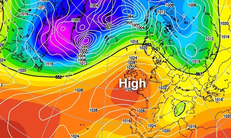
With an anticyclone remaining in charge the weather is going to stay mainly dry with temperatures rising into the second half of the week.
With an anticyclone remaining in charge for at least the remainder of this week it's going to stay mainly dry. The high pressure is anchored just to the South West, however, and this is allowing weak Atlantic systems to affect mostly the North and North West of Scotland.
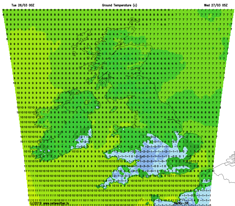
It's a cold start in the South and across much of the Midlands and South Wales, with temperatures as low as -4C in rural parts of Oxfordshire first thing. Morning sunshine, however, will soon lift temperatures, although with patchy cloud forming through the day. Across the remainder of the country, there'll also be some sunshine, but it won't be as sunny as yesterday across England and Wales, with more in the way of cloud. Nevertheless, it'll continue to be dry and quite and pleasant with sunny intervals, the only exception being the North and West of Scotland. Here the cloud is thick enough to give local light showers, with a meandering front further North giving heavier bursts of rain at times across parts of Highland and the Northern Isles.
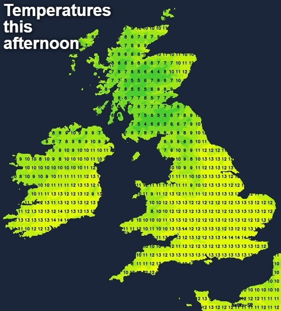
A mostly light or moderate North West or Westerly wind will be fresh across the North of Scotland. This'll feel chilly at first especially in the South, but in a typical early spring day, top temperatures of 9 to 11C in the North and 12 to 14C in the South will be close to if not somewhat above the late March normal.
Little change is expected after dark with cloud amounts continuing to vary. The West of Scotland sees further isolated light showers, while Highland, Orkney and Shetland remain wet with more outbreaks of rain in a fresh South West wind. Over the remainder of the country, it stays dry with skies breaking to give clear spells, especially where you have shelter from a lighter Westerly breeze. It'll turn misty in the West, with a few fog patches forming towards dawn, mostly over rural parts of central southern England and South Wales where skies remain clear. Here it'll turn cold again with a ground frost in places as temperatures fall close to freezing in the coldest spots. For most though you'll avoid a frost, with 4 to 7C nearer the mark.
It remains much the same on Wednesday, with high pressure just to the South of the country remaining the dominant feature. Atlantic frontal systems continue to pester the far North and North West of Scotland bringing further showers in moderate or fresh South West wind, while the bulk of the country remains fine and dry. Cloud amounts continue to vary however with the best of the sunshine once early fog patches have cleared, mostly where you have shelter from a light or moderate West or South Westerly breeze. After the chilly start in places, it'll be pleasantly mild by the afternoon with top temperatures 10 to 12C in the North and 13 to 15C further South.
Weak Atlantic systems continue to brush the North and West of Scotland into the evening and overnight making it more cloudy here at times with a few showers. Elsewhere though it stays dry, with skies breaking at times particularly over England and Wales where a West or South Westerly breeze will be light. This'll allow mist and patchy fog to form again in some rural areas where it'll turn chilly, with a ground frost in places once more. The minimum temperature in the coldest spots will be 0 to 2C, but in the North and West and where you keep patchy cloud, the thermometer shouldn't fall below 5 to 7C.


