An east-west split today, with rain in the west and sunshine in the east, we could reach 23C in the southeast. Mild in the week ahead, warm in the south, rain on Monday, mid-week and Friday.
After some rather cool and autumnal weather this month so far, especially at night, the weekend and also early next week offers something more akin to late summer with temperatures reaching the low twenties in the south. Saturday saw the highest temperature of 20.7C at Pershore in Worcestershire and today we could see the mercury climb to 23C in a few places with winds lighter and the southerly flow coming from a warm near continent.
Although it will generally stay warmer than of late this coming week, we will some rain at times, as Atlantic fronts move in. Monday will see a little rain at first, Tuesday and Wednesday mostly dry, rain Wednesday night clearing Thursday morning to drier and brighter conditions before rain returns from the west on Friday.
For now, something of an east-west split today, with western areas seeing cloud and rain while eastern areas enjoy some sunshine. For a change, it’s not too cold a start this morning, with most places widely starting the day in double figures.
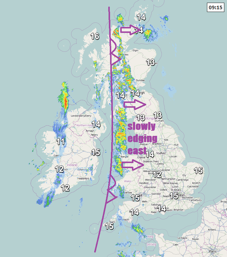
A slow-moving front that moved in from the west overnight will bring cloudier skies and a band of rain across western Scotland, Isle of Man, Wales, Cornwall and Devon this morning. Cloudier skies feeding in across NW England, east Wales and SW England too, but dry for now here. But for eastern Scotland, central, southern and eastern England, it will be a mostly sunny morning after any early mist or fog patches clear.
It will tend to cloud over from the west through later this morning across eastern Scotland, northeast England, the Midlands and central southern England with some patchy rain arriving in the afternoon in the west of these areas. Rain continuing across the west, locally heavy over hillier parts. But for much of eastern England it will stay dry and sunny throughout the day. And we should see some drier and sunnier conditions arrive across N. Ireland later this afternoon, though with a risk of an odd shower.
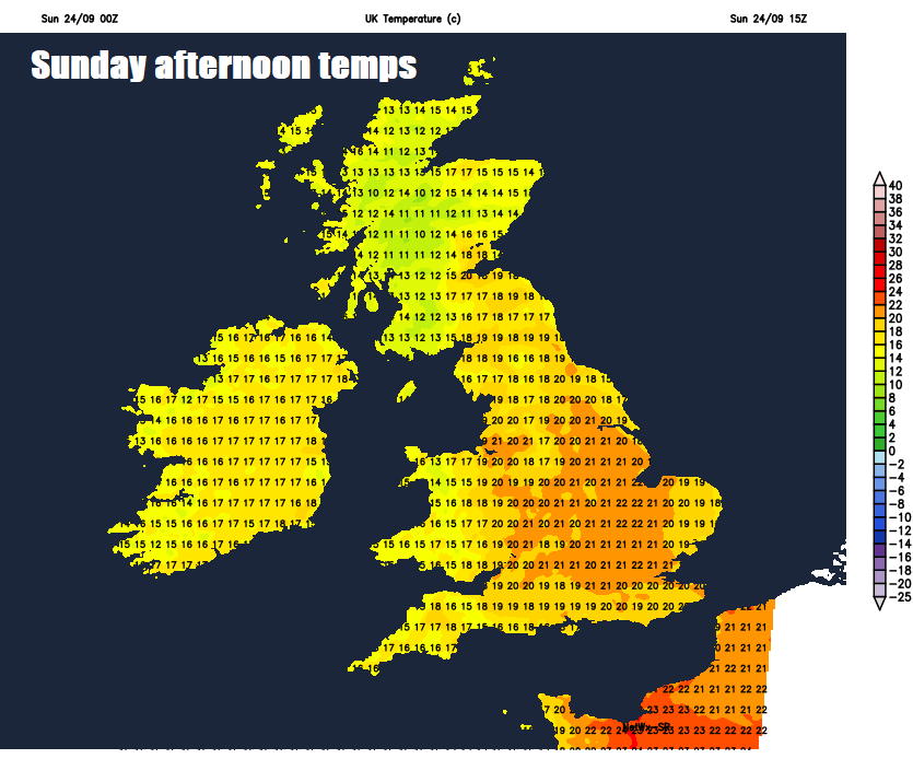
Quite a warm day across eastern counties of England with the sunshine and light southerly winds, temperatures reaching 17-20c widely, perhaps 22-23C across SE England. Under the cloud and rain in the west: 16-18C across SW England, Wales and NW England; 14-16C across western Scotland and N. Ireland.
The rain turning heavier this evening and overnight as it edges slowly east across Scotland, northern England, The Midlands and central southern England, perhaps not reaching most of East Anglia and far SE of England until dawn. Drier, clearer but cooler conditions spreading in across the far west, turning chilly by dawn across N. Ireland – where we could also see some fog patches forming.
A grey and murky start for many on Monday morning, foggy across N. Ireland. Outbreaks of rain or drizzle across eastern Scotland, northern, central and eastern England during the morning tending to die out by early afternoon. Then turning drier with some warm sunshine across eastern areas, but remaining cloudier across parts of Scotland, NW England and Wales, with the odd patch of drizzle over the hills, N. Ireland seeing some sunshine after the foggy start. Temperatures reaching 14-17C in the north, 17-20C in the south, perhaps a degree or two higher in a few spots in the southeast.
The rest of the week is looking generally fairly quiet up until Thursday, with dry and bright conditions on Tuesday and Wednesday, warm in the sunshine in the south, temperatures will reach the low twenties towards the southeast. Tuesday staying mostly dry and sunny after perhaps a foggy start, though a few showers possible, though most will miss them. Wednesday again sunny for many to start, though tending to cloud over in the west, with outbreaks of rain arriving here in the evening.
Outbreaks of rain spreading east across all parts Wednesday night, clearing eastern areas during the morning to leave a mostly dry and bright or sunny day, warm towards the southeast, probably clouding over in the west in the evening, as rain arrives across Ireland.
Friday, for now, is looking breezy or windy, with outbreaks of rain spreading east across all parts, followed by brighter but showery conditions. Thereafter into the following weekend it looks like we could enter a more unsettled phase, with Atlantic low pressure systems rolling in and dominating, bringing spells of wind and rain at times.