


It doesn't compare to the goings on across the Atlantic currently, but the UK is into a run of very unsettled weather with more rain and wind to come.
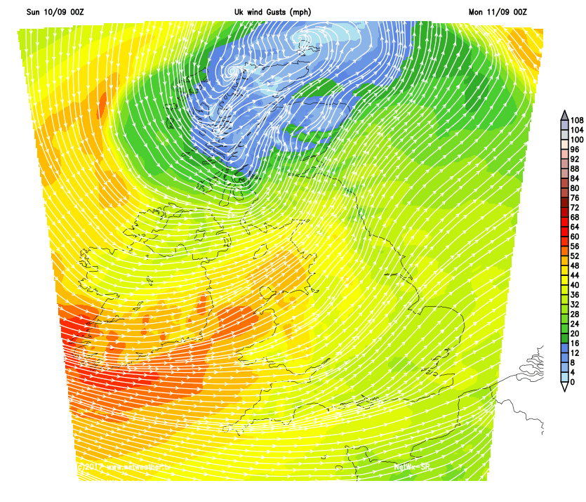
The two category 4 hurricanes currently battering Florida and the Caribbean continue to grab the headlines but although not on the same scale, it's very unsettled here too. Further showers or longer spells rain are expected in the next few days and it'll also be rather cool and windy at times, with gales, locally severe in the North and West.
Some eastern areas are waking to a little sunshine this morning, but it'll soon cloud over as Atlantic systems move in from the West. We already have some patchy rain in the West, over Wales and across Scotland, where there are heavier bursts. This'll spread East, although much of the day across East Anglia and the South East should be dry. Patchy rain across Northern Ireland will soon be followed by blustery showers some heavy in the North and West, this spreading to most parts by the end of the day.
Light winds in the East at first will freshen from the South West making it quite blustery later, the exception probably being the northern half of Scotland where you'll be closer to a depression moving in from the West. Across England and Wales though, the wind will become fresh or strong with gales in the West later. This coupled with the unsettled conditions will make it on the cool side for the time of year, with top temperatures only 13 to 15C in the North and 16 to 18C in the South.
It'll remain very unsettled and windy during the evening and overnight, with blustery showers circulating around a quite deep depression centred close to the North of Scotland. There'll be some heavy bursts of showery rain especially over Scotland, Northern Ireland and in the North and West. Over more sheltered parts of central and eastern England, the showers may be more scattered allowing skies to break at times, but drier intervals shouldn't be relied upon.
Northern Scotland close to the centre of a depression will have lighter winds, but with gusty conditions in showers. Elsewhere, a South West or West wind will be fresh or strong and there'll be gales in the West and South West, with gusts to severe gale force in exposed areas and in heavier more squally showers. It may also feel slightly chilly in the wind, but temperatures shouldn't fall below 8 to 11C.
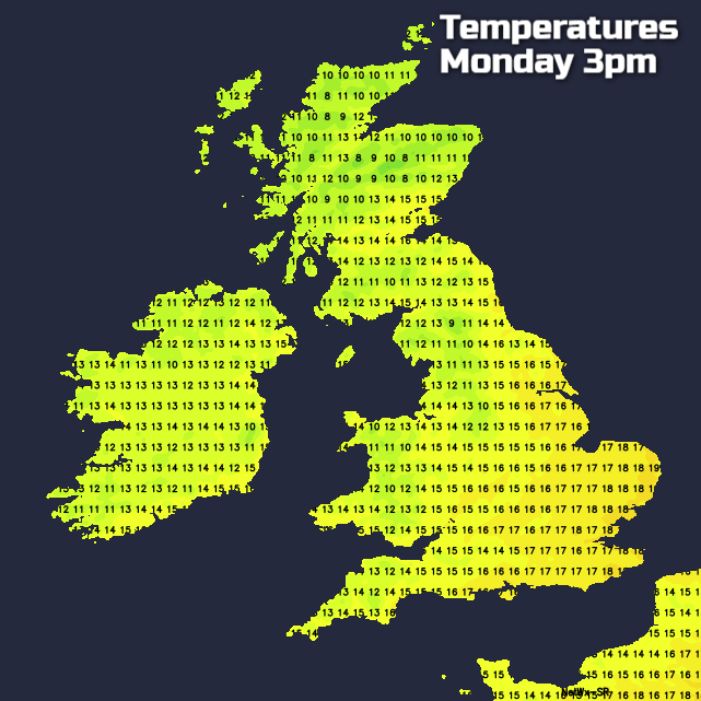
Monday sees further blustery showers most frequent in the North and West, with some heavy, squally, lengthy ones across Scotland, Northern Ireland and in the North and West. In the East, the showers may be more scattered allowing sunny intervals but even here, some of the showers will be heavy giving local hail and perhaps thunder. A blustery West or North West wind will remain fresh or strong, with further gales likely locally severe in the West at first. It'll be rather cool, with top temperatures just 12 to 14C in the North and 15 to 17C in the South.
More blustery showers seem likely into the evening some heavy but after dark, they'll become less frequent. Sheltered eastern areas could see skies breaking enough to give clear intervals, but still with the risk of catching a further passing shower. A West or North West wind will decrease a little but remain blustery especially in showers. It'll be a chilly night, with temperatures falling to around 6 to 8C in sheltered rural areas and 9 to 11C in towns and cities.


