29C yesterday, hottest day of Aug 2017, but we'll be lucky to reach 19C today. You'll notice more of a chill in the mornings with a lot of fine, bright weather to come and a scattering of showers, once the SE rain clears
29.3C in Kent yesterday as the Bank holiday heat held on for the SE. Today London and the SE will only see 16 or 17C, everywhere is now in the fresher air. It’s actually quite cool for northern Britain with temperatures down to 5 or 6C, even 2C in the mountains.
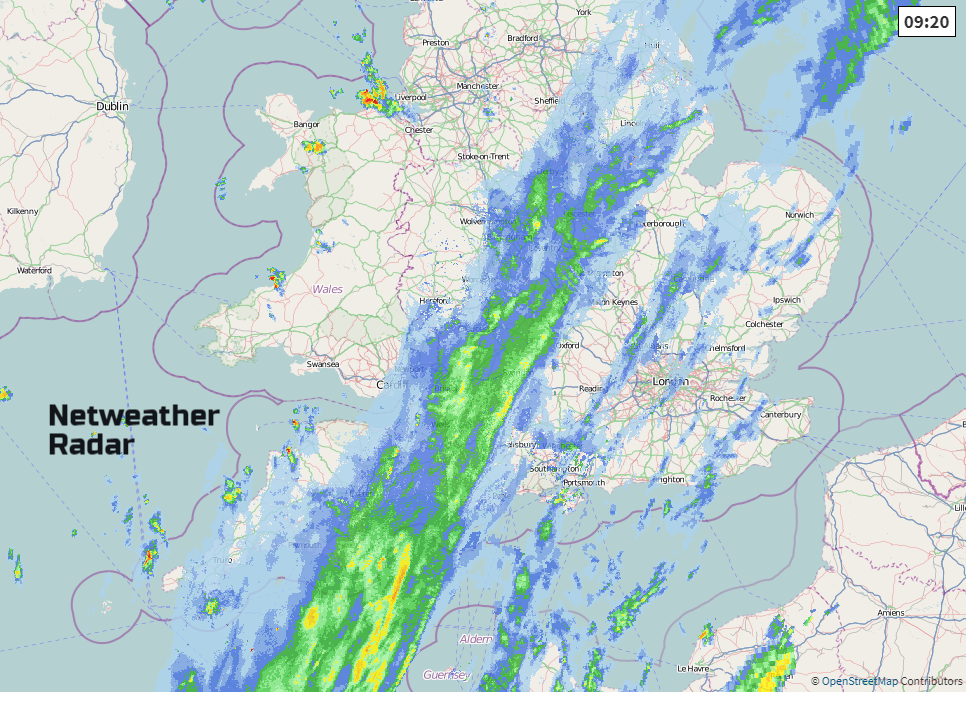
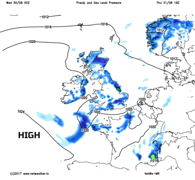
There are two fronts across the UK, the surface cold front which is across most of England now, just the far SE still holding onto some warmer air ahead of it. If you switch to the Europe setting on the Netweather Extra radar, you can see bright echoes over the Amsterdam and the Low countries, from thundery rain as the heat remains over Europe and an upper cold front, producing more rain. We have a band of rain from Lincolnshire down to Dorset and more cloud and patchy light rain over SE Britain. There is also a brisk north wind which stays around the Thames estuary and for Kent, backing slightly today. The frontal bands nudge SE wards today but will take their time over the Home Counties, London and East Anglia this afternoon so becoming wet and grey here and still feeling cool.
Northern England and Wales are emerging from the frontal cloud, and there will be more sunshine and bright skies as the day goes on, brightening up across the Midlands and SW England too. Northern Ireland and Scotland have started the day with fine sunshine and will continue with a lot of bright weather but just a scattering of showers developing. These will mainly be for western Scotland and the NW of Northern Ireland this morning but spreading further east during the day, especially over Northern Ireland and towards Grampian with some hefty downpours likely. Other brighter spots could also see the odd shower, the middle of this week is turning more showery.
Temperatures today 15 to 18C, maybe the odd 19C in a sheltered, sunny eastern spot and mostly light to moderate west winds.
Cool and clear overnight, as we head towards meteorological autumn.
Thursday will have a lot of fine, bright even sunny weather but with more scattered showers and a higher chance of a hefty, even thundery downpour. Eastern England will feel warmer than today up to 19 or 20C, and there will be light winds everywhere. Pressure is bringing to rise, building in from the SW. Later in the day the showers fade, last longest over eastern Britain but well scattered by then.
Overall Friday is looking fine and bright with many areas having a dry and sunny day. However, there will still be a few hefty downpours over England, very hit and miss but still not a completely dry forecast. With a light north wind to start the day, there could be mist and patchy fog about, there is that nip in the air, and it will have been clear overnight, with the same for early Saturday. There may even be a touch of frost in the north. There could be a cluster of heavy thundery showers clipping the far SE on Friday night; we’ll see if the high pressure manages to squash them away.
By Saturday, the winds will be from the south and it will feel warmer by day. For Britain, it will be fine and sunny again but Northern Ireland will be windier and could see cloud increasing from the west later.
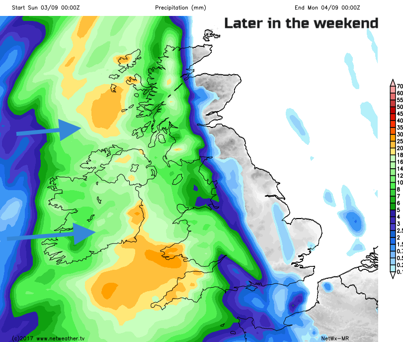
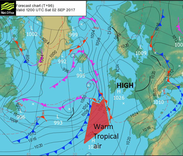
There are uncertainties about the rest of the weekend. It could be that the high pressure holds on and there is more fine weather, with what is turning out to look like a good spell of weather over the weekend/for the end of the school holidays. However, lurking out in the Atlantic is a low pressure which will have links to major low pressure currently moving near to NE US and the far east of Canada. This was being monitored by the National Hurricane Centre yesterday when it was off the coast of the Carolinas to see if it would form into a Tropical Storm as Irma, but it hasn’t. It still is bringing a lot of heavy rain and strong winds and will add its energy and tropical air into developments across the pond. This is where the weekend uncertainty comes for us, whether heavy rain will move inform the west over Ireland, to Britain during Sunday. It looks like we will get warmer more humid air but all of this has got to come up against the high pressure.
Outlook
Thursday is the last day of meteorological summer. For us weather folk autumn starts on the 1st of September and runs until the end of November, it helps with the climate data. Nature will continue to do its own thing no doubt. For a look ahead, as the children go back to school, here’s the Netweather monthly outlook.
New Wind-proof Queensferry Crossing opens today; the weather is looking kind for the ceremonies this weekend.