Harvey, a category 2 hurricane, will make landfall across Texas late on Friday, perhaps as a cat. 3 hurricane. Catastrophic flooding the mean threat.
*UPDATED FRIDAY AFTERNOON 25TH AUG*
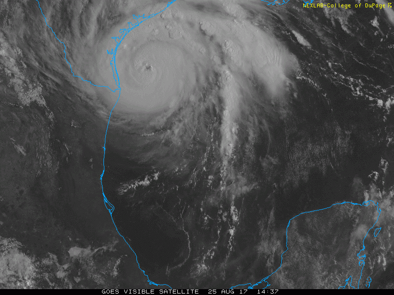
Harvey has intensified into a powerful Category 2 Hurricane this morning, with a minimum central pressure of 950mb and sustained winds of 110mph and is approaching the Texas coastline.
Hurricane Harvey is expected to make landfall along the Texas coast as a category 3 hurricane Friday night local time, Saturday morning UK time. It will be the first major hurricane to hit the U.S. mainland in 12 years - since Hurricane Wilma struck Florida in 2005.
As the hurricane interacts with the Texas coast, it is expected to slow or even stop its northwestward progress, as the steering currents produced by high pressure system over the eastern Gulf of Mexico weaken inland over Texas.
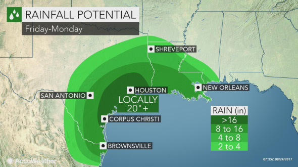
The slowing of Harvey will bring prolonged heavy to extreme rainfall across SE Texas later today and through the weekend and possibly into early next week, with as much as 35 inches falling towards the SE Texas coast, as the storm meanders on and off the coast. If it moves back over the warm sea, it may re-intensify too. So there is potential for catastrophic flooding, including large populated areas such as Houston, Corpus Christi and Galveston.
Here are the National Hurricane Center Key Messages:
------------------------------------------------------------------------------------------------------------------------------------------------------------------------------------------------------
*PREVIOUS BLOG - THURSDAY 24TH AUG 2017*
The remnants of what was once tropical storm Harvey … which previously tracked west across the Lesser Antilles, Caribbean Sea and Mexico’s Yucatan Peninsula …has redeveloped into Tropical Storm Harvey once again over the western Gulf of Mexico and threatens to quickly deepen into a major Hurricane.
Track of Harvey so far ...
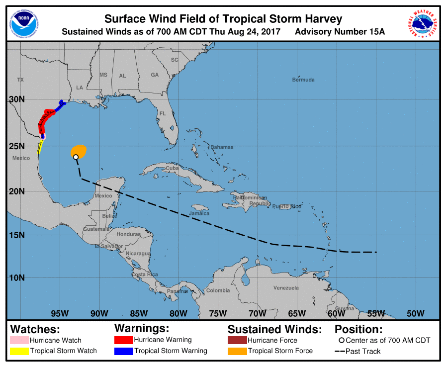
The U.S. National Hurricane Center designated Harvey a tropical depression on Wednesday over the Bay of Campeche before upgrading Harvey into a tropical storm this morning which will track northwestward towards the Gulf coast of Texas, becoming a hurricane tonight. Weather models have converged on the idea of Harvey making landfall along the Texas coast on Friday, though where it makes landfall is still unclear.

06z GFS track for Harvey (credit: tropicaltidbits.com)

Harvey will continue to strengthen as it heads northwest and is expected to become a Hurricane before landfall somewhere along the Texas coast Friday evening or night local time, latest NHC suggests category 3 on landfall. The main concern was initially for inland flooding which could be serious enough to risk lives and property. But now Harvey is forecast to rapidly intensify and make landfall as a cat. 3 hurricane, when earlier forecasts suggested cat. 1, then hurricane force winds reaching sustained 115mph, with higher gusts, will bring wind damage and disruption along with dangerous surf and a major storm surge along the coast.
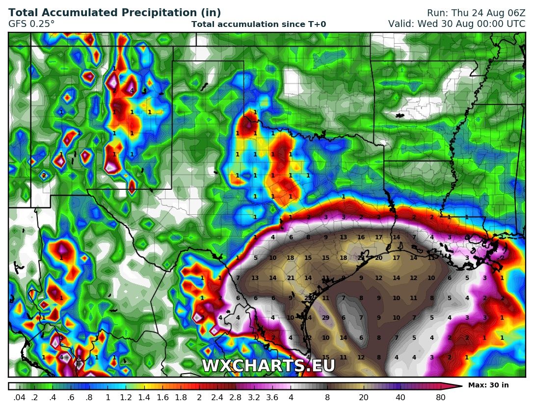
The worry is that Harvey may meander or stall over SE Texas. The storm may even make multiple landfalls, by moving on and off the Texas coast, but for now there is still model uncertainty over exact track – especially given a non-tropical system over the U.S. may block Harvey’s landfall. Some of the high rainfall totals forecasts by model runs that stall Harvey are quite eye-opening, with some areas of SE Texas forecast a heavy rainfall event from Friday until Tuesday and likely to receive 10-20 inches in places, with a few areas around Houston and the coast nearby perhaps in excess of 20 inches! This could have tremendous life-threatening and economic impacts.
Total accumulated rainfall ending midnight next Tuesday from 06z GFS run (credit: wxcharts.eu)
Coastal impacts and rainfall potential (credit: accuweather.com)
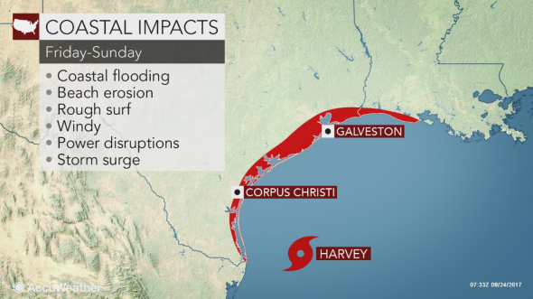
In additions to rough surf, storm surge, high winds and the main threat of inland flooding, Harvey may also produce tornadoes, as it often the case, on the north and east side of the storm.
In readiness of the likelihood of Harvey making Texas Landfall, a Storm Surge Warning is now effect for the coast of Texas from Port Mansfield to San Luis Pass, TX. A Hurricane Watch has been issued for the coast of Texas from Port Mansfield to Matagorda, TX. A Tropical Storm Watch has been issued for the coast of Texas from N of Matagorda to High Island, TX.
With quite an active period coming up with tropical disturbances over the Atlantic at the moment, there is potential, other than Harvey, for a new tropical storm to develop off the coast of Florida and maybe further disturbances moving west out of western Africa developing into storms too.