Further low pressure systems set to maintain unsettled weather, along with some particularly depressed temperatures for early August.
Issued at 1500BST on Tue 1st Aug based on Tue 1st Aug 00Z Model Runs
Key Points
Discussion:
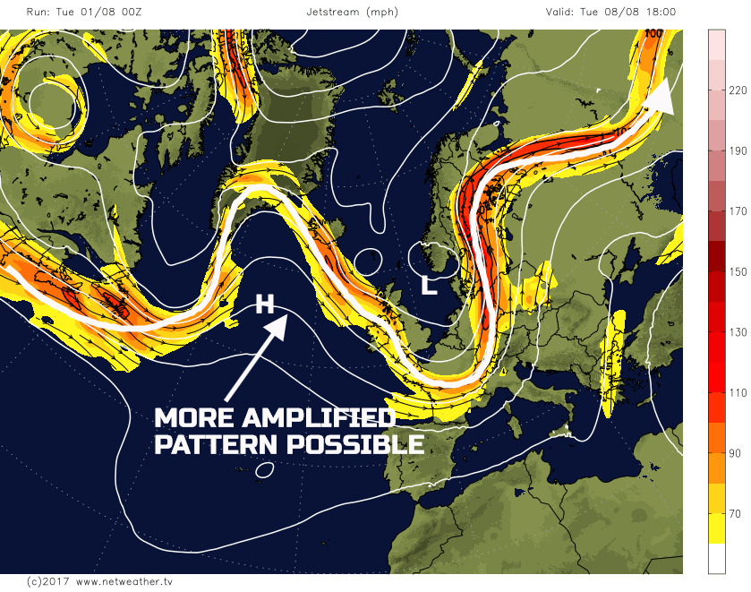
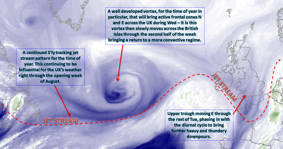
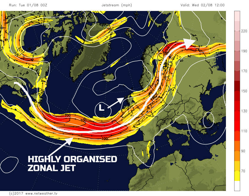
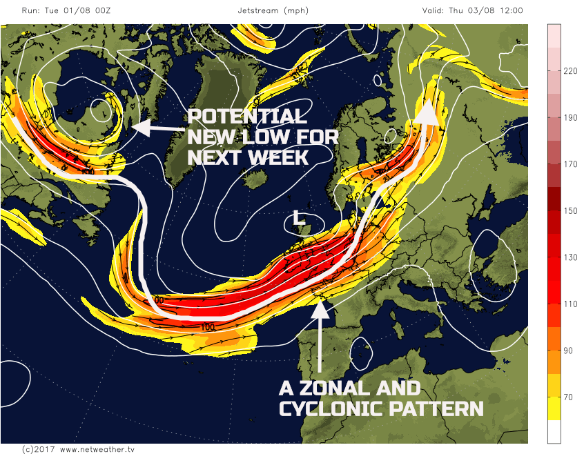
Wed 2nd Aug: Overnight and through into Wednesday and a mature vortex in association with a surface low pressure situated on the cold side of the jet, will be approaching the UK from the SW. A well defined and zonal jet stream pattern, for the time of year, will be evidence originating over the far NE of the USA and ending across Scandinavia. This level of organisation is something which is often present through the autumn and winter period across the northern hemisphere.
The frontal zones associated with the surface low pressure moving N and E through the day are complicated. An overall lack of forcing across parts of the N and W of the UK means that the frontal precipitation is likely to be mainly light or moderate in intensity. However, across parts of England and Wales there is some evidence that the frontal system will split forward, and during the afternoon and evening, the associated trough will over-run and create a more convective regime. There is, as a result, some evidence of shallow moist zone (SMZ) conditions across parts of England and Wales. As a result, an awkward mix of both dynamic and convective precipitation will develop through the day, but with some locally heavy rain developing across more central and southern areas of England. There is good model agreement from the HRES model, along with the GM’s too for this evolution, but the finer details may well still change and affect the precipitation intensity and distribution.
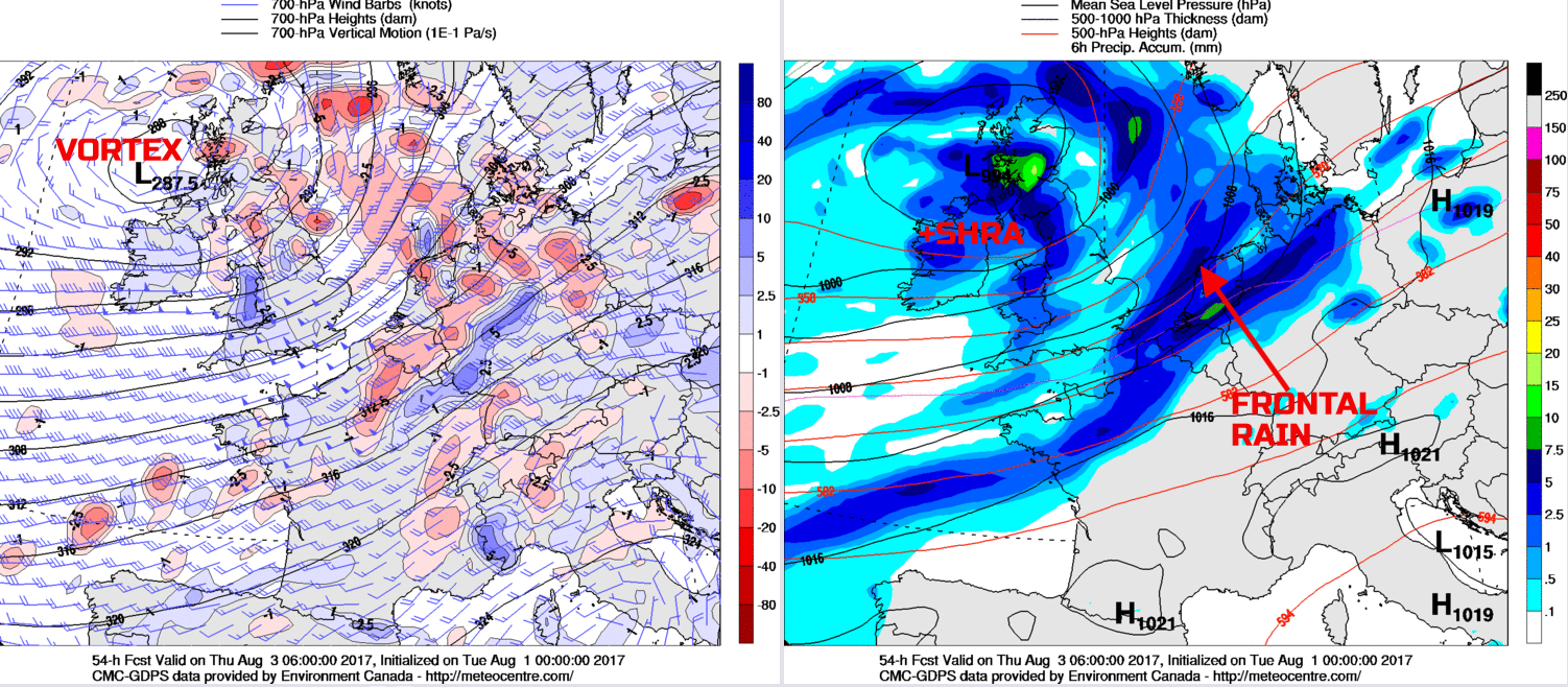
However, using the 00Z GEM model, as a guide, there is evidence of a more pronounced region of vorticity, and associated heavier precipitation, potentially moving into some S and SE areas of England through the late afternoon and into the evening. This development has the potential to bring some locally large rainfall totals in quite a short space of time, given that some of this precipitation will be convective and also fall within a relatively high WBPT environment.
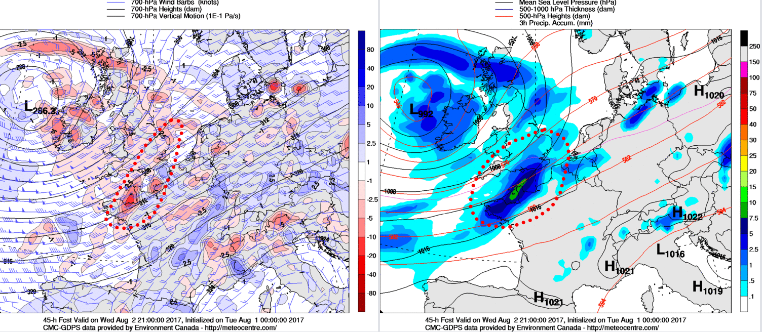
Following from the W will be a steady drop in thicknesses as the main WBPT plume, associated with the frontal zones, clears away to the E. As a result, late on Wednesday and into the overnight period a more straightforward convective regime will become established from the W.
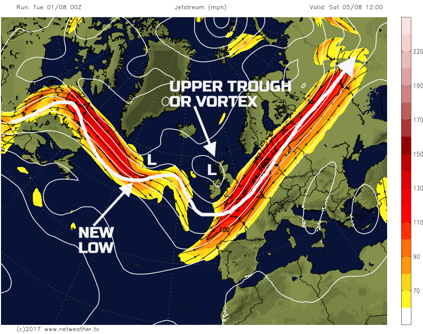
Thu 3rd Aug: On Thursday and the upper vortex and associated surface low pressure will be moving across the UK, slowly, through the day. The main frontal zones, by this point, will be well clear to the E of the British Isles and it will be a convective regime that will be dominant in many areas. The main jet stream, of which will be associated with perhaps >150mph winds, will be passing directly over the UK as a broad cyclonic pattern dominates the N Atlantic and particularly the NW of Europe.
The weather across many areas of the UK through the day will be a mixture of sunshine and showers. The showers will be most frequent to the N of the main jet stream, where the coldest mid and upper-level temperatures will be. As a result, some heavy and perhaps thundery showers may well develop across Scotland, Ireland and N England through the day. Beneath the main surface low pressure, the showers that develop could be particularly slow moving across Scotland, bringing some locally large rainfall totals. Equally, there is some evidence that occlusion debris may well still be circulating the primary surface low pressure and this may well organise the showers into longer spells of rain at times. Fewer showers are, however, expected across S England, but even here some can’t be ruled out, and all areas will see a blustery and increasingly fresh day.
The 00Z GEM, UKMO, ECMWF and the GFS GM’s are all in good agreement regarding this synoptic setup through the day. The 00Z GEM is a useful guide as we move into the Thursday, with the more dynamic frontal precipitation clearing E, while the convective regime develops behind.
Fri 4th Aug: The working week ends with the main surface low pressure and upper vortex beginning to drift away to the NE. Again, there is a good model agreement between the GEM, UKMO, ECMWF, GFS and the associated ENS, regarding this pattern. While the local and regional detail of shower distribution is somewhat uncertain, the overall confidence in the forecast is high. The convective regime, across many areas, will continue through the course of Friday. Once again it is likely to be more northern areas of the British Isles that experiences the heaviest and most frequent showers, with local downpours and thunderstorms possible. However, importantly, as the surface low pressure begins to pull away there will be a marked change in wind direction. Through the day winds will become more W or NW’ly. As a result showers, compared with most of the week, will track from an NW to SE direction, bringing a risk of showers to some areas that may well escape from them during previous days.
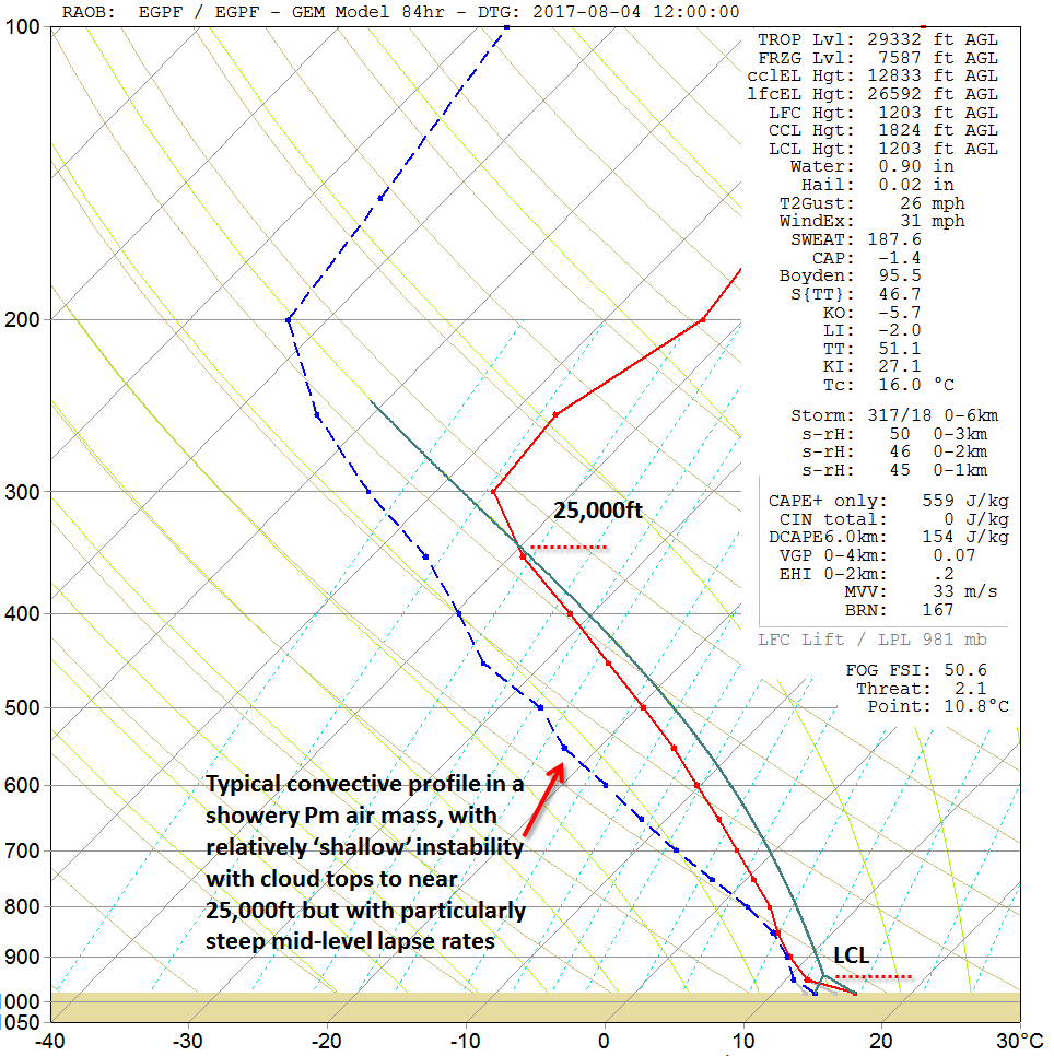
The forecast sounding for Glasgow, towards noon on Friday, highlights the air mass that will dominate across many N areas during the day. The forecast profile wouldn’t look out of place in spring or autumn, particularly regarding the relatively low surface temperatures and the particularly steep mid-level lapse rates. As a result of some notable, Pm-type convective developments.
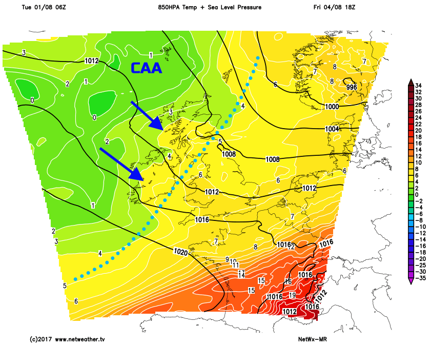
The advection of some quite cold air, for the time of year, down from the NW is exampled well on our MR model, with regards to 850mb temperatures. At the moment, by late Friday, 850mb temperatures will only be around 0C or +1C to the NW of the UK. As a result, this highlights a distinctly chilly air mass for the time of year of which will continue to move down into the UK into the coming weekend.
Sat 5th and Sun 6th Aug: So, we move into the coming weekend and, overall, the pattern across the British Isles will remain cyclonic. An upper trough, or perhaps a vortex, is currently forecast to move across the UK during the day on Saturday and will maintain an atmospheric environment that is very similar to that of Friday. The air mass over the UK will have Pm origins, of which will lead to some particularly depressed temperatures for early August as the day progresses. Downstream, to the W or NW of the UK, is likely to be a surface low pressure and this is set to move into the UK, from the W, towards the end of the weekend. There is some model divergence regarding this feature. However, it may well replace a more convective regime with something more dynamic, regarding rainfall, as frontal systems approach later on.
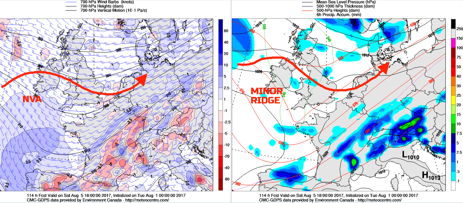
The weather on Saturday will see another day of sunshine and showers. The details of which, at this stage, are unknown. However, with a set of similar forecast soundings on Saturday than when compared with Friday, then some further locally heavy showers are possible. The showers perhaps easing through the second half of the day though as profiles ‘dry out’, as a minor and transient ridge builds into the UK from the W, ahead of this next system. The 00Z GEM model an excellent guide, as things stand.
As we continue to progress through into Sunday and there may well then be a brief period of somewhat drier and brighter conditions ahead of this next system. The timing of this feature may well change, but the 00Z UKMO, ECMWF, GFS and GEM are all in relatively good agreement to bring in a surface low pressure, from the W or NW, by the end of Sunday. As a result, frontal precipitation may well arrive from the W late in the weekend, perhaps especially so in W Scotland, Ireland, Wales and SW England. However, for more central and eastern areas of England and Scotland then Sunday afternoon may well produce a reasonable period of weather, with some bright or sunny spells ahead of this next system.
Medium and Longer Term 7th Aug onwards:
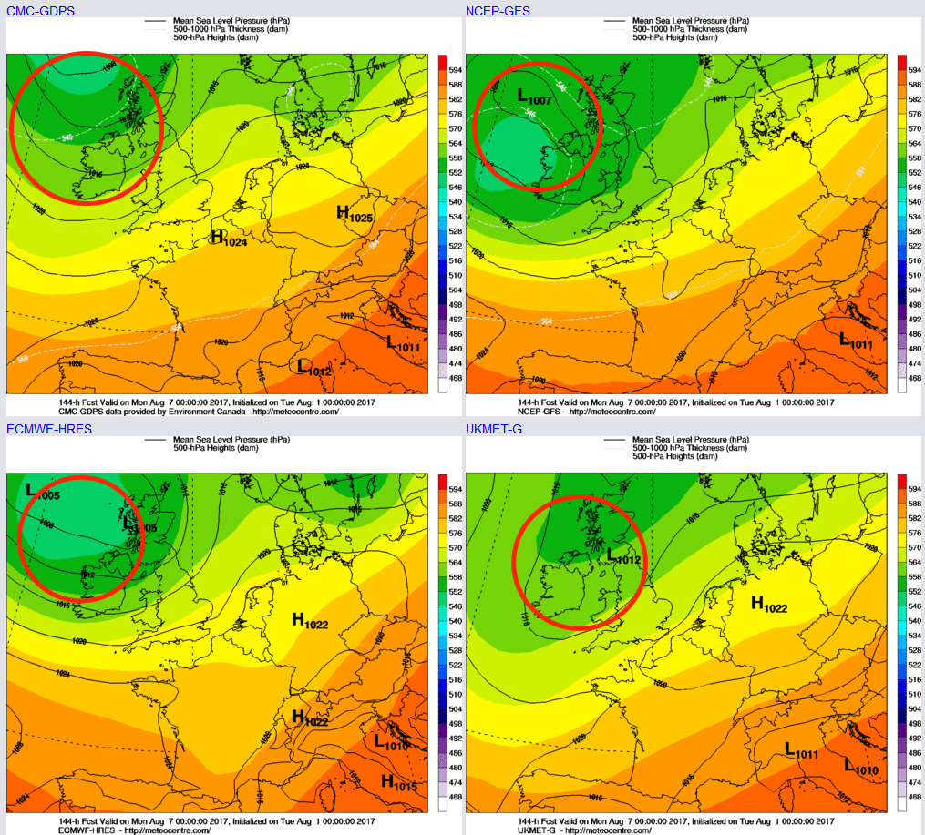
Looking ahead beyond the opening week of August and there is some model divergence in evidence. What may well become a feature by this point as well are the remnants of Tropical Storm Emily, currently over parts of the SE USA. It is that time of year, through August and beyond, that remnant tropical features can ‘alter’ the N Atlantic pattern quite well. Sometimes this alteration is for the better, sometimes for the worse. However, an unsettled start to next week will likely be in evidence, as the surface low pressure, and upper trough or vortex is moving E across most areas. However, beyond the middle of the week, from late Tuesday onwards, there is some evidence of a more meridional flow developing to the jet stream. As a result, this may mean a more ridge pattern may move into the UK towards the 9th, 10th and 11th, from the W, signalling a more settled period of weather.