With blustery winds, strong sunshine and hefty showers, there will be some okay weather about and warmth but you will just have to watch out for the downpours. Suncream, jumpers and raincoats to hand.
It’s just not reliable, our summer weather. You can plan something outdoors but just have to worry, have to think of a backup, keep a wet weather contingency. Yesterday for many eastern areas there was a lot of fine, sunny weather but still with darkening skies and the odd shower. Western Britain and Northern Ireland saw plenty of showers with heavy downpours and thunder with lightning. The convective activity was enough that there were reports of tornado damage in Wigan. No “mini” please!
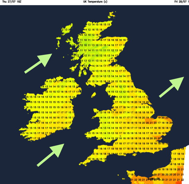
Even though the sun is still very strong, the top temperature was 22C at Heathrow (72F). This air coming in off the Atlantic isn’t hot or humid, but it does bring downpours.
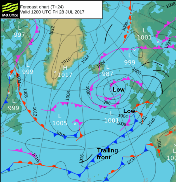
We still have low pressure away to the NW, which will continue to drive in more showers. Low pressures recently have been very slow, hence the unsettled weekend and more rain this week. Our main steady low in the NW will still be there through Monday. However, a cheeky little new low will have had enough of waiting and will nip around the bottom of the NW low, bringing rain today. That movement will be quite quick , but it will leave a trailing front through the English Channel and so the clearance isn’t straight forward.
It will be blustery today with a fresh SW wind, strong at times around the coasts and through the Irish Sea. Temperatures will rise into the low 20s Celsius once more, feeling warm in the strong sunshine but cooler when it clouds over/rains and the wind blows.
Already the Netweather Radar is speckled with showers blowing in from the west. There are two new Netweather apps (android version is ready, iOS wanting testers) to watch the rain and showers over the UK. Again, today will see favoured areas staying dry and bright but other parts getting shower after shower. The rain in the SW will turn more persistent as the cheeky low edges in.
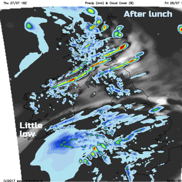
Wales and SW England will be wet and windy later this afternoon and feeling cool. We’ll have to see how this low deepens as it moves over the UK and where it's warm front/cold front and triple point reach. Wales and northern England could see the heaviest rain this evening, before a clearance after midnight. Southern England, the Midlands and East Anglia will see spells of rain on a murky mild night before a clearance and fresher air from the west. It will be windy for SE Britain, especially around the coasts.
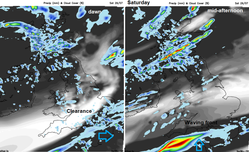
Saturday starts of blustery but the winds should ease for southern Britain by the afternoon with temperatures up to 23C for the SE and East Anglia. Further north it will feel cool in the breeze with further showers bustling in from the west. Northern Ireland and Scotland look prone with Co Down and eastern Scotland being most sheltered. Across much of England and Wales there should be a lot of fine and dry weather BUT we have this trailing front. Once it clears Kent early in the morning, it then lurks in the English Channel, probably bringing a grey, damp morning to the Channel Islands.
The forecast shows the frontal band waving back up into southern Britain during Saturday afternoon. Where it actually ripples over and how far north will have low confidence. So, it could be your weather app shows fine weather on Saturday, but the rain band nudges a bit further north and spoils your plans, or for your location there is a wet afternoon but in the end the band waves up further east, so misses you. Just keep in mind the overall picture for the forecast on Saturday over southern Britain. By the evening it does look like southern counties of England will be wet, Scotland still seeing lots of showers and in-between not bad with just the odd shower.
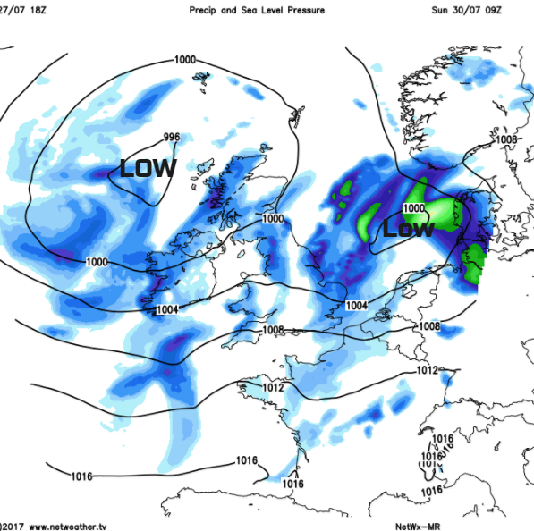
Overnight the southern rain will pivot over more of central/southern/eastern England, perhaps clipping Cardiff and SE Wales. That area of rain will clear from eastern England early on Sunday leaving brighter skies and warm sunshine. Yet again showers whirl in from the west as the blustery SW wind picks up for England and Wales
Next week
Easing off with the showers a bit in the NW and more fine, warm weather for SE UK. Monday and Tuesday look okay before another spell of wet and windy weather for midweek as another Atlantic low heads in for Wednesday.
It's not that sunny, should I put suncream on today? - UV radiation