


Cyclonic pattern set to dominate throughout the rest of July and into early August, potential longer term changes.
Issued at 1500BST on Thu 27th July based on Thu 27th July 00Z Model Runs
Key Points
Overview:
July is forecast to end with some particularly cyclonic conditions dominating the weather across many areas of the British Isles. While the month, as a whole, will likely lead to some distinctly varied regional weather conditions and averages, the overall pattern this month has been highly diverse and changeable. The broader synoptic pattern across the N Atlantic sees a strong trans-Atlantic jet stream, of which does seem to be a frequent occurrence of recent summers too. The development of a large and slow moving vortex, anchored to the NW of the UK, will maintain an unsettled pattern in the days ahead, while the jet stream will aid in frontal wave developments as well. The medium and longer term output remains firmly locked into a cyclonic regime, but with perhaps some tentative signs of an improvement beyond the opening week of August as the final summer, month arrives.
Synoptic Discussion:
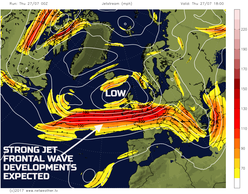
The 00Z models are all in excellent agreement for the main surface low pressure and upper vortex to be slow moving to the NW of the UK through the coming few days, while a particularly strong jet stream pattern dominates. It is this broader trend that will influence the weather not just in the short term, but also within the medium and longer term as well. The 00Z GFS is doing a good job of highlighting this pattern well.
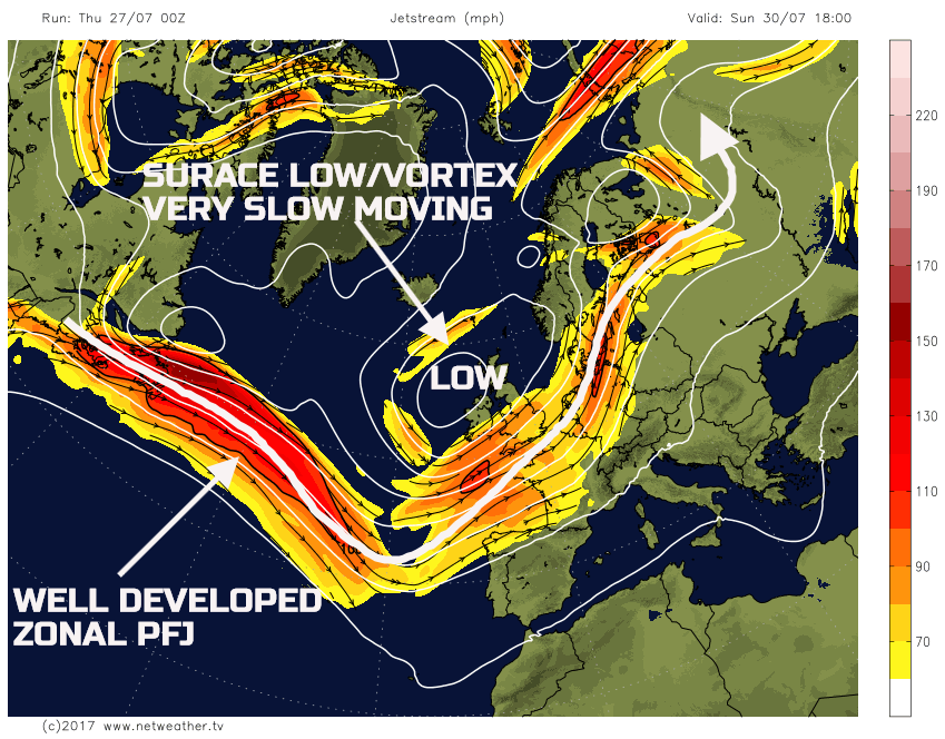
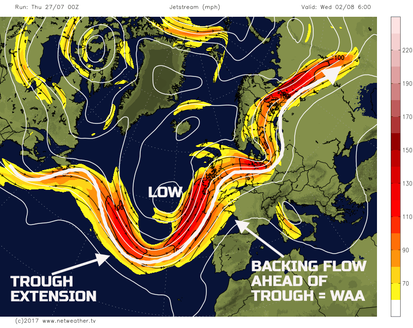
As we look further ahead through into the coming weekend and the final few days of July, the overall pattern across the N Atlantic remains very similar. The low-pressure to the NW of the UK is still in place, very slow moving indeed and this will continue to dominate the weather. The jet stream pattern across the N Atlantic remains particularly well organised and zonal for the time of year, of which will be reinforced, at times, by short-wave troughs moving through it. These short-wave troughs will bring about more short-term changes to the forecast but also lead to potential frontal wave development as well; one such feature is likely to bring some heavy rain to central and southern areas of England later on Saturday and through into Sunday.
This particular pattern is one that is extremely difficult to break down and shift. The vortex is, essentially, ‘locked in’ place across the British Isles and NW Europe, with the main PFJ running to the south of it, maintaining a consistent feed of cyclonic conditions across the UK. The weather over the weekend will be characterised by a convective regime, especially across the N and W of the UK, near to the vortex centre, while further S, those areas essentially situated beneath the PFJ will see potential frontal wave development. The GFS, ECMWF, GEM and UKMO model are all in good agreement regarding this synoptic pattern across the N Atlantic.
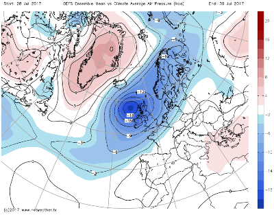
Covering the period between the 28th of July and the 30th of July, virtually the remainder of July, the MSLP anomalies are extreme across the British Isles in association with this synoptic pattern. While there are uncertainties over the mesoscale details, the model agreement, especially when the GEFS and EC EPS are analysed, means high confidence for a very cyclonic end to July and start of August. The 00Z GEFS on the 30th July highlights this particularly cyclonic pattern very well.
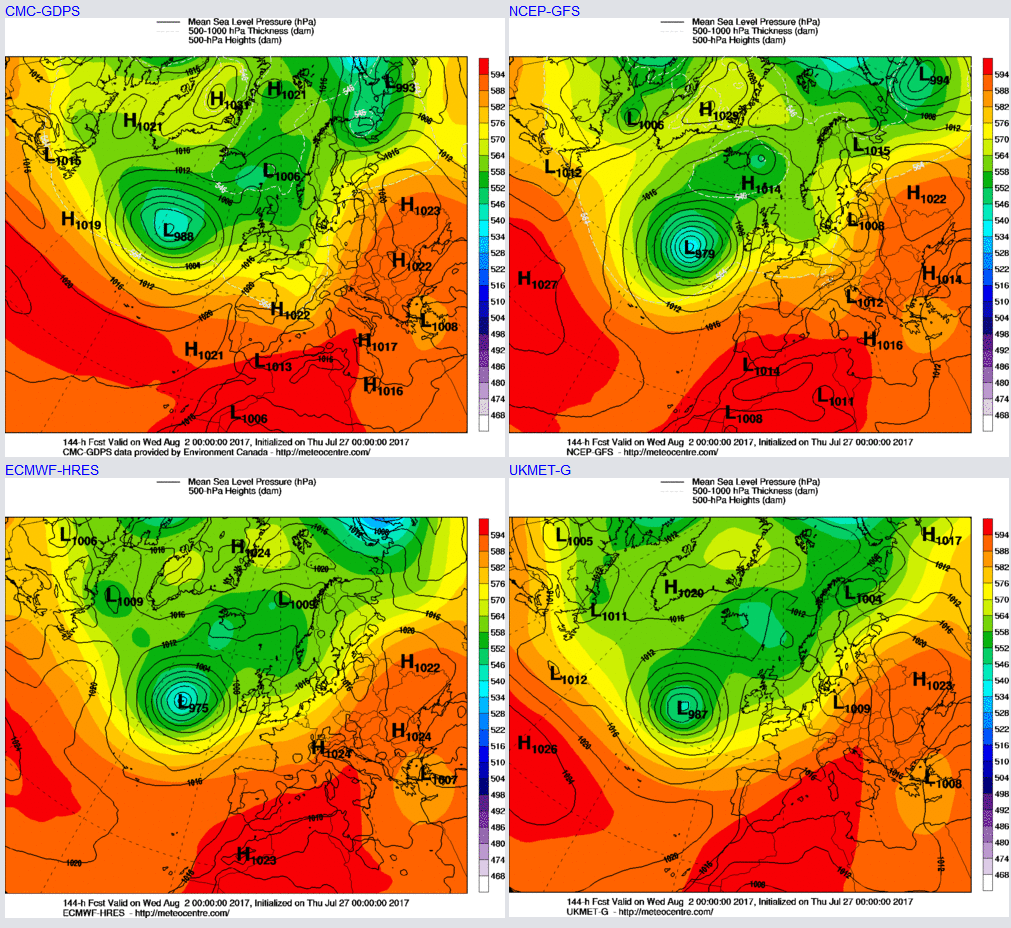
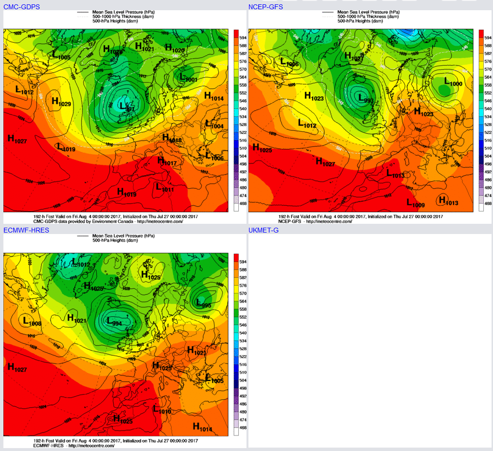
Looking further ahead into early August and it isn’t until next week that the unusually slow moving vortex will begin to show signs of weakening. However, at the same time, there is a reasonable model agreement between the UKMO, ECMWF, GEM and GFS for a developing low to move out of E Canada and then become a dominant feature within the N Atlantic. This feature may well then have some implications as we progress through the opening week of August, but the 00Z models highlight the expected position of this feature well by T+144hr (Wed 2nd Aug).
What this low-pressure may well do though is lead to trough-extension to the W and SW of the UK as we approach the middle of next week, so around the 2nd and 3rd of August. This extension to the SW of the UK may well lead to a backing of the flow and allow for warmer air to advect northwards into the UK off the near continent. This process has occurred a few times already this summer and is what has brought the ‘main’ spells of hot weather to the British Isles. The 00Z GFS highlights this potential development well, but there is support for this extension within the other models and ENS.
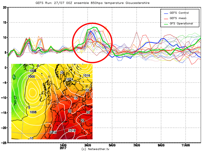
Exanimation of the GEFS 850mb temperatures highlights this potential increase in temperature through the middle of next week as the flow begins to back. However, despite this rise in 850mb temperatures the flow is still, overall, cyclonic so we may well be looking at a possible thundery period of weather towards the middle of next week. Depending on the finer details of the trough extension and how much WAA takes place, then a day or two of much warmer and more humid conditions may well arrive though, particularly so across England and Wales.
Longer Term (4th August Onwards):
As we look beyond this potential brief period of warmer weather into the middle of next week, the evolution is still cyclonic across the British Isles, which now takes us through towards the end of the opening week of August. The 00Z GFS, ECMWF and GEM GM’s, as an example, bring the main surface low pressure, and associated trough eastwards into the UK towards the end of next week, clearing away any WAA to the E of the UK.
It is likely, given latest model guidance and with some reasonable forecast model consistency as well that, overall, the opening week or so of August will remain predominantly unsettled now. Those hoping for a potential change in a month and a shift in the weather will likely be disappointed. While there could well be some transient warmth during the middle of next week, it is a cyclonic outlook. Inspection of the EC ENS Clusters between 192hr and 240hr all show a cyclonic pattern across the UK, essentially all 51 members indicating lower pressure being the dominant feature.
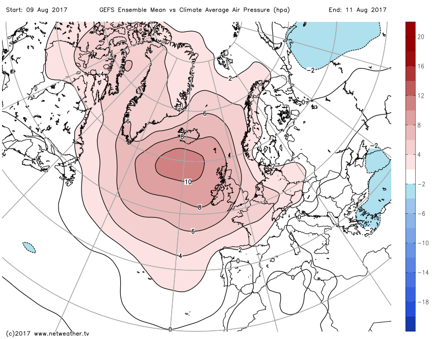
However, moving beyond this period and there are some tentative signs that the second week of August may well lead to change to more settled conditions. As the primary vortex and low pressure clear away, around the 5th or 6th of August, most likely to the E of the British Isles, it is at this point that a fundamental change in the synoptic pattern across the N Atlantic may well arise. The EC ENS along with the GEFS both indicate a potential shift towards a more anticyclonic pattern. The GEFS ENS Mean v Climate Average, regarding air pressure, highlights this well, with a particularly pronounced signal for higher than average pressure to the W or NW of the UK. While this pattern may well not be conducive to a heat wave or high temperatures, it would, at a minimum, lead a potential settled and more summery period of weather the further we progress into August.
It is, however, prudent to highlight that there have been some occasions so far this summer where high pressure has been a feature of longer range model output. However, when the time in question arrives, the high-pressure signal has never materialised, and this is most certainly the case for the latter half of July which, early in the month, did look as though it would be more anticyclonic than cyclonic. That will not be the case. So, a potential settled spell is forecast for the approach to mid-August at the moment, but with little confidence.


