Convective weather in the short term, ahead of a distinctly cyclonic and cool outlook.
Issued at 1500BST on Tue 18th July based on Tue 18th July 00Z Model Runs
Key Points
Discussion:
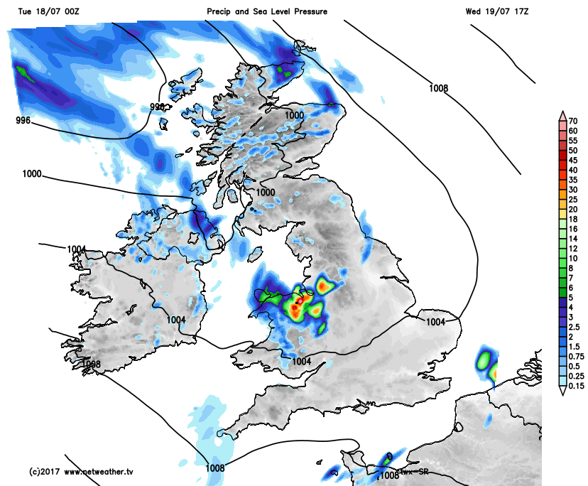
Wed 19th July: Overnight into Wednesday and the first region of convective activity is forecast to be moving northwards across parts of N England, N Ireland and S Scotland. This primarily driven by a northward region of vorticity and a +18C WBPT plume. At the moment, most of the convective activity within this area will not be rooted in the boundary layer but will be from the mid-levels, which will mean possible frequent lightning, but a lower risk of downpours.
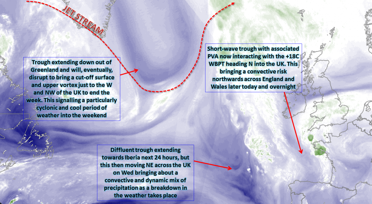
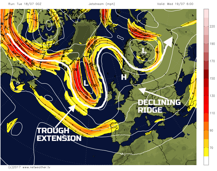
The whole pattern across the N Atlantic and the UK will be under-going complex changes into Wednesday. A trough extension down out of Greenland will become the primary feature of interest as disruption then takes place during the day. This process is then expected to lead to a surface and upper-level vortex that will dominate just to the W and NW of the UK through the day. A declining upper and surface ridge will also be in evidence to the E, this the remnants of the dry and settled weather earlier in the week.
The mesoscale details of the weather across the UK through the day will be particularly complex. The initial thundery weather will soon die away, once the forcing becomes displaced from the WBPT plume. However, it is the advancing and disrupting trough to the W and NW that will then combine with a hot and humid air mass over the UK to bring both a dynamic and convective precipitation risk. Most of the dynamic precipitation will be across Scotland and Ireland; some locally heavy rain is certainly possible here. However, across England and Wales, while there will be a lot of dry and sunny weather through the day, convective activity will develop. As the upper trough and associated vorticity arrive, this will combine with surface heating to bring about an unstable atmosphere. Some local-scale convergence zones will come in to play as well, but almost anywhere in England and Wales could see a thunderstorm on Wednesday afternoon. However, focus does seem to be across parts of Wales, the Midlands and N England, primarily due to some convergence influences here.
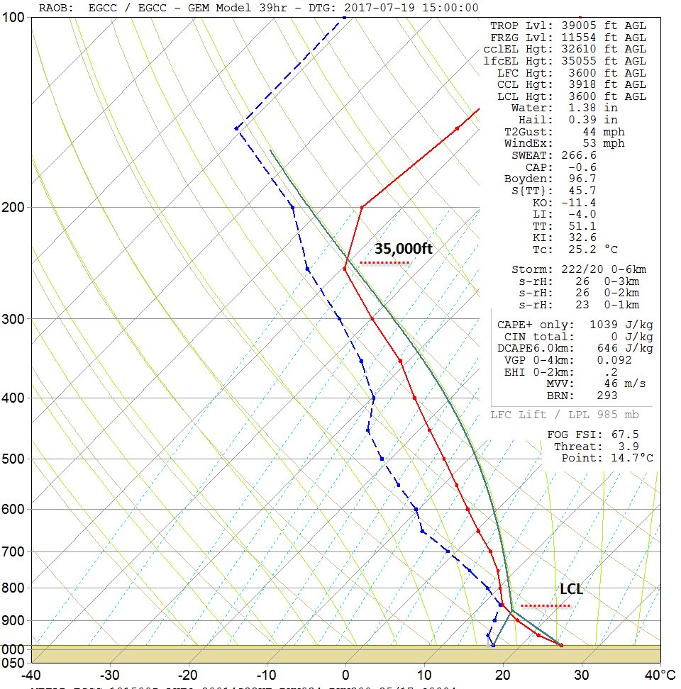
The forecast sounding for Manchester, through into Wednesday afternoon, highlights an entirely unstable atmosphere, of which is rooted within the boundary layer. Cloud tops to near 35,000ft are possible, and with some significant precipitable water totals too, perhaps 25mm to 30mm of more. As a result, torrential downpours, leading to flash flooding are possible, as is frequent lightning, relatively large hail and some strong wind gusts as well. As ever, these will be ‘hit and miss’, but where they do develop then severe weather is certainly possible.
There is some HRES model consensus regarding this development as well now, and our SR model highlights the areas at perhaps greatest risk through into Wednesday afternoon and evening.
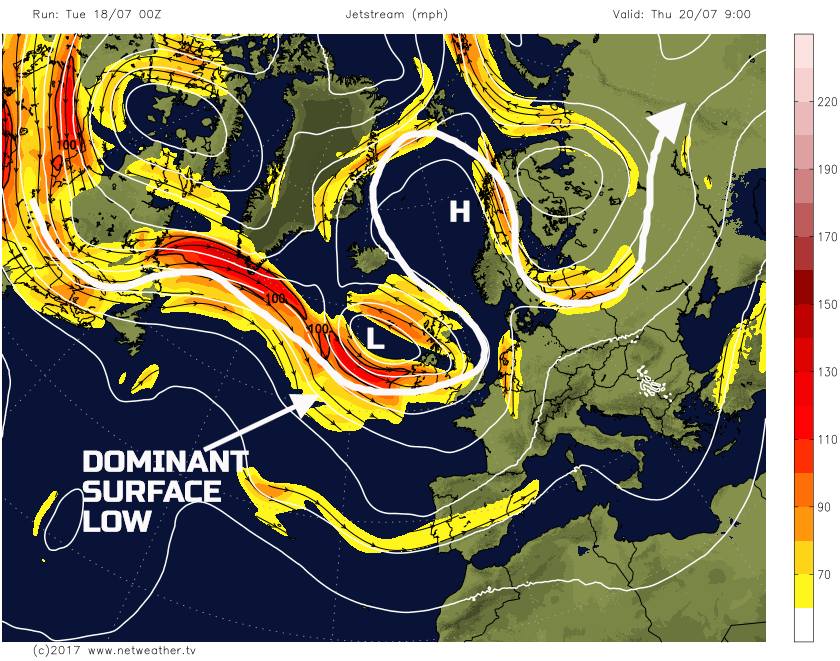
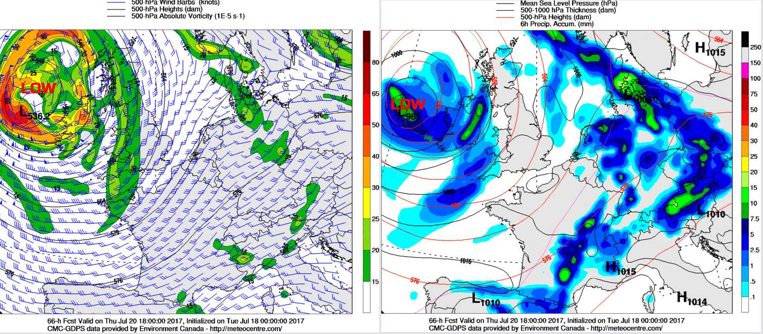
Thu 20th July: Into Thursday and the whole pattern across NW Europe will have changed. The marked WBPT plume will have cleared away to the E, and a significant drop in thicknesses will have arrived from the W. The disrupted trough, of which will have created a cut-off vortex will dominate the weather across the British Isles through the day.
Some overnight residual convective and dynamic precipitation may well still present across some eastern areas of England, perhaps across some northern and eastern areas of Scotland too. However, the thermal plume will quickly decline away to the E and, in its wake, will be a thermal trough. Showers or longer spells of rain are forecast to develop, from the W, through the day. While some drier and brighter intervals are still possible, quite widespread light or moderate, locally heavy showers will develop across Ireland initially and then spread eastwards into England, Wales and Scotland through the afternoon. Some local downpours are possible across more western areas of the UK beneath the thermal trough, where lapse rates will be particularly steep. The 00Z GEM model, along with the UKMO, ECMWF, and GFS is in good agreement regarding this development.
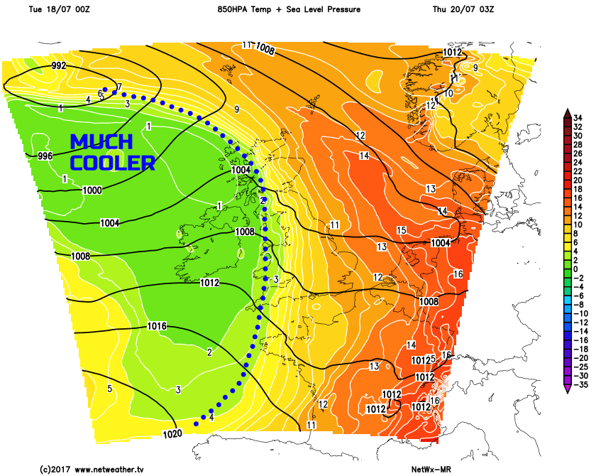
The drop in temperature on Thursday will be pronounced, this directly associated with an air mass which has its origins from across Greenland, but will have been modified by the N Atlantic. However, the drop in 850mb temperatures, for example, highlights this significant change in air mass across the UK compared with preceding days. 850mb temperatures, within the clearing thermal plume, are widely +12C to +15C, but following into the UK from the W, will be 850mb temperatures of no higher than +2C or +3C, an extreme thermal gradient across NW Europe through the day.
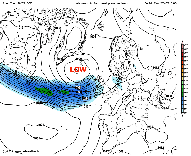
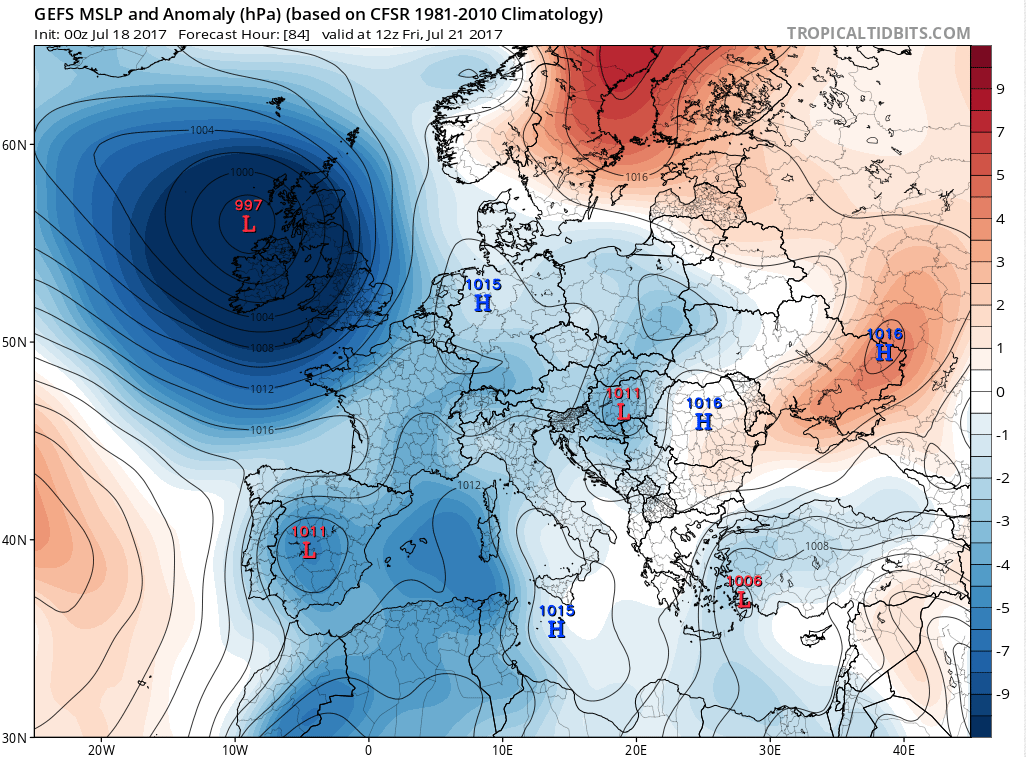
Fri 21st July: We end the working week in a very different manner from the way it started. The cut-off vortex will still be close by, if not drifting into the UK through the day. The 00Z GM’s are all in good agreement regarding this development and, as a result, the pattern across the UK will be particularly cyclonic for the time of year. This pattern is exampled very well by MSLP anomaly plots using the GEFS, for instance, with the –ve MSLP anomaly ‘off the scale’.
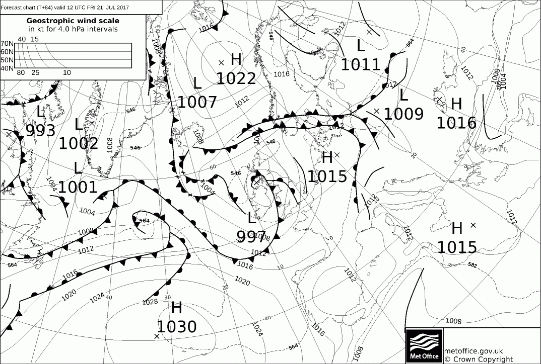
The 00Z UKMO FAX charts for 12Z Fri highlight a set of frontal zones that are forecast to move around the base of the main surface low pressure and develop as they move into the UK. The frontal zones will bring widespread moderate or heavy, dynamic frontal rain across many northern and western areas of the UK through the day, along with a moderate or fresh, perhaps strong S or SW’ly wind. The combination of the cooler air mass, the persistent frontal rain and the wind will make for a cool if not cold day across some areas of the British Isles. A complete contrast to the summer conditions earlier in the week.
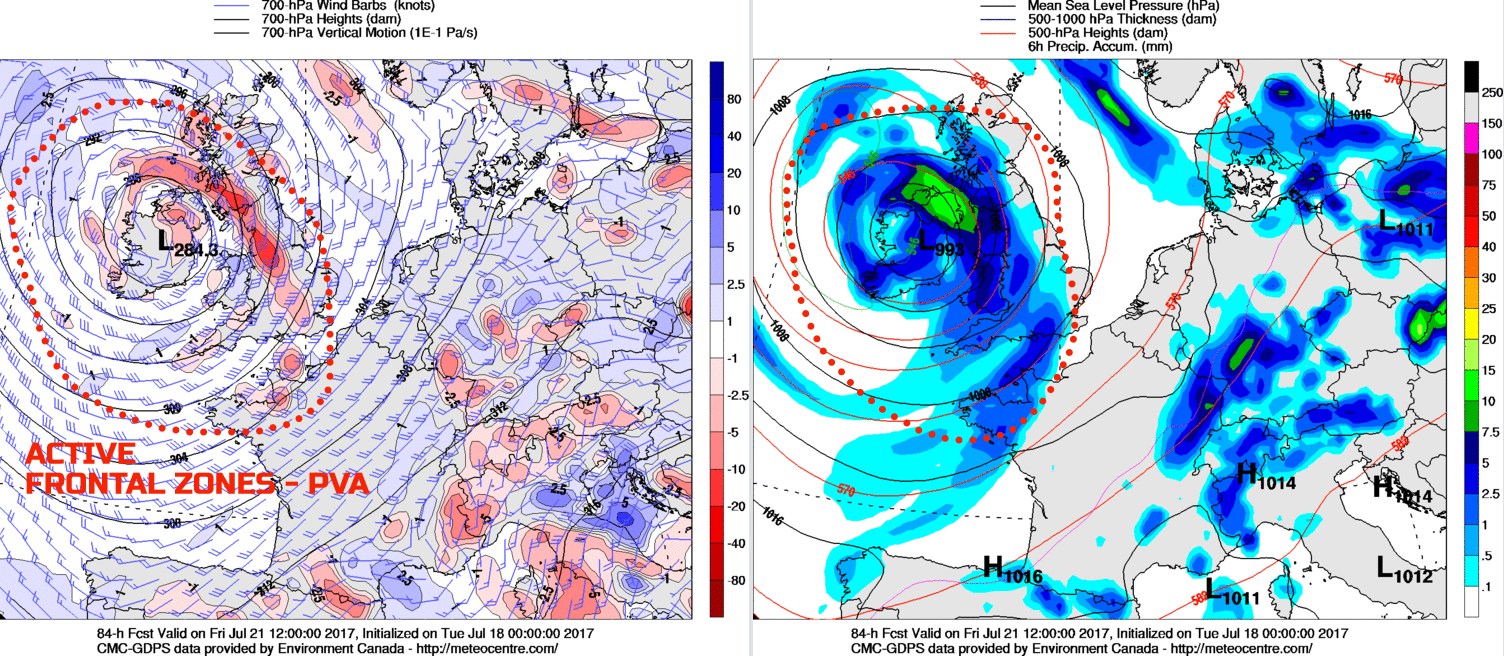
The 00Z GEM model highlights some of the details well. The upper vortex will be well placed directly over the UK and with the associated dynamic frontal precipitation in evidence across many N and W areas of the UK through the day, but this is spreading eastwards as the day progresses. The associated fronts do look to be well forced, as highlighted by the pronounced PVA at the 700mb level, so moderate or heavy rain is likely to be widespread.
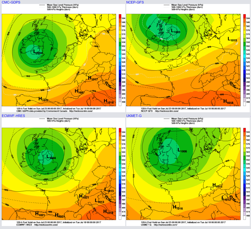
Sat 21st and Sun 22nd July: So, we move into the coming weekend, and it’s a cyclonic outlook for the time of year. The 00Z GFS, ECMWF, UKMO and GEM are all in good agreement for the main cut-off vortex and surface low pressure to drift eastwards across the UK over the weekend. While there are uncertainties over the mesoscale details, it does seem as though that showers or longer spells of rain will continue. Given the time of year, then any cloud breaks, allowing for solar input will lead to some significant convective activity given steep lapse rates. As a result, some torrential downpours are likely to be possible over the weekend, with scattered thunderstorms too. There may be some improvement into the far W of the British Isles later in the weekend, but overall emphasis is most certainly a very unsettled, cyclonic weekend with depressed temperatures, and with both dynamic and convective precipitation set to be widespread.
Medium and Longer Term 23rd July onwards:
Looking ahead towards the end of the month and there is likely to be further changeable and, at times, unsettled weather across much of the British Isles. There has been a reoccurring feature within the longer term now this summer, and that is with the likes of the GFS ENS, EC EPS and other guidance, signalling higher pressure to develop. However, when the longer term arrives this sign for a more anticyclonic environment across the UK fails to materialise and, overall, the weather is either unsettled or more changeable.
The weekend's low pressure may well clear away to the E to allow for at least a temporary build of pressure towards the middle of next week, perhaps an NE extension of the Azores high. However, the guidance continues to signal –ve MSLP anomalies to the W or NW of the UK towards the end of the month. As a result, this maintains a risk of further low-pressure systems running into the UK from the W and NW, along with a rather zonal jet stream pattern for the time of year.
As a result, the current thinking is the remainder of July will be unsettled, overall, but with transient spells of drier, warmer and sunnier weather across southern areas. We’ll be keeping a close eye on the longer term, so stay tuned for further updates in our extended Synoptic Guidance outlooks.